Headwaters to Hurricane Creek (3.8 miles)
Gauge Conditions
Runnable: 6.0 – 12.0 FT
Data from American Whitewater & USGS
Run Map
Run Time Estimate
Select put-in and take-out to estimate time.
Plan This Trip
See wind-adjusted speed maps, forecast planning, and detailed time estimates.
Sign in to generate an AI timing estimate for this run.
Whitewater timing varies with scouting, portages, and group pace. Use as a planning baseline.
Description
Note: The combination of Steep banks and lots of deadfalls tend to clog the creek with wood from time to time, so keep look out.
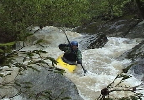
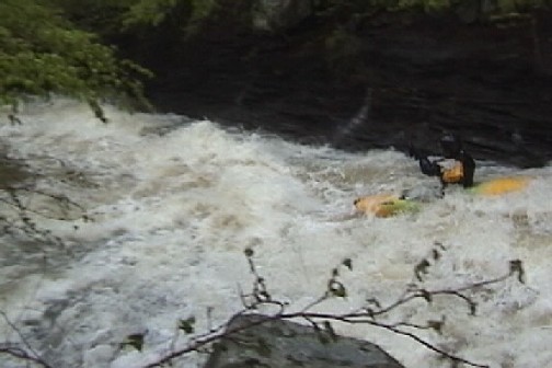
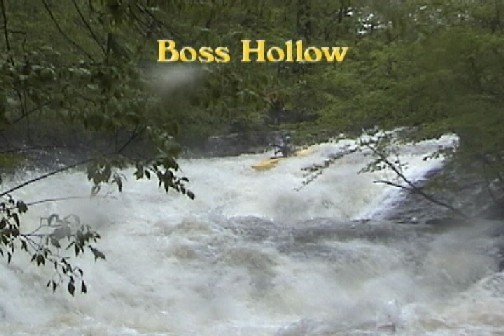
This is a very small creek. Tight slots, fast slides, waterfalls, undercuts. Highlight is "The Boss".
Gradient per mile: 190, 170, 90, 90 ft/mi. The Boss and steepest gradient is in first half of second mile.
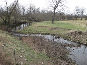
Put-in: Turn West from Hwy 7 at the "Who Would Have Thought It Gift Shop" North of Lurton. Take the left-hand fork (Newon County Road 7080) ~1.2 miles to the 6th 4WD road to the left. Park and carry or drive 0.75 mile (4WD only) to a cable/gate. An ATV trail leads downhill just before the gate. Drag downhill about 0.5 miles to put-in (elevation ~1560).
Take-out: Reach the take out by taking the right fork (Newon County Road 7050) at the gift shop down the hill to Hurricane Creek. At the bottom of the hill the road forks. The left fork (7050) fords a creek. If creek is high (which is needed for the Boss to be at a good level) park here and plan to carry boats out 0.5 mile after the run. Please park on the side of the road and not on any private property. If crossable, drive 0.5 mile to gate near remnents of a burned house. Turn right in front of gate and park near the creek. Alternate is for a long paddle on Hurricane Creek at big water to the Hwy 123 access on the Big Piney.
Description
The creek starts out fast and narrow dropping over several small slides and ledges. Approximately 0.25 miles there is a small ledge into a small pool. Now the tight and technical section starts. Lots of pin possibilities here. This is where the "Toilet Bowl" and "Baby Boss Slide" are encountered. These are followed shortly by "Face Slap Falls" and "Sycamore Slot".
After several more extended fast continuous rapids there is another small ledge into a small pool. The exit to the pool is usually cluttered/blocked with logs. Scout on the right bank. This is the entrance to "THE BOSS". This is the combination of the entrance slots "Performance Evaluation", the big slide "Broken Paddle" and the last ledge "Half a Paddle". Pick your way around the wood or carry. Run down the main channel to the left through a slot, over a ledge and down a narrow slide and hang a 90 degree right to the big slide. Make sure you slide down the right half of the slide to avoid the nasty vertical pin potential on the left side. The last ledge into a small pool can create a strong hydraulic. Drive left against the wall for the best escape from the hole.
Very shortly (100-150 yds) the creek takes a sharp turn to the left and funnels down a 3-4 ft. wide slot. This is "The Undercut!" A large house foundation sized slab rock at least 50% undercut. Run as far left as possible. (up on the wall is my preferred route) The next 0.3 miles to just above the confluence with Buck Branch is known as "Cheesegrater". A long continuous shoal with several surf holes. At low water it feels like a your sliding down a cheesegrater. (At least your boat will be lighter for the carry out!). Shortly below the end of the slide the creek narrows and funnels through a nasty strainer formed by the root wad of live tree, boof over or portage. The final 2 miles down Buck Branch have many class III drops and several play spots.
Beware in this section for downed trees and two notable undercuts. The first one is on far river right below a nice surf ledge/hole. The second is not far downstream and is nasty. This undercut is a huge flat rock facing upstream like an open mouth. The main current flows directly into and under the rock. Large eddies are above it on both sides and it is avoidable and noticeable, but it will gobble up wayward paddlers. (In April 2004 an offline paddler ran into and under this rock and disappeared in a creekboat. Luckily there weren't any snags and he flushed out the side a couple seconds later.)
Check out some video from this creek in the Ozark Update section of LVM issue #13.
More info and photos at:
Boss Hollow at Lance's Whitewater Page
Ozark Whitewater Page
Rapids in this Run (9)


Waterfalls (2)
Hazards & Portages (2)
Caution: The following locations may require scouting or portaging. Always check current conditions.
Difficulty
Class III-IV+
Length
3.8 mi
Gradient
140 ft/mi
max 210
Rapids
9
2 Hazards
Access Points
Shuttle Info
**Put-in:** Turn West from Hwy 7 at the "Who Would Have Thought It Gift Shop" North of Lurton. Take the left-hand fork ~1.2 miles to the 6th drive/road to the left. Park and carry or drive 0.75 mile (4WD only) to a cable/gate. An ATV trail leads downhill just before the gate. Drag downhill about 0.5 miles to put-in (elevation ~1560).
**Take-out:** Reach the take out by taking the right fork at the gift shop down the hill to Hurricane Creek. At the bottom of the hill the road forks. The left fork fords a creek. If creek is high (which is needed for the Boss to be at a good level) park here and plan to carry boats out 0.5 mile (flat). **Please park on the side of the road and not on any private property.** If crossable, drive 0.5 mile to gate near remnents of a burned house. Turn right in front of gate and follow to the creek. Alternate is for a long paddle on [Hurricane Creek](http://www.americanwhitewater.org/content/River_detail_id_3518_) at big water to the Hwy 123 access on the [Big Piney](http://www.americanwhitewater.org/content/River_detail_id_3921_).
Difficulty Classes
I Easy
II Novice
III Intermediate
IV Advanced
V Expert/Extreme
VI Unrunnable
Current Conditions
5-Day Forecast
Whitewater data from
American Whitewater
American Whitewater