Highway 42 to Buckhorn Dam Rd.
Gauge Conditions
Runnable: 100.0 – 3,000.0 CFS
Flow range for best boatability uncertain. Please help your fellow boaters with a comment or report.
Data from American Whitewater & USGS
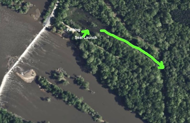
Run Map
Run Time Estimate
Select put-in and take-out to estimate time.
Plan This Trip
See wind-adjusted speed maps, forecast planning, and detailed time estimates.
Sign in to generate an AI timing estimate for this run.
Whitewater timing varies with scouting, portages, and group pace. Use as a planning baseline.
Description
Very short stream with surprising gradient for length. Takeout on dirt road that approaches Buckhorn Dam. Creek continues on into confluence with mainstem of Cape Fear River. Area is famous for deer and turkey hunting , sometimes during in and out of season, and also many horse lovers ride the many trails in this semi-remote area. Stream is subject to bank to bank strainers. Very, very underpaddled stretch of water to be so close to heart of Carolina Canoe Club domain.
Update on Running this for the rapids:
In terms of rapids in this stretch, there is a ripple right at Hwy 42, otherwise nothing before Buckhorn Road. You can park right by the creek on Buckhorn Rd and my recommendation is to park by the Buckhorn Dam at the Cape Fear River. The creek is class II, with II+ at higher water (250 CFS or higher). For the rapids, start anywhere near Buckhorn Dam; there is a trail that runs parallel to the river and creek. If water is very high, you can start at a pond right by the dam and paddle into the creek from there. About half a mile from the parking area several ledges drop about a foot each, some of which are fun easy surf holes. About 3/4 of a mile in, the creek curves to the right and there is a set of class II rapids with the biggest drops toward the end once you see an unexpected horizon line. For the most fun, hug river left catching two 2.5 ft drops with holes at the bottom. River right is a more gradual drop but the main flow will send you right into a rock that can flip you. This is followed by a small drop before flat water. The confluence is then about a tenth of a mile away. To make this run worthwhile, consider the more exciting rapids on the Cape Fear below Buckhorn Dam, which are most fun running either river right in the main channel or far right channel, working left and then ferry left of the island and far river left to get to Buckhorn Creek. You can then hike the trail to put in about a half mile. No matter how you run this, expect some significant hiking with your boat for less excitement than other runs in the area. If you want a quick taste of excitement, but don't feel like hiking too far, there is an old mill dam broken on the side at Cass Holt road before Harris lake. It's about 3.5 feet of a drop. Not anything else to offer here, but is a quick boof spot if you are in the area.
Rapids in this Run (1)
Difficulty
Class I-II
Length
3.8 mi
Rapids
1
Access Points
Difficulty Classes
I Easy
II Novice
III Intermediate
IV Advanced
V Expert/Extreme
VI Unrunnable
Current Conditions
5-Day Forecast
Whitewater data from
American Whitewater
American Whitewater