Indianford / Janesville Dams (PnP)
Gauge Conditions
Runnable: 2,400.0 – 5,600.0 CFS
Likely too low. (Likely no real whitewater play available.)
Data from American Whitewater & USGS
Run Map
Run Time Estimate
Select put-in and take-out to estimate time.
Plan This Trip
See wind-adjusted speed maps, forecast planning, and detailed time estimates.
Sign in to generate an AI timing estimate for this run.
Whitewater timing varies with scouting, portages, and group pace. Use as a planning baseline.
Description
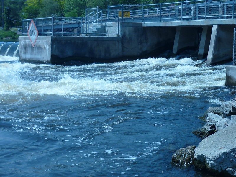
In general you don't want to mess with the main width of the dam at Indianford. Across that whole width, there is large rock rubble (in the landing zone and outflow) to reduce/eliminate hydraulic scouring (erosion) of the riverbed. The hydropower plant sits to river-right. On river-left, there are six releasable gates. Depending upon flow, and which gates on the dam are open, there _can_ be a sweet wave where the outflow from those gates hits the pool below.
Gauging can be a bit funky, since the nature of this wave will depend upon how many and how far the gates are opened (and possibly which specific gates in the event that they don't open all six equally), and also upon the river level downstream. Which is to say, a certain reported flow (or flow range) on the cited gauge, one time may be producing a wonderful fast playable wave, and at some other time (at the same gauge reading) may not produce anything remotely worthwhile!
If you are 'skunked' here, you are not far from the Yahara River and the Badfish River, either of which can offer a nice float trip with some (admittedly quite minor) rapids and play possibilities.
If neither of those interest you, you may wish to check out the dam at Rockton, IL.
Playspots (2)
Hazards & Portages (3)
Caution: The following locations may require scouting or portaging. Always check current conditions.
Difficulty
Class III
Length
0.1 mi
Rapids
0
3 Hazards
Access Points
Shuttle Info
Each location is a 'park-and-play', so you'll carry down to the river, and carry back to your car. The directions below will show how to get between these two dam sites.
You can use the text-entry box below to get drive time, distance, and directions to the Indianford dam.
Difficulty Classes
I Easy
II Novice
III Intermediate
IV Advanced
V Expert/Extreme
VI Unrunnable
Current Conditions
5-Day Forecast
Whitewater data from
American Whitewater
American Whitewater