Lake George to Lake Champlain
Gauge Conditions
Runnable: ? – ? CFS
Approximate reading: This gauge is 9.1 miles away on La Chute. Use as a general reference only.
Data from American Whitewater & USGS
Run Map
Run Time Estimate
Select put-in and take-out to estimate time.
Plan This Trip
See wind-adjusted speed maps, forecast planning, and detailed time estimates.
Sign in to generate an AI timing estimate for this run.
Whitewater timing varies with scouting, portages, and group pace. Use as a planning baseline.
Description
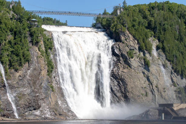
La Chute River (shown on some maps as "Ticonderoga Creek") drains the northern end of Lake George into Lake Champlain in the historic town of Ticonderoga. This is not a well-known stream, and it doesn't appear that paddlers run it with any regularity. Its character appears to be mostly quiet Class I or II, punctuated by a big drop: Carillon Falls, a 30-foot or bigger cascading waterfall which is the centerpiece of a park in the center of town, looks too bony to be runnable at normal water levels.
If anyone has personal experience running this crick, please post your beta here by clicking on the "Comments" tab and clicking on "Add a Comment" or email Matt Muir at matt at americanwhitewater dot org.
Note\* This is a highly visible drop. Best bet is to scout in plain clothes, put in at the bridge upstream and then take out at the park road near the pool. Be quick or you can plan on someone calling the fuzz.
Eastern Adirondacks Reaches
Ausable, E. Branch Ausable, W. Branch (1.) Ausable, W. Branch (2.) Balm of Gilead Brook
Boquet (2.) Boquet (3.) Boquet, N. BranchBoquet, S. Branch
Boreas (1.) Branch, The (Boquet trib.) Branch, The (Schroon trib.) Cedar (1.)
Cedar (2.) Cold Deer Creek (Hudson Trib.)Glen Creek
Hague Brook Hudson (0.) Hudson (1. Indian River to North River) Hudson (2. North River to Riparius)
Hudson (3. Riparius to the Glen) Indian (Hudson trib.) John's BrookLa Chute
MettaweeMill Creek (Essex County) Mill Creek (Hudson trib.) North Creek
Pike Brook PoultneyPutnam Creek Raquette (1.)
Rock River Schroon (North Hudson to Schroon Falls) Schroon (Starbuckville to Riverbank)Schroon (Warrensburg to Thurman Station)
Squaw Brook Styles Brook Thirteenth Brook Trout brook (Schroon trib)
West Mill Brook
Google Map of New York Whitewater
New York Whitewater Paddlers Facebook Group
Waterfalls (1)
Hazards & Portages (1)
Caution: The following locations may require scouting or portaging. Always check current conditions.
Difficulty
Class II-V+
Length
1.3 mi
Gradient
66 ft/mi
Rapids
0
1 Hazard
Access Points
Difficulty Classes
I Easy
II Novice
III Intermediate
IV Advanced
V Expert/Extreme
VI Unrunnable
Current Conditions
5-Day Forecast
Whitewater data from
American Whitewater
American Whitewater