Lake Horace to Everett Reservoir
Gauge Conditions
Runnable: 350.0 – 800.0 CFS
Data from American Whitewater & USGS
Run Map
Run Time Estimate
Select put-in and take-out to estimate time.
Plan This Trip
See wind-adjusted speed maps, forecast planning, and detailed time estimates.
Sign in to generate an AI timing estimate for this run.
Whitewater timing varies with scouting, portages, and group pace. Use as a planning baseline.
Description
Fall Drawdown Release
=====================
On a Saturday in mid-October, approximately 450 cubic feet per second (cfs) will be released into the North Branch of the Piscataquog River from the Horace Lake Dam in Weare.
This release starts at 8 AM and will be reduced to near normal levels by 4 PM that same day. The level may drop earlier if there is not enough water in the lake. DES reminds people that canoeing and kayaking have inherent risks, and paddling the state’s lakes and rivers is at the paddler’s own risk.
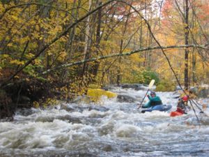
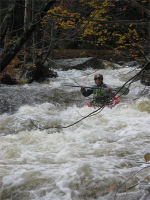
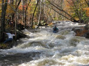
This is a 7+ mile, class III-III+ combination of technical drops, swiftly moving water and flat water through woods and scenic countryside. The river is narrow, less then 20' wide in many spots, providing a tight-but-passable run with many branches and blow downs that can protrude into the river. At times a paddler has to move carefully and occasionally pull off to scout or to portage an obstacle.
Here is a recent video of the entire run to Peaslee Rd.
https://youtu.be/NWc6OGufgqI?si=VgnhsFkV9FT0\\\_oab
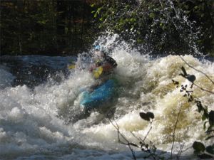
The river starts with a bang in swiftly moving water, channels through the trees, and few eddies. It quickly takes paddlers to the first class III drop, Slab City Ledge, and short-but-intense abrupt drop visible from the second bridge. Most paddlers opt to paddle center or far-left just kissing the wave-hole along the edge. The right side is full of rocks.
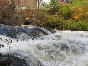
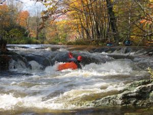
The next drop, Woodbury, offers a technical slide for the canoers and a creeky side run for the kayakers. It's followed by a number of smaller rapids.
About half-way down the river is the 'Big One', a big wide-open double-ledge slide-drop at the remains of an old mill. It starts with a slight drop over the remains of a dam, down the double-ledge slide, then a run-out through more rapids and holes. Most paddlers follow the curler down a rocky bouncy route and then through some holes at the bottom. The river is shallow here, expect plenty of bouncing and scraping off rocks and the river bed. Many open-boaters choose to walk the slide to avoid damage to boats as they bounce off the sharp rocks in the shallow water of the slide.
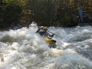
Buzzell’s is the most challenging rapid on the river; it's a medium length technical rapid. It requires that the paddler line up on staggered chutes that ultimately drop into a garden of large boulders, deep holes and a gnarly curler.
Many paddlers have trouble (and roll or swim) when they hit the big curler and get knocked over 3/4 of the way down. There is a good recovery pool.
After reaching the upper takeout, you'll enter a relaxing and one of the nicest parts of the river - a mixed flatwater/whitewater paddle through farmland, wooded areas and old homesteads. The river descends through eight more class II and III rapids to the middle and bottom takeouts. The most challenging rapids are the final two just above the bottom takeout.
It's about 1 mile from the upper takeout to the middle takeout. From there another two miles to the bottom takeout just above Everett Lake. Expect the paddle from the upper takeout to the middle to take about 15 minutes. From the middle to the lower is an additional 30 minutes.
For an excellent view of the biggest rapids look at this YouTube video.
This river is very narrow and tends to collect a lot of downfalls every year. Local groups of paddlers usually remove several of the trees every fall before the annual drawdown, but be aware new ones constantly appear. Be very cautious of blind drops. Also a note of caution there are the remains of dozens of old mill dams along this stretch. Some of these contain rebar.
Technical info
Drop per mile
Mile 1 .............54'
Mile 2 .............92'
Mile 3..............7'
Mile 4..............35'
Mile 5..............23'
Mile 6..............40'
Mile 7..............39'
Average 42' per mile
Max 92' per mile
Put in elevation 628'
Take our elevation 338'
Total drop 290'
The State of NH—Department of Environmental Services Dam Bureau, has a scheduled release for boaters the middle of October every year. The river additionally runs in the spring and after heavy rains.
Thanks to Andrew Fournier and Dan Corey for clearing this run for us in October 2019!
Historically, we should all thank Dave Amato for negotiating this and similar releases. A good turnout will show our support for recreational drawdown releases from the New Hampshire Department of Environmental Services and help to make this an annual event at a time when rivers are usually at their lowest levels.
Posted by Joe Fiala on the MVP message board.
The Upper P-Cat is at a good level and should stay fairly high through early spring. This one disappears quickly and doesn't come up very often through the year, if at all. This is a creek for newbies (but seasoned creekers will like it too). It is II-III, with a couple of easily portageable IV's. It runs close to several roads in Weare, so it is no problem to get to the road at almost any time--good for cold weather. It is a small creek, narrow and mostly quite shallow. Lots of slots. There are a number of 2 ft drops, some nice chutes. Everything is easliy scoutable, most of it from the road as well. It runs along Rt.77, Woodbury Rd., Reservoir Dr. (a short bit), and River Rd. The last section runs into old East Weare, which is the dirt road that bears left off of River Rd. , just east of Peaslee Hill Rd. You can follow the river (and scout) all along the 2 miles or so until you reach the lake. That is the takeout. It begins below Horace Lake and ends at Everett Lake, at the inlet on the opposite end of the dam. There is a fast, tight section over the last 2 miles that is easy to shuttle over and over. This is one of the coolest little rivers you'll ever run. If you don't believe me, ask Marc Aucoin.
Posted by Joe Fiala on March 6th, 2005.
Rapids in this Run (6)
Playspots (2)
Difficulty
Class II-III+(IV)
Length
6.9 mi
Gradient
42 ft/mi
max 92
Rapids
6
Access Points
Shuttle Info
The river is located in North Weare NH, gps coordinates N43.109328299, W-71.7737626726 The river is basically a class III with a couple tougher drops that can be carried.HoraceLake and Dam are fairly large and can supply water for most of the day.
Directions from Massachusetts / southern NH
Head north on US Route 93 to ConcordNH.
Take Interstate 89 toward Lebanon/Vermont travel 2.1 Miles,
Take exit 2 for Clinton St/RT-13 toward Concord
Turn left at Clinton St/RT-13 (signs for RT-13 S/Dunbarton) travel 4.0 miles
Continue on Concord Stage Rd/RT-77 travel 7.3 miles
Continue on Reservoir Dr travel .7 miles
Turn right to stay on Reservoir Dr travel .6 miles
Dam and put in on the left.
Google maps directions:
[http://tinyurl.com/2z2rt3](http://tinyurl.com/2z2rt3)
Difficulty Classes
I Easy
II Novice
III Intermediate
IV Advanced
V Expert/Extreme
VI Unrunnable
Current Conditions
5-Day Forecast
Whitewater data from
American Whitewater
American Whitewater