Lebanon (Route 727) to Clinch River
Gauge Conditions
Runnable: 1,400.0 – 6,000.0 CFS
Data from American Whitewater & USGS
Run Map
Run Time Estimate
Select put-in and take-out to estimate time.
Plan This Trip
See wind-adjusted speed maps, forecast planning, and detailed time estimates.
Sign in to generate an AI timing estimate for this run.
Whitewater timing varies with scouting, portages, and group pace. Use as a planning baseline.
Description
The put in is located on Rt. 721 and parking is on private property, so stop by the house located just above the creek and ask for permission to park. After this is taken care of, you can do a seal entry from the RR bank upstream of the bridge.
Once in the water you'll encounter some small rapids before coming to your first drop. The ledge is riverwide and drops about 4 vertical feet. Use caution when running this drop at high water, a VERY nasty hole develops here and will chew up boats and bodies and spit them out in little pieces. If the water is below 2500cfs, the ledge can be ran just about anywhere, the right center provides a nice boof at these levels. At higher flows, it is best ran on the river left side.
After this you should use some caution coming into the next bend due to a large amount of wood in the creek. A sneak is possible down the left side, however this could change with the next bit of high water. After the trees the creek continues at a mellow pace for about 2 miles through some really simple rapids.
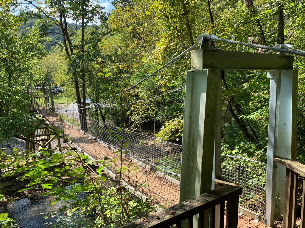
Once you start nearing the Pinnacle Natural Area the action starts picking up. You'll recognize the area by a swinging bridge crossing the creek. After this, you'll come across some nice playspots as well as a low water bridge. This can be run almost anywhere, the hole is rather friendly and you can even surf it. Use caution above 3000cfs, as the hole could get nasty.
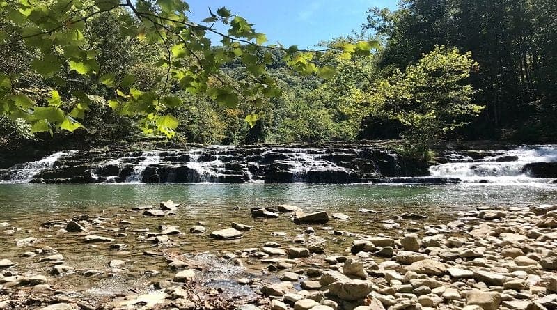
Once around the bend you'll notice the horizon lines that start appearing a short distance downstream. The first ledge is a quick S-turn on river right followed by a short pool that leads into the next ledge. This drop is about 6 vertical feet and is commonly run on the right of center following a small hump of water onto a tongue that takes you through the hole at the bottom. At high water you should approach this area slowly as the water picks up speed and takes you straight to the big falls in a matter of seconds.
After the second ledge, look for the horizon line indicating that you have reached Big Cedar Falls. This is the largest drop on the run, and the most fun. Take out on the left to scout. After scouting, the only decision to make is where to run the falls. Right of center or Left. The right of center line is very straightforward, line up with the tongue and ride it off the falls. This sets you up for a 16ft drop. The left side isn't that easy. It requires some precise boat control in very heavy water that is twisting and dropping out of sight. This is the harder of the two lines and probably the most exciting as well. Make a quick ferry to RL to avoid being carried downstream past the island. This provides a perfect opportunity to take a break and carry back up to make multiple runs of the falls. The carry isn't easy, but worth it. The last trip, a friend and myself carried back up and ran the falls five times and then carried back up to the parking area at the swinging bridge only to meet some friends coming down the creek and paddle back down with them.
From the falls the creek maintains a steady cl II-III pace with some really impressive scenery. One in particular is the 'Pinnacles,' a set of 500'+ cliffs along the creek. These cliffs have several different types of rock strata making for some really nice photos. A few years back I had the opportunity to participate in some high-angle rescue classes held on the cliffs and absolutely enjoyed every minute of it.
From here to the confluence with the Clinch river there isn't much to do except take in the scenery and occasional spotting of deer and beavers. Those beavers are some industrious little critters. Some actually float up beside you to see what this new 'critter' is floating in his 'house'. Really nice experience.
Once on the Clinch, you can experience some 'big' water that can be intimidating at high flows. There are a couple of ledge drops that one should keep an eye out for on the way. Nothing major and all have clean lines through.
Keep an eye out for several islands along the way and once they appear, start making your way to the RL side. The take out is located here near the little white church. Keep in mind that Big Cedar Creek from the area of the swinging bridge down to the Clinch River is located in a nature preserve operated by the Virginia Department of Conservation and Recreation (previously the Nature Conservancy). So be kind to your surroundings. They have really improved this area for use by hikers, fishermen, boaters and general picnics, if it weren't for the efforts of these folks we wouldn't have such a beautiful area to enjoy. If you make it down to Virginia's 'Outback' drop by and take in the beauty of nature here at Big Cedar Creek.
See Also:
_Virginia Whitewater_, Roger Corbett (2000 ed.), p. 387.
_Exploring Virginia's Waterways_, Ed Gertler (2022 ed.), p. 356.
Rapids in this Run (3)
Waterfalls (1)
Difficulty
Class I-III
Length
7.2 mi
Gradient
40 ft/mi
max 50
Rapids
3
Access Points
Difficulty Classes
I Easy
II Novice
III Intermediate
IV Advanced
V Expert/Extreme
VI Unrunnable
Current Conditions
5-Day Forecast
Whitewater data from
American Whitewater
American Whitewater