Let 'er Buck Trailhead Off-Trail Creek Access to Wooley Creek
Gauge Conditions
Runnable: ? – ? CFS
Approximate reading: This gauge is 9.1 miles away on Bridge Creek. Use as a general reference only.
Data from American Whitewater & USGS
Run Map
Description
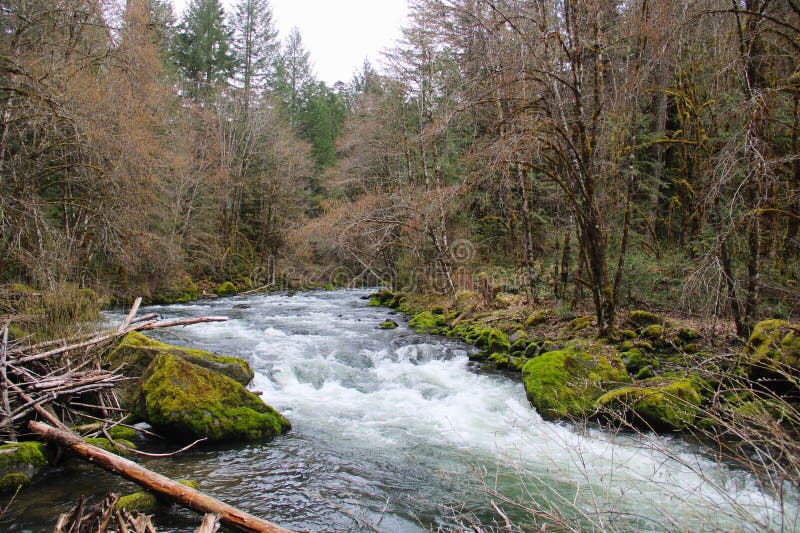
Everyone who has paddled Bridge Creek has a story.
Maybe they couldn’t find the trail to the creek (is there one?). Maybe they got poison oak everywhere—even in their mouths. Maybe they launched off clean waterfalls to glory, only to get beatered in the in-between mank (who hasn’t?). Or maybe, scarily, they fell into the rapid they were portaging or had four simultaneous swimmers in a group of six.
The first descent of this wickedly steep creek was done in an RPM. One boater hand-paddled most of Bridge and all of Wooley (bring a breakdown!). There’s even been a successful R-2 descent. One crew blazed through both Bridge and Wooley in just four hours—no overnighter for them.
But for many, an unintentional overnighter is part of the Bridge Creek experience. A growing number of boaters have found themselves out past dark with no camping gear (definitely not me). There have been some truly epic nights at the Fowler Cabin, the wilderness refuge for wayward kayakers. Once, an entire group of ten boofed the final waterfall in total darkness, each listening for the thud of the boater ahead before launching blindly into the starlit pool below—then crashing at the cabin (also not me). That oversized crew huddled around the fire eating SPAM and SpaghettiOs scavenged from rusted cans left by hunters long gone—a fate so grim that two paddlers stashed their boats and hiked out in the dark to avoid it.
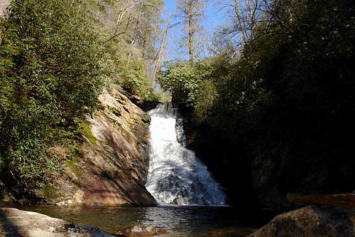
And if you ever find yourself at that last waterfall in the dark on your personal first descent, don’t let anyone tell you it’s a 10-foot autoboof. It’s not. It’s more than double that. You might want to throw in a boof stroke when it feels right. In the dark, the only thing auto is gravity—and yes, it still works just fine at night.
If you run Bridge Creek, you’ll have a story too. Please submit a trip report.
Much of the Bridge Creek watershed burned hot in the 2021 McCash Fire, and other sections have been hit by recent fires. This run will remain fire-affected for years. Bridge Creek has always had wood hazards; it just has more now. Some may question whether it’s still runnable: in May 2025, boaters reported 20 portages.
Just getting into Bridge Creek with a boat is an adventure. The journey starts at the Let’er Buck Trailhead. The access road is often snowed in late into spring, and downed trees are common—bring a saw. From the trailhead, hike the decommissioned road that drops down to the right. After about two miles, you’ll be high above Bridge Creek and ready to descend roughly 1,500 vertical feet. Look for a piece of old culvert pipe—your landmark for a faint path that dives steeply downhill. This isn’t the only possible route, but it’s the best. Some paddlers just pick a spot and go for it. However you get there, it’s steep. A rope or tether to guide your boat down is essential. The hike in is not the highlight.
The run itself alternates between clean rapids, waterfalls up to 25 feet, and chunky in-between sections that are less fun. The good outweighs the bad, and the setting is unbeatable: a spectacular wilderness canyon and one of the steepest runs in Northern California. Expect to portage wood and some drops, especially in the first mile—known as the “Mank Mile.” Do your research and know what you’re getting into: this is a full-on mission. The lower mile drops over 500 feet.
There’s no quick exit from Bridge Creek in the event you need to get out. However, the Bridge Creek Trail parallels the creek--though not closely--on river left until it intersects the Wooley Creek Trail. Be prepared to be fully self-sufficient and carry a Garmin inReach or similar satellite communicator. It’s your only way to call for help out here—and help won’t come fast.
Bridge Creek joins Wooley just after Fowler Falls and the footbridge over the creek. From there, you’ve got a glorious nine-mile run on Wooley Creek and a short half-mile paddle on the Salmon River to reach the Brannon Bar River Access take-out. Don’t forget to enjoy Wooley—though after Bridge, it may feel like a cool-down despite having some legitimate and difficult rapids; don't understimate Wooley.
If you need it, the Fowler Cabin is located just upstream of Bridge Creek and its footbridge along the Wooley Creek Trail. The unintentional overnight is common enough that it's worth planning this as an *intentional* overnight trip or at least being prepared with some extra layers and extra food, just in case.
Toz Soto, a Forks of Salmon local, discovered Bridge Creek’s boating potential while working on a summer fisheries crew surveying the creek. He returned the next spring with a couple of friends and his RPM to make the first descent—circa 1998.
Additional Info
Best guidebook: The New School Guide to Northern California Whitewater by Dan Menten, p. 95-97.
Dan Menten's Ode to Bridge Creek - great detail and photos from 13 runs down the creek
Darin McQuoid's Bridge Creek trip report
James Bagley's Bridge Creek trip report
Bridge Creek Raft Descent 2002 video
Rapids in this Run (2)
Waterfalls (1)
Difficulty
Class V
Length
3.1 mi
Gradient
440 ft/mi
max 500
Rapids
2
Access Points
Difficulty Classes
I Easy
II Novice
III Intermediate
IV Advanced
V Expert/Extreme
VI Unrunnable
Current Conditions
5-Day Forecast
Whitewater data from
American Whitewater
American Whitewater