Lower Chateugay Lake to Cooks Mill
Gauge Conditions
Runnable: 4.0 – 10.0 FT
Data from American Whitewater & USGS
Run Map
Interactive run map
Loads as you approach this section.
Run Time Estimate
Select put-in and take-out to estimate time.
Plan This Trip
See wind-adjusted speed maps, forecast planning, and detailed time estimates.
Sign in to generate an AI timing estimate for this run.
Whitewater timing varies with scouting, portages, and group pace. Use as a planning baseline.
Description
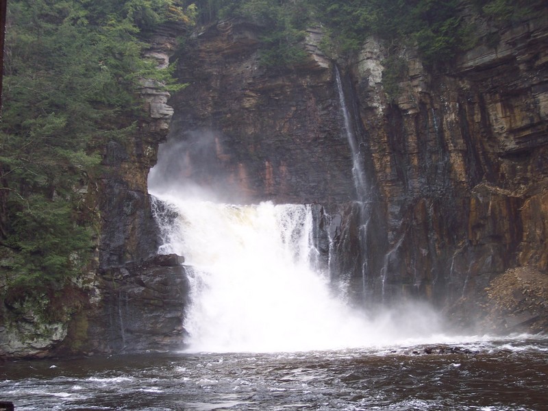
The Chateaugay is a very fun and scenic run in Northern NY, near the Canadian border. Much of the river is in a deep and committing gorge. There is a huge (100-ft) 2-stage waterfall on this run that looks pretty much unrunnable to me. There is also a large dam that is usually portaged. Because of the steep walls of the gorge, some of the rapids are difficult to scout and there are several places where it would be close to impossible to get off the river. The river also goes through a long tunnel. Make sure there is no wood in the tunnel before you run it. Overall, a great run.
Dennis Squires reccomends in his book to run laps on the top 2 miles taking out at High Falls for the best Class 4.
radpat shared:
"We ran this May 28 (2011) at 54m3/s (1900 cfs) on the gage in Huntingdon, Québec: See Hydro Quebec, click on Saint-Laurent sud-ouest, and then Huntingdon gage. (Lynx will open in a new window.) 54m3/s (1900 cfs) is very good and it's possible to stop and scout; 70m3/s (2470 cfs) is fast, with no scouting possible; 100m3/s (3530 cfs)...???
"The first 6 miles of rapids is class 2 nonstop, great for canoeing. Then the action starts one mile after you cross the big power line. We will try to put in there next time....looks like a half-mile walk to get to the road. The first rapids in the canyon can be run in the middle, then far left. Lots of small ledges and slides, one after another, in a 100ft tall canyon--no way to exit, with pocket-sized eddies, and no way to scout very much. No Scout Rapid is crazy, with a big rock in the middle at the end of the drop, with a monster hole and pinning risk. Run all the way right and then sprint left for the next drop to avoid a sticky hole. For the next drop, run staight in the middle or far right. Easy takeout before the (unrunnable) falls.
"Follow the road for an easy walk and trail on the left. After the falls, there's 1 mile of class 2 rapids before the tunnel. At the end of the tunnel is a 10-foot falls; jump out on the right. You should buschwhack the mountain to see if there is no tree in the falls. Next is 1 mile of small slides and play holes to the dam. Run straight in the middle of the dam and scream! A small rapid follows to recover in, if you're not dead. Next drop should be run on the far left. Then you will see a bridge and hit the last slide, a long, fast and furious slide rapid named Hey Diddle Diddle......straight in the middle......finish with one mile of class 2 rapids.
"Full facemask and elbow pads are recommended for this run."
_Thanks to radpat for this description! If you have more info on this or another run, please add a comment! Click on the Comments tab, scroll to the bottom, and click on Add a Comment._
Potsdam - Malone Area Reaches
Chateaugay Deer (Dickinson Center)
Deer (Dickinson Center to Lawrenceville) Grass (1. Lampsons Falls to Downerville)
Grass (Sec. 3) Grass (Sec. 4)
JordanLittle Trout
Marble Meacham Lake Outlet
Raquette Sec. 3) Hannawa FallsRaquette 2) Piercefield to Parmenter Site
Raquette Sec. 4) Stone Valley Salmon
Salmon (Chasm Falls) St. Regis
St. Regis, E. Branch St. Regis, Middle Branch (Sec. 1)
St. Regis, Middle Branch (Sec. 2) St. Regis, Middle Branch (Sec. 3)
St. Regis, Middle Branch (Sec. 4.) St. Regis, W. Branch (Sec. 1)
St. Regis, W. Branch (Sec. 2) St. Regis, W. Branch (Sec. 3)
Trout Brook
Plattsburgh Area Reaches
Ausable (Ausable Chasm) Ausable, E. Branch
Ausable, W. Branch (4. High Falls Gorge) Ausable, W. Branch (5. The Flume)
Ausable, W. Branch (Section 6) Black Brook
Boquet, S. BranchBoquet, N. Branch
Chateaugay Great Chazy (Chazy Lake to Miner Lake)
Great Chazy (Miner Lake to Mooers) Great Chazy, North Branch
Little Black Brook Little Trout
MarbleSalmon
Salmon (Lake Champlain) Saranac (Permanent Rapids)
Saranac (1. Union Falls to Silver Lake Road) Saranac (2. Silver Lake Road to Redford)
Saranac (3. High Falls Gorge) Saranac (Sec. 4)
Styles Brook
Google Map of New York Whitewater
New York Whitewater Paddlers Facebook Group
Waterfalls (1)
Hazards & Portages (2)
Caution: The following locations may require scouting or portaging. Always check current conditions.
Difficulty
Class II-V+
Length
12.4 mi
Rapids
0
2 Hazards
Access Points
Difficulty Classes
I Easy
II Novice
III Intermediate
IV Advanced
V Expert/Extreme
VI Unrunnable
Current Conditions
5-Day Forecast
Whitewater data from
American Whitewater
American Whitewater