McCloud Reservoir to Shasta Reservoir
Gauge Conditions
Runnable: ? – ? CFS
Approximate reading: This gauge is 4.1 miles away on McCloud. Use as a general reference only.
Data from American Whitewater & USGS
Run Map
Run Time Estimate
Select put-in and take-out to estimate time.
Plan This Trip
See wind-adjusted speed maps, forecast planning, and detailed time estimates.
Sign in to generate an AI timing estimate for this run.
Whitewater timing varies with scouting, portages, and group pace. Use as a planning baseline.
Description
The Lower McCloud is one of the best class IV overnight trips on the West Coast suitable for self-support kayaks and their inflatable brethren as well as small rafts. The river flows through the traditional homeland of the Winnemem Wintu people (the 'middle water people'), and they maintain an active presence on the river and are fighting for the restoration of its salmon runs that were blocked when Shasta Dam was constructed downstream in the 1940s.
Early in the 20th century, the river attracted wealthy San Fransisco families to waters that remain among the most exclusive fly fishing destinations in the West. Dean Witter, Ed Gillette, Levi Strauss, William Randolph Hearst, the Fisher Family, and Hills Family are among those who have been attracted to this river and its storied fishing waters. As a result, unlike nearly all other rivers in the region, the land along the lower McCloud is almost entirely privately owned.
The McCloud River’s spring-fed headwaters begin at Mt. Shasta in the Cascade Range. The river flows 59 miles through the Shasta-Trinity National Forest, although much of the shoreline is privately owned, until it joins with the Sacramento and Pit Rivers at Shasta Reservoir near Redding. Although upper portions of the river flow through the Cascade Range and its volcanic rocks, the Lower McCloud cuts through the easternmost portion of the Klamath Mountains on much smoother and harder metasedimentary rock that is more boat-friendly.
The Lower McCloud section begins at the base of McCloud Dam, constructed in 1960, where more than two-thirds of the river is diverted to the Pit River drainage as part of the McCloud-Pit Hydroelectric Project. While historic summer base flows on the Lower McCloud were 800 cfs, a flow that would have provided whitewater boating opportunities throughout the summer, today the river flows at 200 cfs except during spill events in spring or the during infrequent powerhouse or dam maintenance. While we won’t be able to restore summer boating opportunities, American Whitewater has successfully secured access to flow information, and we are working to secure modest improvements to instream flows in spring. We are advocating for a more natural ramp down of flows in the spring to avoid those situations where you have a trip planned and the flow suddenly drops out without warning as flows are abruptly cut from the dam.
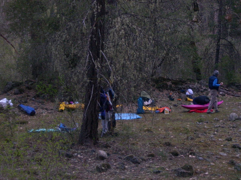
Paddlers with solid class IV skills can experience this special river that few have the opportunity to visit. While a long day trip is possible, an overnight trip on the McCloud is an experience to be remembered. This is a good self-support kayak trip but small catarafts or rafts (i.e., a ~12' boat) can be a fun way to enjoy the river. Some also enjoy this river as an inflatable kayak or packraft trip.
The furthest upstream put-in is at McCloud Dam and the river below here features one mile of class II/III whitewater before reaching Ash Camp. At Ash Camp, a standard put-in when flows are sufficient, the character changes and the next 2.5 miles down to Ah-Di-Na Campground features more challenging whitewater with half a dozen good rapids. The most challenging rapid is Amphitheater, rating IV+ or V-, and is a rock pile that is typically requires a portage at lower flows. The Pacific Crest Trail connects the Ah-Di-Nah access road to Ash Camp, making it possible to hike in with a packraft or other craft to start the run here. This is useful when access to the McCloud Dam is blocked by its owner, the Pacific Gas and Electric Company, as it is in 2023. The hike is fairly level and about three miles long.
Below Ah-Di-Na, a standard put-in at the lower range of flows, the river is mostly class II–III boulder gardens with long pools between the rapids until the character changes below Claiborne Creek. This section flows through The Nature Conservancy's Kerry Landreth Preserve, open to the public during daylight hours. It includes a three-mile section open to catch-and-release fishing for up to 10 individuals per day (permits administered by The Nature Conservancy). You will pass the caretaker’s cabin on river right and likely encounter a few fishermen along the 2.5-mile trail. A rope line strung high across the river marks the end of the fishing zone, but The Nature Conservancy property extends a bit farther downstream before you cross a short segment of public land and then enter the private lands of the McCloud River Club. You will know you are approaching when you see well-worn fishing trails along the banks and plaques identifying individual fishing holes (note the brass plaque marking Harvey Pool at the entrance to these exclusive waters). The main lodge is located on river left.
Shortly after you pass the lodge, you will paddle under the McCloud River Club Bridge. Immediately downstream of the bridge you will reach Claiborne Creek, a tributary that joins the McCloud on river left. The land on the downstream side of the confluence provides a good camping spot for those doing an overnight trip. Although it is close to the lodge, this area is on one of the few public parcels along the river under Forest Service management. If you spend the night here please be respectful and polite when the caretaker or guests of the lodge come by for a visit and manage your human waste properly. Check fire restrictions before your trip on the Shasta-Trinity National Forest alerts and notices web page (it is safe to assume fires are prohibited anytime between early June and late October, but they may be prohibited at other times too).
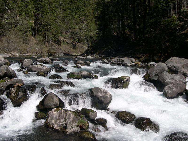
Just around the bend from Claiborne Creek the real fun begins with the McCloud Swim Club Rapid. This long class IV rapid has a few moves requiring you to stay on your game so as not become a member of the swim club. More fun read-and-run whitewater continues as you proceed downstream and you can expect a bump in flow as Yét Atwam Creek joins from river right. Werner's Profit is the double drop rapid just downstream of the Yét Atwam Creek confluence as the river bends around to the left. After passing under the suspension bridge, used by fishermen to cross the river, you know you will apporach Double Drop within the next mile. As the name implies, this rapid has a couple drops with hydraulics at the base of each one. Depending on flows and your skill, you can punch it down the middle or opt for the sneak to the left.
More fun read-and-run whitewater continues for the next three miles as you pass Pine Flat, and a private cabin on river right, then arrive at Tuna Creek Falls where Tuna Creek comes in on river right. This class IV+ or V- rapid is generally the most challenging drop on this lower section of the run. The rapid has a steep drop and hydraulic at the top, then a twisting channel that wraps around a house-sized boulder at the bottom that is undercut. The final move at the bottom end of the rapid to the right of the big boulder is not hard to make for those with solid skills, but the top hydraulic can set you off course. At lower flows, many boaters portage the top drop. Scout and portage on river right.
Just around the corner from Tuna Falls is the last big rapid, Valhalla (aka The Reagan Years). This Class IV+ rapid requires a diagonal move to avoid a big fan rock left of center. Have the photographer in the group run it first for a great shot looking back upstream as people come through this rapid.
The rapids ease below Valhalla to class II and III. One class III boulder garden has a nice looking center chute over about a four-foot drop; look out for the reversal at the base of this one that has caught some paddlers of guard who thought they were done with the big stuff. The scenery in this section is great as the river cuts some mini-gorges through slick limestone and the riparian corridor has many oak trees mixed with the firs and a few cedars. This whole section of the river would be inundated if Shasta Dam were raised, a proposal that would destroy Native American sacred sites, harm fish and wildlife, and provide few water supply benefits.
Soon after passing the Bolibokka Fishing Club on river right, originally founded in 1904, you will encounter the slackwater of Shasta Reservoir (full pool at 1067'; see current elevation). From there it is about a mile paddle down to McCloud Bridge take-out and a recreation site and campground on river left administered by Shasta-Trinity National Forest shortly after you pass the bridge.
Logistics:
This is a time-intensive shuttle so finding someone to run the shuttle is always a good option. Take a friend who wants to spend a day fishing at Ah-Di-Na campground who can then drive around to meet you at the take-out the next afternoon. Those groups running a traditional shuttle first drop a car off at the Shasta Reservoir McCloud Bridge Day Use area located high up on the McCloud arm of the reservoir where a bridge crosses the point where the river ends and the reservoir begins. Take exist 698 off I-5 and drive 17 miles on Gilman Road as it meanders along the McCloud arm (plan on a 40-minute drive).
To reach the put-in, head north on I-5 north of Dunsmuir but south of Mt. Shasta and take exit 736 on the Volcanic Legacy Scenic Byway (Highway 89) towards McCloud. In 15.6 miles from the interstate, turn south on Squaw Valley Road.
At this point you have three options for a put-in: the base of the McCloud Dam or Ash Camp, Ah-Di-Na Campground, or boat in on Squaw Creek.
Yét Atwam Creek: From McCloud, head 6 miles south on Squaw Valley Road and then turn onto the road leading to the Cabin Creek Trail. With this option you get 10 miles on Yét Atwam Creek (formerly Sq\*\*w Creek) and the last 10 miles on the McCloud which include some of the best whitewater. The option is only a possibility when flows are sufficient in Yét Atwam Creek, which can be estimated by subtracting the McCloud River inflow to Shasta Reservoir from the McCloud River at Ah-Di-Na.
Ah-Di-Nah Campground: Ah-Di-Nah Campground is a popular put-in for an overnight trip on the McCloud, bit it can also be done as a rather long day trip if you go quickly and without incident. If you set your shuttle the day before and camp at the campground (fee site), you will be well-positioned for an early morning start making a day trip achievable. From McCloud you will need to navigate Forest Service roads to get to this remote campground.
McCloud Dam: From McCloud, head 14 miles south to McCloud Reservoir. The river access road is on the far side of the dam and, as of fall 2022, is closed for reconstruction and PG&E is not allowing river access here.
Additional Information
California Creeks: McCloud River above Shasta reservoir < https://cacreeks.com/mccloud.htm >
A Wet State: McCloud (Ash Camp) < http://www.awetstate.com/McCloudA.html >
A Wet State: McCloud (Ah-di-na Camp to Shasta Reservoir) < http://www.awetstate.com/McCloudL.html >
Bollibokka Fly Fishing Club - The Fly Shop < https://www.bollibokka.net/ >
The Kerry Landreth Preserve, McCloud River < https://www.nature.org/en-us/get-involved/how-to-help/places-we-protect/mccloud-river-preserve/ >
Rapids in this Run (13)
Rapid
Ash Camp
Rapid
Ah-Di-Nah Campground
Rapid
McCloud River Club
 Rapid
Rapid
Claiborne Creek Campsite
Rapid
IV
McCloud Swim Club
Rapid
Yét Atwam Creek
Rapid
IV
Werner's Profit
Rapid
Suspension Bridge
Rapid
IV
Double Drop Falls
Rapid
Pine Flat
Rapid
IV+
Tuna Creek Falls
Rapid
IV
Valhalla Falls
Rapid
Bollibokka Fishing Club
Hazards & Portages (1)
Caution: The following locations may require scouting or portaging. Always check current conditions.
Difficulty
Class III-IV
Length
24.0 mi
Rapids
13
1 Portage
Access Points
Difficulty Classes
I Easy
II Novice
III Intermediate
IV Advanced
V Expert/Extreme
VI Unrunnable
Current Conditions
5-Day Forecast
Whitewater data from
American Whitewater
American Whitewater