Mono Hot Springs to Middle Fork, to Mammoth Pool
Linked via: Nhdplus gnis 95% confidence Synced 6mo ago
Gauge Conditions
Runnable: ? – ? CFS
Approximate reading: This gauge is 96.0 miles away on San Joaquin. Use as a general reference only.
Data from American Whitewater & USGS
Run Map
Run Time Estimate
Select put-in and take-out to estimate time.
Unlock Advanced Trip Planning
See wind-adjusted speed maps, forecast planning, and detailed time estimates.
Sign in to generate an AI timing estimate for this run.
Whitewater timing varies with scouting, portages, and group pace. Use as a planning baseline.
Description
This section was finally boated in late August of 2008, by Darin Mcquoid, Kevin Smith, Ben Stookesbury and Matt Thomas. They took 4 days to travel about 40 miles. They actually put in on Mono Creek below Mono diversion, because SCE was releasing 500 cfs from Edison reservoir down Mono Creek to the SF San Joaquin and then to Mammoth Pool. SCE had to transfer water for downstream farmers despite having several critical powerhouses down for maintanence.
Darin has a trip report with photos at JeffersonStateCreeking.
Ben has a trip report with video at: August 30th, 2008: South Fork San Joaquin
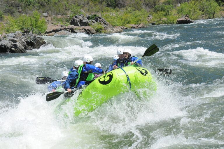
To our knowledge, up until 2008 there had been no descents of the SF San Joaquin past the Mt. Tom heliport and perhaps no descents since the early trips reported in Holbeck & Stanley. Lack of flow information and lack of dependable flows are big reasons for this. The scenery is fantastic and much of the boating is excellent. The boating that lies past Mt Tom to the middle fork confluence is steep and committing. Many difficult and challanging portages must also be overcome. 500 cfs is an optimum flow according to the first descent team.
After one reaches the Middle Fork confluence, additional issues arise as one must deal with the combination of flows and the remaining serious rapids and portages down to Mammoth Pool. During a spring or early summer run, flows in the middle fork will be high. Even side creeks in the SF will add more flow over the course of the run. The 2008 team reported that the 650 cfs flow (approximate) was an excellent level for the middle fork between the south fork confluence and Mammoth Pool.
There are a few situations in which boatable flows may be found in the SF San Joaquin.
Spring sills from Florence can provide moderate flows but usually provide flows that are high to much too high for boating. Even when moderate flows are released from Florence, the natural flows in the middle fork will be very high during any spring releases. These flows are good if boaters are willing to take out at Mt. Tom Heliport or at the Rattlesnake Crossing trail. Both options involve very long hikes.
Releases into Mono Creek from Edison reservoir sometimes occur in the summer. The timing and amount of these releases may provide the best potential for boating all the way down to the middle fork and on to Mammoth Pool.
Mono Hot Springs; 6560' elevation, topozone map, google map.
Middlie Fork confluence, 3700' elevation.
Mammoth Pool, is around 3400' elevation.
Average gradient from Mono Hot Springs to the middle fork is 136 feet per mile, but the first half is low gradient and the second half is high gradient. There are several sections of 300 + feet per mile.
Other information sources:
JeffersonStateCreeking 2008 trip report with photos
Rapids in this Run (3)
Difficulty
Class V+
Length
30.9 mi
Gradient
136 ft/mi
max 320
Rapids
3
Access Points
Shuttle Info
**Put in:**
From Fresno, take highway 168 to Huntington Lake,(1.5 - 2 hours), turn onto Kaiser Pass road to Mono Hot Springs, (40 minutes). Kaiser Pass road is narrow, windy and slow. Highway 168 is excellent and fast. At the junction of SR 168 and the Kaiser Pass Road is the Eastwood Ranger Station if you need info. Drive up the nice two-lane road for about 5 miles, and you'll come to the one-lane portion. Relax, it's only another 12 miles to Mono Hot Springs Resort. It is a rather narrow and winding, but paved road that takes approximately 40 minutes to drive. On the way, you'll pass the last Ranger outpost, the High Sierra station. A mile past that is the turnoff to Mono Hot Springs and Edison Lake. Just after crossing the bridge over the river, you will turn left into the Mono Hot Springs Resort. There are campgrounds along the river and dispersed camping near the trailhead for Doris Lake. Travel time from Fresno takes 2 to 3 hours.
**Take out:**
From the south take Highway 99 to Highway 41 north. In the foothills, turn right onto road 200 towards North Fork. Go through North Fork onto Minarets Road towards Mammoth Pool.
From the north, take highway 99 to Madera. Exit at the Millerton Lake - Yosemite turnoff. In Madera turn left onto W. Cleveland Ave, then turn left onto E. Yosemite Ave / highway 145. Follow highway 145 east to highway 41. Turn north and follow the same directions given above.
From Yosemite: Take highway 41 south to the Bass Lake road. Turn left to Bass Lake. Near Bass Lake bear left to the East side of the lake. Continue around the lake to North Fork, then turn left on Minarets Rd. Alternatively, if going directly to or from Mammoth Pool, it may be somewhat faster to take Beasore Rd, to Grizzly Rd, which ends at Minarets Rd about two miles from Mammoth Pool Road.
**Going between put in and take out:**
Go through Auberry and North Fork, and past Kerchoff reservoir.
Since this is expediton boating, you will probably just want to get a shuttle driver in Fresno or there abouts.
Difficulty Classes
I Easy
II Novice
III Intermediate
IV Advanced
V Expert/Extreme
VI Unrunnable
Current Conditions
5-Day Forecast
Whitewater data from
American Whitewater
American Whitewater