N2300 Rd to Vermilion River (0.5-1.5 miles)
Gauge Conditions
Runnable: 12.0 – 20.0 FT
Almost certainly too low. (Requires on-site confirmation.)
Data from American Whitewater & USGS
Run Map
Run Time Estimate
Select put-in and take-out to estimate time.
Plan This Trip
See wind-adjusted speed maps, forecast planning, and detailed time estimates.
Sign in to generate an AI timing estimate for this run.
Whitewater timing varies with scouting, portages, and group pace. Use as a planning baseline.
Description
Quick Facts:
Location: 2 miles SouthEast from Oglesby, or 5 miles SouthEast from LaSalle.
Shuttle Length: usually carry-up, 2/3 of a mile. (See details in description below.)
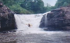
Character: A steep (not quite vertical) waterfall, and runout.
Put-in is approximately 539' elevation.
Take-out is approximately 469' elevation.
Thus total elevation change is approximately 70'.
Video: https://youtu.be/qiiFmeFWY5Y?feature=shared&t=169
General Overview
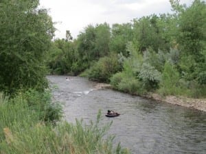
Bailey Creek is a tributary of the Vermilion. While it can be done on its own (using the put-in listed on this description name), the section above the falls is nothing but strainers with knee deep mud portages. Thus, Bailey is more often done as a side-trip while running the Vermilion.
Bailey Falls (in its present condition) is not a natural formation, but the result of quarrying. Click here to see a stereoscope image of Bailey Falls before it was quarried.
Bailey Creek is now part of the ILDNR properties, but has not yet been officially cleared for public access.
A third of a mile downstream of Wildcat Rapid, look for the mouth of Bailey Creek on river left. The hike up is about two-thirds of a mile on decent trail. From a gravel beach just past the mouth of the creek, go uphill about seventy-five feet to a dirt road. Turn right (away from the creek) and go another eighty feet to a small path ascending to the left. After 150 yards this path encounters a dirt road. Double back to the left on this, and hike a quarter-mile to a fork in the path. The left fork leads down to a large culvert in the river (referred to in the river description below). Bear right at this fork and continue another quarter-mile to the falls. (Partway along this stretch, a path/road heads off to your right and sharply uphill. You do not want to go that way.)
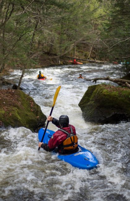
There is about a hundred yards of whitewater leading up to the falls. Unless the creek is quite high, I wouldn't bother with it -- it's just too scrapy.
Bailey Falls drops about twenty feet total, in a horse-shoe waterfall. It is not quite vertical, perhaps 70 degrees or so. Before running it, take a good look at the landing zone. It is inches deep at best. Running it means trusting a small roostertail to cushion your impact. DO NOT pencil-in on this one. A small, steep trail leads back to the top on river right for anyone wanting to carry up to run it again.
There is not any easy or convenient way (on river-left, where you'll be) to get to the base of the falls. There are sheer walls surrounding the 'pool'. So, if you have carried your boat up to here and decide not to run the falls, you have to decide if you are comfortable lowering or tossing your gear into the pool below and either attempting to climb down or jump in ('cannon-ball') after it. Otherwise, you will have to hike about 250 yards back downriver before the bluff diminishes enough that you can reach the river from river-left. Unfortunately, this gives you a very brief swift paddle before the serious hazard downstream at the culvert.
From the pool below the falls, there is a few hundred yards of ducking strainers and sweepers before the culvert. An ugly log jam completely blocks any reasonable possibility of running the culvert. No good eddy exists, so you must be very good and very careful to avoid the current pushing you hard and fast into the log jam. Generally this is portaged on river-right. Putting in below the culvert, at some flows there is a nice play hole in its outflow.
Downstream, several hundred yards of easy riffles lead to Pickup Rapid and the confluence with the Vermilion. There is a narrow channel between a river right rock and a rusted, jagged old vehicle laying in the creek bed. Stay as far right as possible, or portage this one, before continuing downstream on the Vermilion.
Rapids in this Run (1)
Waterfalls (1)
Hazards & Portages (2)
Caution: The following locations may require scouting or portaging. Always check current conditions.
Difficulty
Class I-II(IV)
Length
1.0 mi
Gradient
60 ft/mi
max 70
Rapids
1
2 Hazards
Access Points
Shuttle Info
This is virtually always done as a carry-up while running the Vermilion, therefore see details in the 'River Info' tab for the (carry-up) 'shuttle'.
Difficulty Classes
I Easy
II Novice
III Intermediate
IV Advanced
V Expert/Extreme
VI Unrunnable
Current Conditions
5-Day Forecast
Whitewater data from
American Whitewater
American Whitewater