near Webster City (0.3 mile)
Gauge Conditions
Data from American Whitewater & USGS
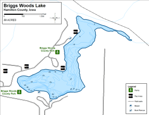
Run Map
Run Time Estimate
Select put-in and take-out to estimate time.
Plan This Trip
See wind-adjusted speed maps, forecast planning, and detailed time estimates.
Sign in to generate an AI timing estimate for this run.
Whitewater timing varies with scouting, portages, and group pace. Use as a planning baseline.
Description
Update 1/13/20
Briggs Woods is one of Iowa premier creek runs which only flows during heavy periods of rain. The creek is the outflow from Briggs Wood Lake and is great for running multiple laps. The USGS Iowa Mud Lake Drainage Ditch 71 is the best predictor if sufficient water is running with a minimum level of 83’ for good paddling:
https://waterdata.usgs.gov/ia/nwis/uv/?site\_no=05469860&PARAmeter\_cd=00065,00060
The Hamilton County Conservation Board has asked the paddling community to obtain a special access permit due to past problems in the location (the issues were not paddling related). The permit is good for a year and can be obtained by submitting the following form for approval from HCCB Executive director (hccblammers@wmtel.net).
!892138-1.jpg
\\*\\*\\*\*\*\*\*\*\*\*\*\*\*\*\*\*\*\*\*\*\*\*\*\*\*\*\*\*\*\*\*\*\*\*\*\*\*\*\*\*\*\*\*\*\*\*\*\*\*
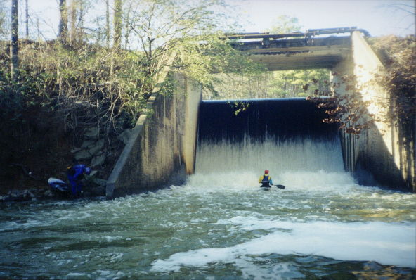
The run is an action-packed, fast ride which consists of five ledge drops. This ditch drops nearly 20 feet in 0.3 mile, for an 'effective gradient' of about 60 FPM.
The first 3 ledges are 3', 4' and 5' drops respectively. Punch them at the center for clean landings. A short section of flat water precedes ledges 4 and 5, which are closely spaced for a cumulative drop of 6+ ft (try to stay right of center at the very bottom to avoid a SHARP block that severely dents and gouges boats and flesh). Ledges 4 and 5 _can't_ be scouted from your boat. The best part is there's a trail that parallels the run allowing you to scout the section first, then bag multiple runs. Scouting is highly advised as there's a huge potential for strainers and beaver dams.
Two drainages feed this short stretch: one that feeds the lake/spillway which then merges with the other drainage (Ditch No.166) for the rest of the run to the Boone River.
Note: The cover photo above is the last ledge in Ditch No. 166 before joining the Boone River.
Flow: Check this site http://www.noaa.gov/ Type, "Webster City, Iowa" into the white box in the upper left. On the ensuing page look down the right side and click the "3 day history" link. Basically, from March to June, if there's been a consistent 0.05 to 0.1an inch of rain for the last 36 to 48 hours the ditch should be flowing.
Hazards:
Sharp rocks, narrow channel, micro-eddies, a fast ride. The spillway seldom has more than a trickle over it even when the ditch is flowing strong. If you do happen to find it cranking, scout it carefully and be warned that there are concrete 'current deflectors' about 12' from the spillway.
How to Get There:
Take Hwy 17 south from Webster City a couple miles until you see the signs for Briggs Woods County Park. Enter the park, go past the camp grounds & boat ramp and shelter 3 (north) to the end of the road. From there it's a short hike down to the spillway. Follow the outflow channel a little further to the ditch.
https://youtu.be/GPUhq-ncEUQ
Rapids in this Run (2)
Difficulty
Class II-III+
Length
0.3 mi
Gradient
20 ft/mi
Rapids
2
Access Points
Shuttle Info
Ignore the automatically created 'shuttle directions', since this is a short park-and-huck/park-and-play. Instead, use the text-entry box below to input your home (or other starting) address, to get drive time, distance, and directions to this location.
Difficulty Classes
I Easy
II Novice
III Intermediate
IV Advanced
V Expert/Extreme
VI Unrunnable
Permit Required
Permit is required with the Hamilton County Conservation.
Get Permit
Current Conditions
5-Day Forecast
Whitewater data from
American Whitewater
American Whitewater