New Oregon Rd. to East Church Rd.
Gauge Conditions
Runnable: 1,000.0 – 10,000.0 CFS
The min and max are a rough guess. (See the text for more gauge info.)
Data from American Whitewater & USGS
Run Map
Interactive run map
Loads as you approach this section.
Run Time Estimate
Select put-in and take-out to estimate time.
Plan This Trip
See wind-adjusted speed maps, forecast planning, and detailed time estimates.
Sign in to generate an AI timing estimate for this run.
Whitewater timing varies with scouting, portages, and group pace. Use as a planning baseline.
Description
South Branch Eighteenmile Creek, NY
12/16/02 Craig Mavis
The entire South Branch and Eighteenmile creek in itself can be run when snowmelt or heavy rains come up, but the best section and the most scenic for whitewater kayaking is a select portion of the South Branch as described below.
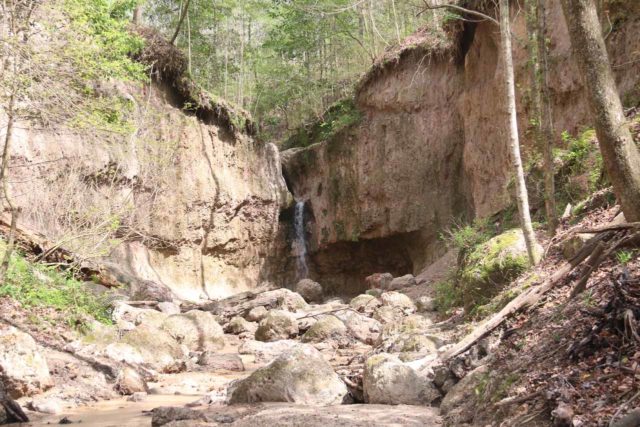
The Run \- After you put in on New Oregon Rd., you paddle a few oxbow bends and then go down a 12' slide type falls located on a 90-deg bend. You now enter the "Gorge Section" for some fun on twister-type waves. After another 1/2 mile, you encounter the remains of a concrete low-head dam next to a ranch house overlooking the creek. Look for strainers on this and run the chute that is most open. (Can be scouted on your shuttle from the road). Continuing along, you will encounter several 6-9' slides and a larger 25' slide prior to coming to "Clarksburg Falls." Scout Clarksburg Falls on your shuttle, as it is located at the intersection of Clarksburg Rd. and New Oregon. Clarksburg is about a 16' drop you run 5' off the left shore. Do not run river right! Watch for the Toilet Bowl on far river right after your landing.
Several more 5-7' drops (Dave's Hole) and slides are encountered prior to getting to the last big drop, Kromer's Falls. Kromer's can be scouted on the right bank by walking along the edge up to the brink. It should be run about 10' off the right bank under the grapevines. Kromer's consists of a 6' initial drop, followed by a long slide that tends to push you to the center and then a big 16-20' drop. Make sure to surf the bottom of the falls as this is the best surf wave on the river. Proceed another 300 yards and take out on river right at the bridge and hike up the right bank. The total time for the run is about 1 1/2 hours including shuttle unless you spend a lot of time scouting.
Levels are sometimes posted on www.zoarvalley.com.
Jaybird posted, on the FLOW Massage Board:
So after the monsoon on Sunday me and my buddy Max fired up 18 Mile Creek, which is about 30 minutes south of Buffalo. Not sure what to expect, we drove down a super steep hill into the bottom of the drainage and were happy to find an awesome 20' sliding falls. We put on about a mile upstream of the falls (known as Clarksburg Falls.) The run started with some class I-II boogie until the first horizon which was about a ten foot falls, runnable from any angle. Next up was an awesome 50-foot slide that you boofed onto and then out of over an eight-foot pourover. A bunch of boogie lead up to Clarksburg Falls, the highlight of the run. Like I said it was about 20 feet tall. The line was straight down the middle, over a roll in, onto a slate plate, and then off the last ledge--super fun. The creek now widened up and led over a 7-foot ledge that was pretty scrapy but boofable on the left as this level. A couple small slides, and the world's smallest surf wave and we got to the car, which some friendly locals had offered to shuttle for us. All in all, if the water in this 2.5-mile length of creek is very fun. The water held pretty well from the rain; the gauge correlation was 3,000 cfs on the Cazenovia creek site.
August creeking? Near Buffalo? You bet your boots!
Western New York Area Reaches
Beaver Meadow Creek Canadaway Creek (1.) Canadaway Creek (2.)
Canaseraga Creek Cattaraugus Creek Cattaraugus Creek, S. Branch
Cazenovia Creek, W. Branch (1.)Cazenovia Creek, W. Branch (2.) Chautauqua Creek
Clear Creek, N. Br. Conesus Creek Eighteenmile Creek
Eighteenmile Creek, S. Br. Ellicott Creek Genesee (Letchworth)
Honeoye Creek Keshequa Creek Little Chautauqua Creek
Murder Creek Niagara Oak Orchard Creek
Oatka Creek Rushford Lake Outlet Sugar Creek
Twentymile Creek
Google Map of New York Whitewater
New York Whitewater Paddlers Facebook Group
Waterfalls (2)
Difficulty
Class II-V
Length
3.5 mi
Gradient
50 ft/mi
Rapids
0
Access Points
Shuttle Info
The South Branch run follows New Oregon Road in the Towns of North Collins and Eden for most of its journey.
The put-in is 1.3 miles north on New Oregon Rd from the intersection of Langford Road (Rt 249) and New Oregon Rd. (Uncle Franks Bar on the corner of the intersection). 1.3 miles up is where the creek does a big Oxbow and comes close to the road.
To go to the takeout, proceed North on New Oregon Rd till it hits Sisson Highway (Rte. 75). Turn right on Sisson and go a mile or so and turn left on East Church Rd. Go over the bridge and park on the far side of the creek. The creek has been run further upstream in past years, however now there are a lot of strainers and large trees down to prevent this now.
Difficulty Classes
I Easy
II Novice
III Intermediate
IV Advanced
V Expert/Extreme
VI Unrunnable
Current Conditions
5-Day Forecast
Whitewater data from
American Whitewater
American Whitewater