Pocantico Lake to Sleepy Hollow cemetary
Gauge Conditions
Runnable: 700.0 – 2,000.0 CFS
Estimated. Please leave a comment if you have additional information.
Data from American Whitewater & USGS
Run Map
Run Time Estimate
Select put-in and take-out to estimate time.
Plan This Trip
See wind-adjusted speed maps, forecast planning, and detailed time estimates.
Sign in to generate an AI timing estimate for this run.
Whitewater timing varies with scouting, portages, and group pace. Use as a planning baseline.
Description
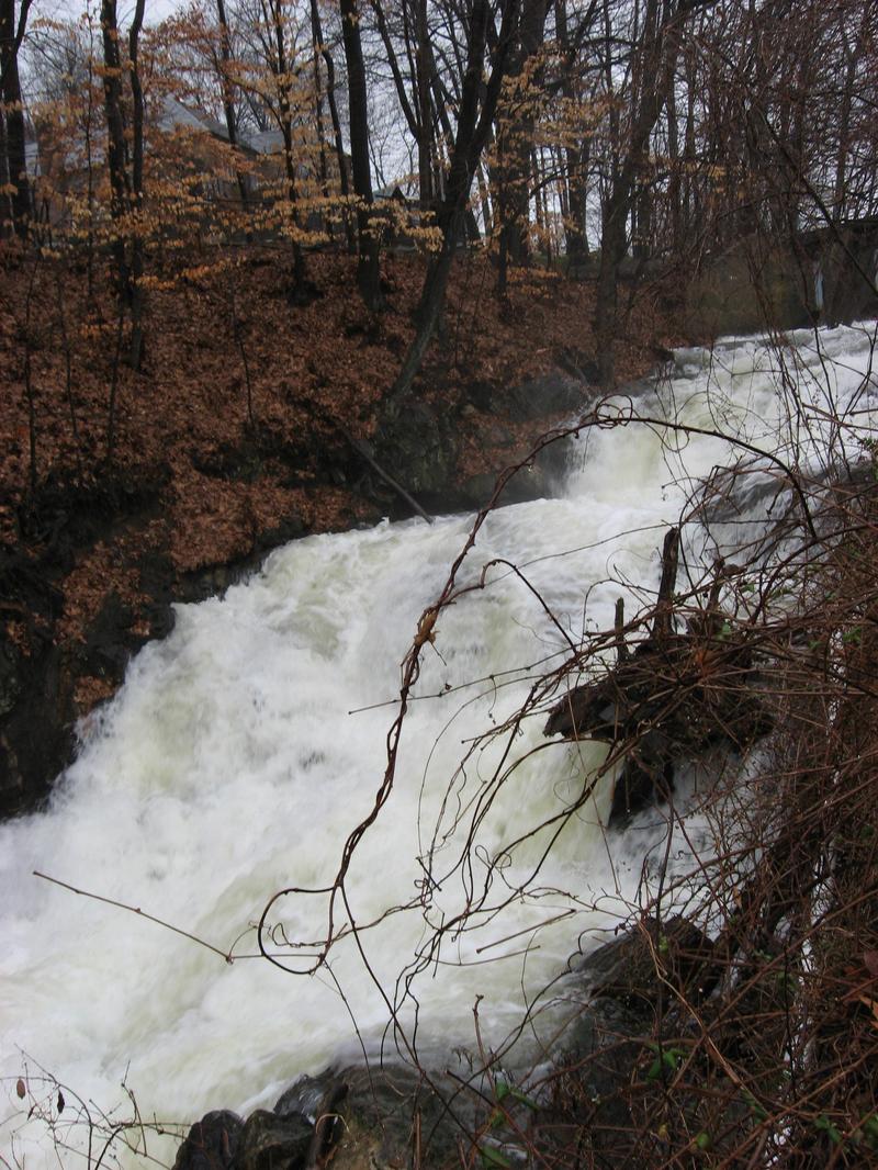
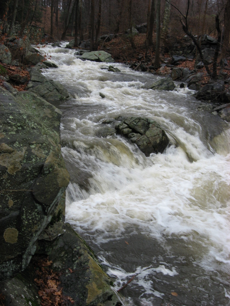
This is a small Catskillian stream which floats through Rockefeller State Park.
Paddle Head says that this is like a small Moshier, with 3-4 drops (Class IV) close together, but with room to recover. It's also a smaller stream, but with a sizable watershed and water dropping out of Pocantico Lake, it should retain its water pretty well.
'Jimmy' Dougherty and Tom McIntyre. wonder if maybe they snagged a First D on this one, on Dec. 1, 2006. Tom reports a cross stream pipe just before a dark tunnel that passes under the old aquaduct that carried water to NYC. Jimmy reported must-portage river-wide trees piled up in a large just downstream of the tunnel as you enter into the Sleepy Hollow Cemetary.
From an NPMB thread, begun 12/2/06:
Directions:
From Cold Spring: take 301 east to the Taconic south to the Sprain south. I'm 99 percent certain you can get on 117 and Bedford Rd west. Very shorty you'll bear left off of 117 onto Bedford Rd south? or west? to SleepyHollow Rd. At the intersection of Old Sleepy Hollow and Sleepy Hollow is a put-in option or walk upstream of the river or drive up a few yards (not a good place to park) and start at where the lake pours out. But scout this first drop--it's extreme and the hardest part of the river.
See also the Google Directions from White Plains.
Buck Webb offered alternative directions:
From the North: Taconic to Pleasantille Rd, Turn West (R), 1/4 mile to 9A south (Or just come down 9 to 9A).
Exit 9A at 117, go West (right). Left at first light (448). First right onto Old Sleepy Hollow Road. After about 1 mile you'll see the river on right, park at the intersection with Old Sleepy Hollow Road. (At this point the main road becomes Sleepy Hollow Road. You can continue straight to go along the river to the ledges You'll see a trail crossing and then, just after the ledges, the aqueduct pump house on left.) Bear Right off Sleepy Hollow Rd onto Webber then bear Right onto Bedford, then bang a Right onto N. Broadway (Rte. 9).
Go to the Citgo station, and turn right onto Dell St. for the south bank or Sleepy Hollow Ave (into the cemetary) for the north. This is a takeout.
This route avoids dribbling through Ossining town.
Downstate New York Area Reaches
Beer Kill Beer Kill, W. Branch
Callicoon Creek, E. Branch Callicoon Creek, N. Branch
Coxing Kill Croton
Delaware (1.) Delaware (2. Mongaup Wave)
Delaware (3.) Fishkill Creek
Mombaccus Creek Mongaup
Moodna Creek Neversink (1.)
Neversink (2.) Neversink, E. Branch
Peters Kill Pocantico
Popolopen Brook Ramapo
Rochester Creek Rondout Creek (1.)
Rondout Creek (2.) Rondout Creek (3.)
Sandburg Creek Stony Brook (1.)
Stony Brook (2.) Wallkill
Wappinger Creek
Google Map of New York Whitewater
New York Whitewater Paddlers Facebook Group
Waterfalls (2)
Difficulty
Class II-III+(IV)
Length
2.4 mi
Gradient
73 ft/mi
Rapids
0
Access Points
Shuttle Info
Basically, meetat Sleepy Hollow Rd and old Sleepy Hollow Rd ext. To get there, I get off the Taconic at 117, then I turn left onto Bedford Rd (117) and immediatly make a right onto Sleepy Hollow Rd (or is it Old Sleepy Hollow(?) it seems it's old sleep hollow and turns into sleepy hollow), take that until you see a bridge on your right (Old sleepy Hollow Rd Ext) Park there upstream of the bridge. There's sort of a trail that goes to the river. Then continue on Sleepy Hollow Rd Then you can either bear right onto a road (I forget the name) and take that to 9 or stay on Sleepy Hollow and make the next right onto Bedford Rd and make a right. When you get to rte 9, make a right (north) and very shortly you'll see the cemetary. Drive in and park where it looks good. Just get your car over as much as possible, there's no parking spots but it there are none in the cematary at all and there has not been a problem. Cemetary Closes at 4pm. If you think you might not make it back by 4pm, then park out side the cemetary. From the cemetary there's a road, Dell(?) that goes just opposite side of the river. There's many parking spots and there was/is an opening in the fence. The cemetary is on river right, this spot is on river left. You'll have big wooded beams that are like stairs up to the street. Also, be advised, when returning to the put-in, when you go up Bedford Rd, 448, Sleepy Hollw Rd will be on your left. The cross rd is funny, it's called Sleepy Hollow on your left (which is where you are going) but on your right it has a different name, although it's the same rd. This threw me off one day because I was looking to my right.
BTW if you are going back to the city and you took the Taconic to 117 to get here, be advised there is no Taconic south bond serv. I take the Saw Mill south and switch for the Sprain. This is better than going through Terry Town which moves along awfully slooooow. The roads are wierd around here.
Difficulty Classes
I Easy
II Novice
III Intermediate
IV Advanced
V Expert/Extreme
VI Unrunnable
Current Conditions
5-Day Forecast
Whitewater data from
American Whitewater
American Whitewater