Roswell (Vickery Creek)
Gauge Conditions
Runnable: 120.0 – 2,500.0 CFS
Data from American Whitewater & USGS
Run Map
Run Time Estimate
Select put-in and take-out to estimate time.
Plan This Trip
See wind-adjusted speed maps, forecast planning, and detailed time estimates.
Sign in to generate an AI timing estimate for this run.
Whitewater timing varies with scouting, portages, and group pace. Use as a planning baseline.
Description
This section is highlighted by the third of mile of Class 2 whitewater below dam and the gorge that the river cuts through on its final descent to the Chattahoochee River. In the not too distant past Big Creek received direct sewer overflow. The water quality has improved greatly, as can be quickly seen from the improved turbidity (down to 2-3 feet), the presence of insects, mollusks, and fish in the river. The creek is narrow above the dam, no more than 25-30 feet, and is subject to river wide strainers. Below the dam Big Creek widens to more than 50 feet.
For a map of this creek check out the National Park Service website
Vickery Creek
or the 2002 updated map.
### Grimes Bridge to the Dam: 1.6 miles
From Grimes Bridge Big Creek is impounded for nearly half a mile by a low-head dam that requires a mandatory portage. Just below the dam is the mouth of Hog Wallow Creek, entering from the right (mile 0.5). From here whitewater returns with a few Class 1-2 rapids. Soon the creek is crossed by an elevated sewer line that requires a portage. Just below the portage, on the right, is the western trailhead (mile 0.7) for the Oxbo TrailÂparalleling Big Creek from Hog Wallow Creek downstream. There is a parking area, which makes for an alternative put-in. From the parking area the creek stills as it bends to the left. In little more than a quarter mile from the Oxbo parking area the creek is crossed by another elevated sewer line (mile 1.2)Âalso requiring a portage. From here it is another quarter mile, as the creek bends to the right, to the still waters above the dam (mile 1.5)
Given the two impoundments and the necessity of making three portages, this section is better enjoyed on foot along the trails that parallel the Creek, either CNRA trail on river left from Grimes Bridge to Hog Hollow Creek, and below Hog Hollow on the Oxbo Trail.
### Dam to the Chattahoochee River (NPS Vickery Creek Unit): 1.0 mile
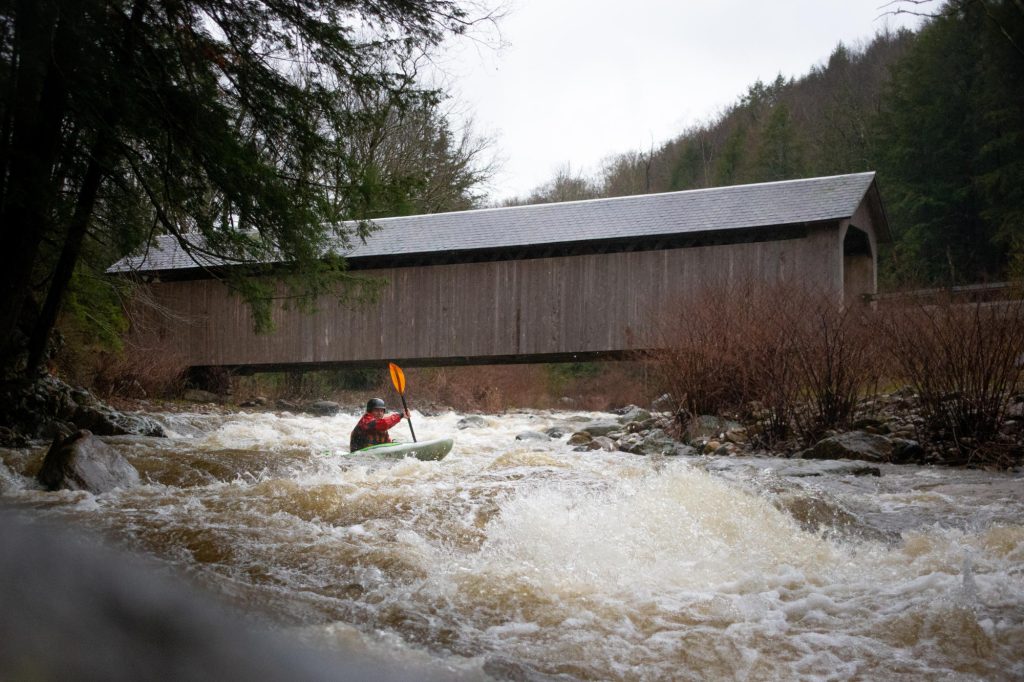
From the dam Big Creek enters the ÂVickery Creek Gorge with bluffs towering over the creek on both sides. To the right are the remains of the old Roswell Manufacturing Company, with the larger Roswell Mill (a textile warehouse further up the bluff). From the base of the dam the creek begins a quick descent, with a third of a mile of continuous Class 2 whitewater. Throughout this section are numerous eddies and surfing waves. Punctuating the ledges are three drops of note; the two highest are at the end of this sectionÂone below the newly constructed Covered Bridge and the third immediately below the last sewer line crossing. Here is one of the best surfing waves on the river just underneath the sewer pipe. The only hazard to note is in the pool just below the dam, the rocks on river left are undercut and the current is strong.
The river turns sharply to the left for its descent to the Chattahoochee. For little more than a third of a mile this section of Class 1-2 whitewater works through a gorge-like setting, with cliffs first on river right, just below the Allenbrook House and then with cliffs to on river left. Soon the descent ends and the river slows for another third of a mile. The recommended take-out is at the Vickery Creek Unit of the Chattahoochee National Recreation Area, on river right above passing underneath Riverside Drive (mile 2.6). If you decide to continue downstream to the Chattahoochee, there is another low sewer line that requires portage, just below the bridge.
Recommended put-in for this section: Vickery Creek Park (City of Roswell) off of Sloan Drive. From the small parking area near the cemetery, walk down the steps to the mill and then turn on the main trail, parallel to the river, to the left. There are two scrambles down to the pool below the dam.
Rapids in this Run (1)
Waterfalls (1)
Hazards & Portages (2)
Caution: The following locations may require scouting or portaging. Always check current conditions.
Difficulty
Class I-III(V+)
Length
2.5 mi
Rapids
1
2 Hazards
Access Points
Difficulty Classes
I Easy
II Novice
III Intermediate
IV Advanced
V Expert/Extreme
VI Unrunnable
Current Conditions
5-Day Forecast
Whitewater data from
American Whitewater
American Whitewater