Rugged Ridge Trail to Hyas Creek
Gauge Conditions
Runnable: 2,000.0 – 4,000.0 CFS
Data from American Whitewater & USGS
Run Map
Run Time Estimate
Select put-in and take-out to estimate time.
Plan This Trip
See wind-adjusted speed maps, forecast planning, and detailed time estimates.
Sign in to generate an AI timing estimate for this run.
Whitewater timing varies with scouting, portages, and group pace. Use as a planning baseline.
Description
This is a high-quality paddling run best enjoyed during the rainy season, but it requires effort to access. The approach involves a 2.8-mile hike along the Snider Jackson (also known as Rugged Ridge) Trail. Expect a mix of uphill and downhill sections as the trail crosses about six small tributary drainages. Be prepared for fallen trees on this lightly traveled path, which is mostly cut into a steep hillside and too narrow to drag a boat.
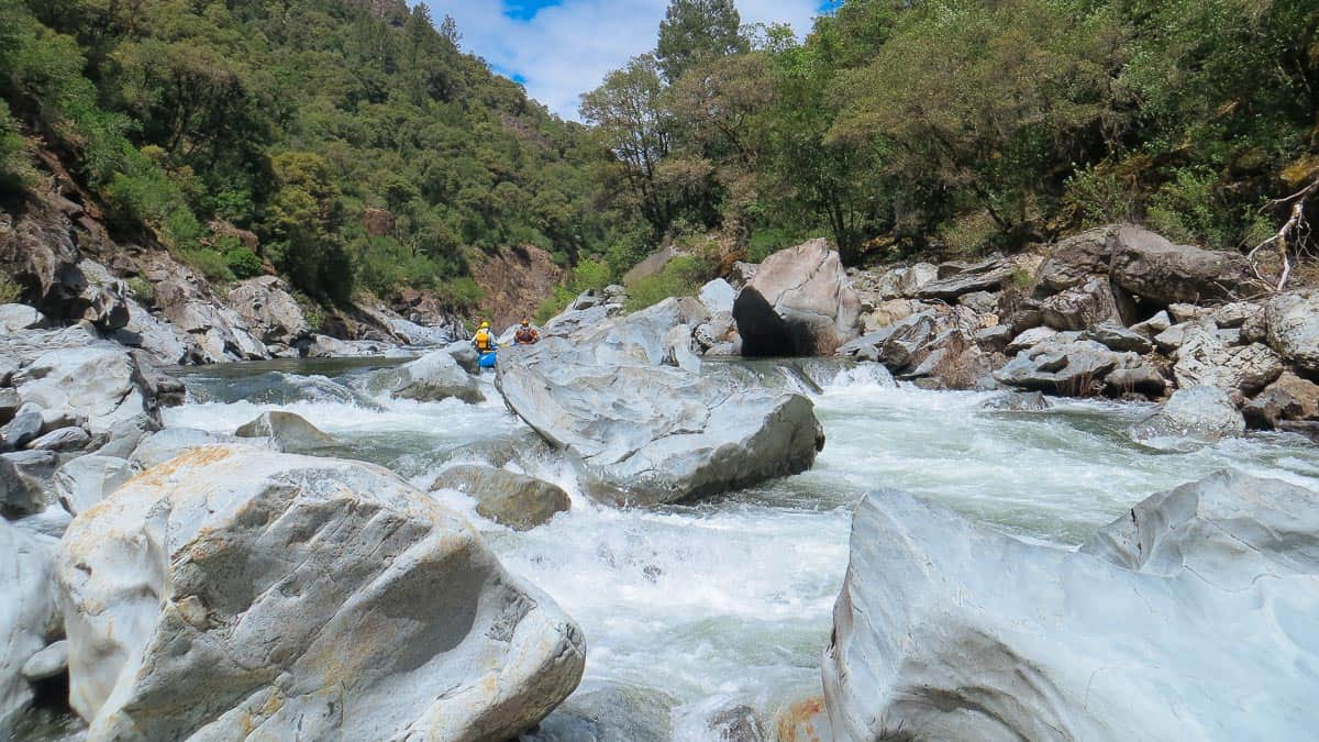
Once you reach the put-in, the action begins almost immediately. Around the first bend, the river enters a stunning bedrock gorge. The entrance rapid, known as \*West Virginia\*, offers multiple lines and rates as Class III/IV at intermediate flows. For the next quarter-mile, the river flows through the gorge with excellent Class III+ rapids before gradually mellowing. Towering Sitka spruce line the banks, and a series of boulder gardens keeps the run engaging with fun Class II/III rapids nearly all the way to the confluence with the Sitkum River. From there, it's just a few more minutes on the Sitkum before reaching Hyas Creek and the take-out.
At moderate flows, this run is suitable for strong intermediate paddlers, including pack rafters. Plan for 2–3 hours to hike in, depending on trail conditions and your fitness level while carrying a boat, followed by about 2 hours on the water if all goes smoothly. While the run itself is relatively short given the effort to access it, the true reward lies in the wilderness paddling experience. This is one of the best backcountry runs for intermediate boaters in Olympic National Park.
Access Logistics:
Take-Out:
About a mile north of Forks, Forest Road (FR) 29 branches off Highway 101 at mile marker 193.3 and heads east. Follow FR 29 for 8.0 miles to the Hyas Creek bridge. The take-out is at the Hyas Creek confluence with the South Fork Calawah River.
Put-In:
From the Hyas Creek bridge, continue 3.2 miles east on FR 29. Before reaching Rainbow Creek, turn right onto spur road 2900-070. After 0.2 miles, you’ll cross the Sitkum River over the Sitkum Gorge Bridge. Continue uphill for 2 miles to the Snider Jackson (Rugged Ridge) Trailhead. From there, it’s a 2.8-mile mostly downhill hike, with some uphill sections, to the put-in.
For current road conditions, contact the USFS/NPS Resource Information Center in Forks at 360-374-7566 or the USFS Ranger District office at 360-374-6522. For trail conditions, check the WTA Snider-Jackson Traverse trip reports.
For additional information see:
- Korb, G. 1997. A paddlers guide to the Olympic Peninsula. third edition.
- Olympic National Park website
- Pacific Ranger District, North - USFS Olympic National Forest website
Rapids in this Run (2)
Difficulty
Class III-IV
Length
7.5 mi
Gradient
53 ft/mi
Rapids
2
Access Points
Difficulty Classes
I Easy
II Novice
III Intermediate
IV Advanced
V Expert/Extreme
VI Unrunnable
Current Conditions
5-Day Forecast
Whitewater data from
American Whitewater
American Whitewater