Sevenmile Park: Trail 8 to US169 (2.4-5.3 miles)
Gauge Conditions
Runnable: ? – ? CFS
Approximate reading: This gauge is 8.7 miles away on Sevenmile Creek. Use as a general reference only.
Data from American Whitewater & USGS
Run Map
Run Time Estimate
Select put-in and take-out to estimate time.
Plan This Trip
See wind-adjusted speed maps, forecast planning, and detailed time estimates.
Sign in to generate an AI timing estimate for this run.
Whitewater timing varies with scouting, portages, and group pace. Use as a planning baseline.
Description
Quick Facts
Location: Midway between Mankato and St.Peter
Put-in: 44.28364 -94.07699
Take-out: 44.26226 -94.02905
Shuttle Length/DriveTIme: 5.2 miles/8 minutes.
Video Link: (Clickable Link >>>) _https://www.youtube.com/watch?v=13K0noqX7tI_
Put-in elevation is approximately 942
Take-out elevation is approximately 758
Total drop is approximately 184'
Gradient: Average: 37 FPM; Max Full Mile: 60 FPM
IMPORTANT NOTE: Gradient values should always be used for general comparative purposes only! Differences (even up to 15-20% and more) mean very little in the grand scheme of whitewater! Similarly, class/rating can mean relatively little. Far more important than either gradient or class/rating should be other less-quantifiable 'character factors' such as: (1) continuous versus pool/drop, (2) wide-channel with multiple routes versus narrow channel with essentially one route, (3) straight-shot routes versus complex technical maneuvering-required routes, (4) gradual river banks versus rocky shores or steep-walled gorges, et cetera. Never rely solely on class/rating to decide if you should run a river/rapids!
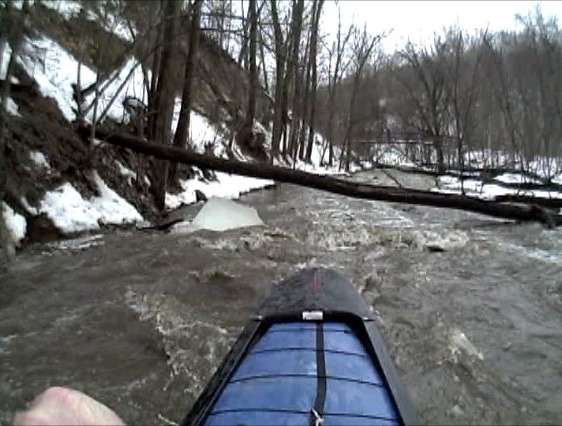
Character: Fairly continuous current and low-grade rapids; technical maneuvering skills mandatory due to everpresent deadfall and logjams.
River banks: Heavily wooded
Typical width: 15-30 ft. (any decent-sized branch/stick caught on a rock in the flow can block a substantial width of the creek)
Drainage area at put-in: 14.3 square miles
Drainage area at take-out: 36.3 square miles
Drainage increase: 154%
General Description
Midway between St. Peter & Mankato, Sevenmile Creek runs through Sevenmile Park. Depending on flow (and boater's inclination) this can either be done as a carry-up from within the park, or as a longer run with vehicle shuttle.
'MnktoDave' opines it's ' _a fast & narrow, tight & twisty creek with class 1-2 rapids, & class 2-3 trees, depending on the level. A really fun run....when it's running.'_
Rapids in this Run (7)
Hazards & Portages (1)
Caution: The following locations may require scouting or portaging. Always check current conditions.
Difficulty
Class I-II
Length
5.3 mi
Gradient
45 ft/mi
Rapids
7
1 Hazard
Access Points
Shuttle Info
We have very little info on this run. This may be a carry-up/paddle-down (park and play) run. If so, shuttle directions are meaningless. However, use the text entry box to input your home or other starting address to get drive time, distance, and directions to this stream.
Difficulty Classes
I Easy
II Novice
III Intermediate
IV Advanced
V Expert/Extreme
VI Unrunnable
Current Conditions
5-Day Forecast
Whitewater data from
American Whitewater
American Whitewater