South Street to Indian Hollow Rd. Chesterfield
Gauge Conditions
Runnable: 350.0 – 2,000.0 CFS
Gauge is on a nearby river, and range estimates are VERY UNEDUCATED GUESSES. Please report your runs or email me if you have better beta! The Mill River has
Data from American Whitewater & USGS
Run Map
Run Time Estimate
Select put-in and take-out to estimate time.
Plan This Trip
See wind-adjusted speed maps, forecast planning, and detailed time estimates.
Sign in to generate an AI timing estimate for this run.
Whitewater timing varies with scouting, portages, and group pace. Use as a planning baseline.
Description
The Dead Branch is a continuous Class IV boulder garden with one class V rapid towards the bottom. It is swamp fed and can be run rather low the day after a good rain, or it can be run the day of the rain at higher flows for more of a class V feeling.
There is a rapid under the bridge at put-in. This rapid is easier than the meatier rapids in the heart of the Dead Branch. If it does not look like fun, drive over and run one of the sections of the Westfield proper. If there are eddies in this rapid, you should have eddies below. If it is a big, continuous rapid, expect the same (but bigger and longer) for your run. Below the warm-up rapids is a mile or so of flatwater and class I-II before the river picks up.
The continuous section of the Dead Branch is mostly boat-scoutable. It lacks distinct named rapids, and at medium or lower flows has plenty of eddies throughout. At high water (maybe after a Potash lap?), this section is long, non-stop class V read-and-run whitewater with no terribly difficult moves and very few opportunities to stop. Swimming is not advised and wood should be a serious concern.
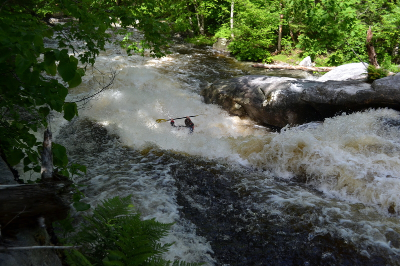
The river calms down a little before the biggest and most distinct rapid, Vlad the Impaler, named for the ominous undercut rock and cave on the bottom right of the slide. The river turns 90 degrees to the right before Vlad. Eddy and scout from the left.
Below Vlad the river slowly tapers down to class II. Paddle down about half of a mile to your car, which should be parked along side the river on Indian Hollow Road towards the confluence with the Westfield River.
Waterfalls (1)
Hazards & Portages (1)
Caution: The following locations may require scouting or portaging. Always check current conditions.
Difficulty
Class IV(V)
Length
3.3 mi
Rapids
0
1 Hazard
Access Points
Shuttle Info
Put-in where South Street crosses the river in Chesterfield, MA - just east of the intersection with Cowper Rd. Head northwest on South St. for 0.4 miles before turning left on Indian Hollow Road. Drive to the bottom of Indian Hollow Road (1.5 miles). Park at the end of the road.
Difficulty Classes
I Easy
II Novice
III Intermediate
IV Advanced
V Expert/Extreme
VI Unrunnable
Current Conditions
5-Day Forecast
Whitewater data from
American Whitewater
American Whitewater