SR 1242 to Cheoah/ US 129
Gauge Conditions
Runnable: 300.0 – 600.0 CFS
Reference gauge - USE WITH CAUTION. See write-up for more info.
Data from American Whitewater & USGS
Run Map
Run Time Estimate
Select put-in and take-out to estimate time.
Plan This Trip
See wind-adjusted speed maps, forecast planning, and detailed time estimates.
Sign in to generate an AI timing estimate for this run.
Whitewater timing varies with scouting, portages, and group pace. Use as a planning baseline.
Description
We've tried to hide Yellow Creek for quite some time, since it is arguably one of the best-kept secrets in Western NC.
But, since its gorge and land buffer are now at stake in the Tapoco relicensing (I think we've secured it from development, but still), we need to get the word out how wonderful this run really is.
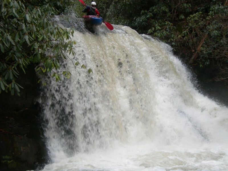
You'll often hear Yellow Creek called the easiest 500 fpm creek in NC. But that's not to say it's easy -- there's a slide bigger and steeper than Rapid Transit, there's a clean 20-foot vert, there are some wonderful boulder garden drops, and a truly nasty sieve. Overall, it's a solid IV-V, about the same difficulty as the Green if not just a hair easier. And it's really easy to miss when driving by the Cheoah since it is well hidden from the road due to its man-made constriction to fit Yellow Creek through the culvert. However, a short 15 yard hike upstream reveals a beautiful gorge. From there, you can either hike up to the 20 footer in rhodo hell for some park n' huck or drive up to put in all the way at the top, which I recommend.
Sounds great, right? But you know what the absolute best part of Yellow Creek is? It has a 15 square-mile drainage. Farmlands up at the top. It doesn't take much rain to get going and then it often runs for a day or two after everything else drops down. When I was last there, it was a good day after a big rain, Yellow was at a perfect level and holding while the Cascades had already long dropped out. And I'm sure it ran the day after that, too. Also, for one more nearby drainage comparison, that same day, Upper Santeetlah was also about as low as can be run.
It appears the most dependable way to anticipate if Yellow Creek is running is to check the Wauchecha AFWS rain gauge, which sits on the southeastern corner of the upper watershed. In the summer a minimum of 1 inch of rain 4-5 hours before putting on is needed. In the winter the same amount of rainfall would create a nice level.
Another way to anticipate when Yellow Creek is running is to use the Cheoah gage. To use it you must assume that there is no or minimal discharge coming from the Cheoah. The only other major tributary upstream of the gauge is Deep Creek, which is micro and drops fast (not runnable, by the way). When I see the Cheoah spike, that means Yellow and Deep are both going. Once Deep drops out of the curve, the gauge practically reads just for Yellow since it's so close. Unfortunately, we need more runs to be reported to determine accurate correlations, though I think 300 cfs as a low, 450 as mid, and 600+ as max is a good starting place. A significant limitation of the use of the Cheoah gage is that on a normal spike, by the time the water reaches Tapoco, the run is dropping fast. In addition, it can be hard to distinguish between Yellow Creek water and all the other water flowing past the Cheoah gage.
In any case, this creek is definitely worth checking out the day after a big rain. It should be good to go. And since you're in the area, go ahead and set shuttle at the bottom of the Cheoah, either near Tapoco Lodge or at the lake. If Yellow's running, then you can do a low-water tour of the Cheoah's steepest section.
Rapids in this Run (1)
Difficulty
Class IV-V
Length
1.3 mi
Gradient
375 ft/mi
max 600
Rapids
1
Access Points
Difficulty Classes
I Easy
II Novice
III Intermediate
IV Advanced
V Expert/Extreme
VI Unrunnable
Current Conditions
5-Day Forecast
Whitewater data from
American Whitewater
American Whitewater