Taylorsville Lake Road to Thurman Road (3.25 miles)
Gauge Conditions
Runnable: 1.3 – 2.0 FT
(requires a visual)
Data from American Whitewater & USGS
Run Map
Description
Video: http://vimeo.com/25889247
Visual Gauge: I recently found out that there is a visual gauge at the takeout on the downstream side of the bridge pillar. If it says 1.3 feet you are probabley too late since you now have to drive to the put-in. 1.5 should work as a minimum, and anything much over 2 should be reserved for experts.
5/26/11 Trip Report:
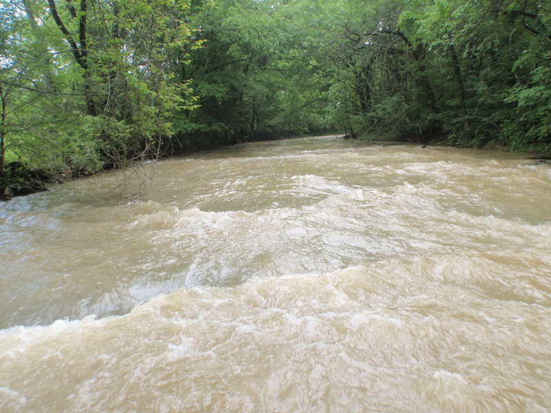
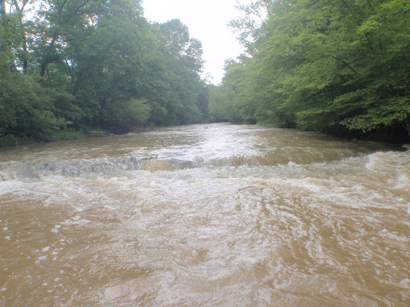
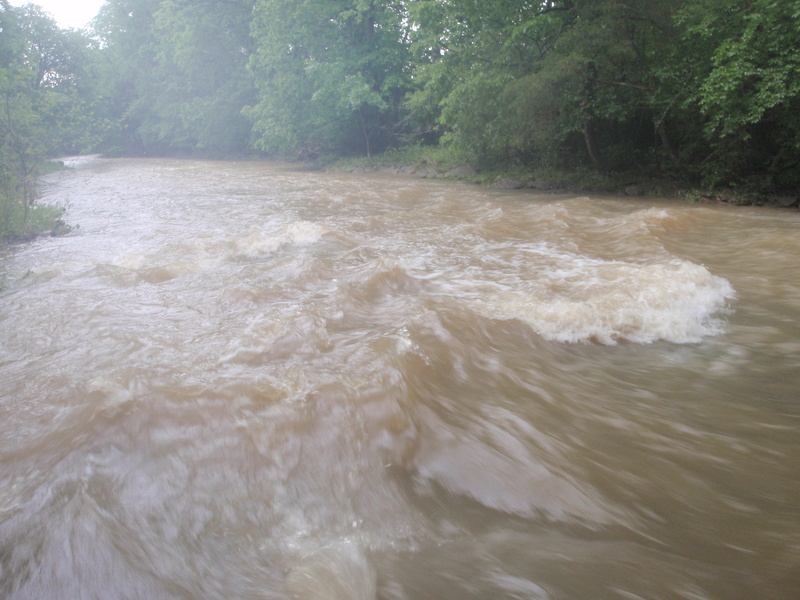
We had a big storm at 11:00 p.m the night before and I noticed Cedar Creek didn't hit it's max of 2.5 feet until 4 a.m. This gave me hope that running Cane Creek the next day might be possible. I wanted to put in at 9:00 a.m, but I didn't end up putting in until 12:30. At that time Cedar was at 1.3 feet and that was a good sign that this creek would be runnable since 1.3 feet is the minimum for Cedar Creek which is close by.
Our takeout was Thurman Road and our put-in was Taylorsville Lake Road. Both have A+ parking and creek access. Here is a map with how to park: http://maps.google.com/maps/ms?hq=http:%2F%2Fmaps.google.com%2Fhelp%2Fmaps%2Ftour%2Fmapleft.kml&ie=UTF8&hl=en&t=p&msa=0&msid=214505246309052560756.0004a1487dc1c78ac32dd&ll=38.164087,-85.461702&spn=0.02588,0.066047&z=15
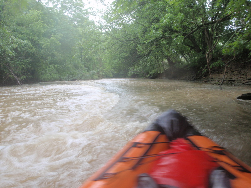
The adventure started out kind of slow with a few I+ drops and the creek was kind of scrapey. We picked up more water from Dunbar Creek, the creek got much wider, and things got much more interesting. We found a 1.5 foot ledge and had some fun on it. A few minutes later we found a slide rapid, but it wasn't much at the low level we were running it at and it wasn't very steep. A couple minutes later we found three ledges in a row and I have dubbed this Triple Ledges. A couple minutes later I saw a horizontal line on the creek and thought it was a waterfall, nope just a 3 foot ledge which I came up with a clever name for: Three Foot Ledge. Then a few minutes later I thought there was definitely a waterfall, nope just an awesome slide that made a frowning shaped surf wave, or you could run a three foot ledge by going river right. This place is like Back Run's clone, only the slide wasn't as good. I have decided to name the slide Back Run Slide Jr. A little ways further we found a nice 1 foot ledge on river right with a smaller diagonal ledge attached to it on river left.
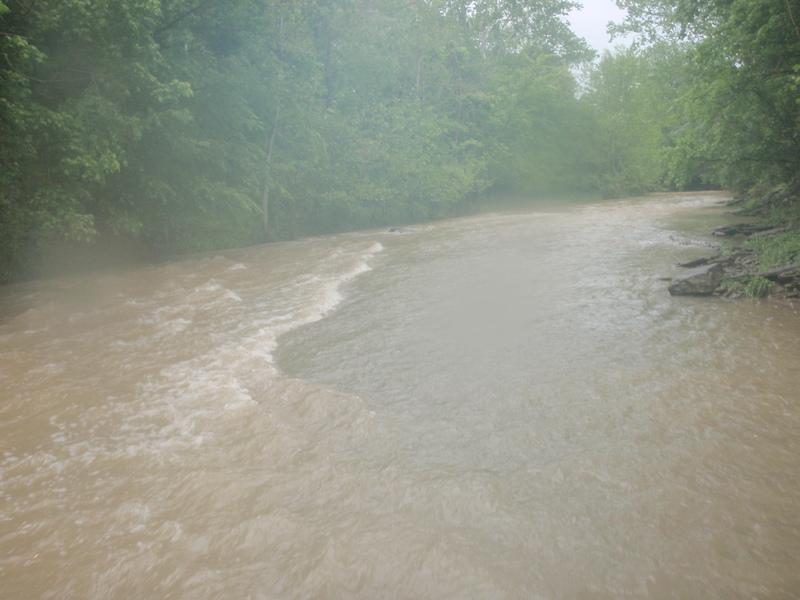
It started raining on us pretty good, but nothing as bad as what I experienced on Monday while I was on Floyds Fork.
We went past another feeder creek and the creek got much wider again.
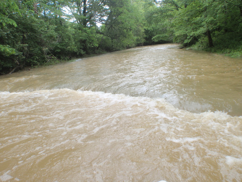
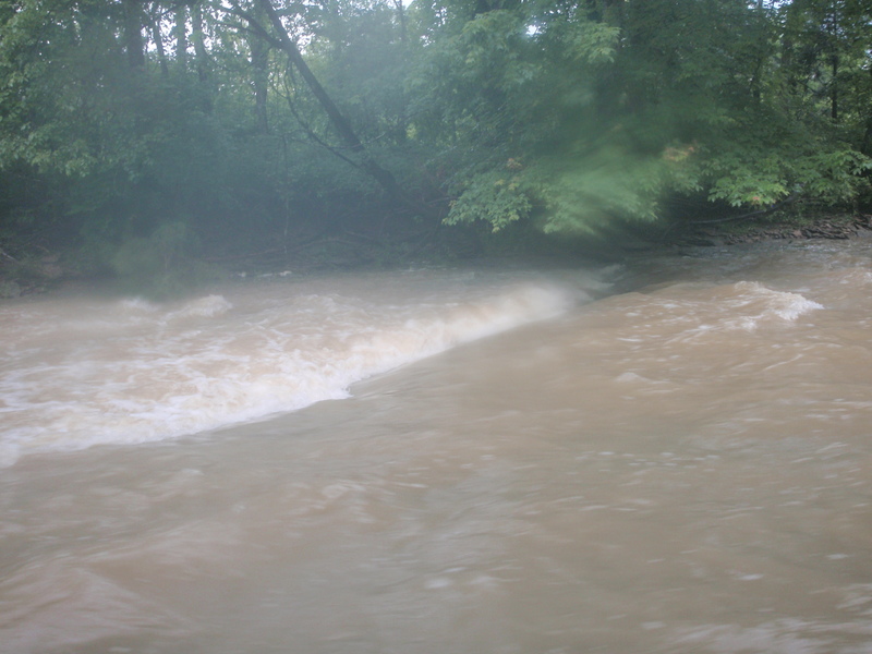
The creek calms down a bit as you go past 2 bridges: Routt Road (a nice fairly tall bridge) and then immediately after is an old abandoned looking bridge (not as tall as the other bridge but still decently tall). There were a couple islands we had to decided which way to go around and I think we always went right. It had been 15 minutes since I had last seen a significant rapid and then we found a great surf wave caused by a slide. I named this rapid 15 Minute Wave.
A few minutes later we came to a place with 2 back to back rapids. The first was a slide that needed a little more water to be any good but still had a few tiny WW waves. The second was a 1 foot slide style ledge on river right that kicked up some great surf. 5 minutes later we found a cool slide that made a small diagonal wave.
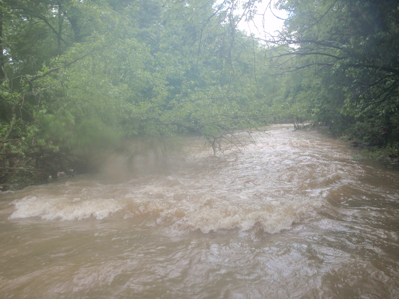
We came to an island, which I remembered from one of my scouting trips. The main creek goes river left, but I knew there were three ledges in a row if we went river right. The scenery was very cool the second we decided to go river right and it took only a minute before we came up on what I originally was going to call Triple Ledges but have now decided to call it Flash Flood Rapids.
The first is a small ledge with some surf. There used to be a strainer there but now it's gone. Next is a great ledge, I'll get back to it. The third ledge was really cool even at the low level it made for some great surf.
I have scouted a little bit of the left side of that island and found a pretty decent drop created from rock deposits. It might be 2 or more feet tall, and after that is about an 8 inch ledge that gets washed out at high water. I haven't scouted all of the left side and so there could be more but it didn't look like it from all of the flat water I saw on that side looking downstream at it.
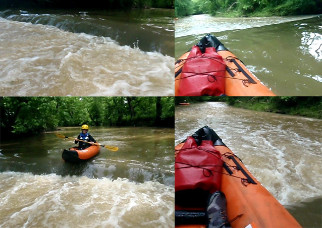
We started on our way but it stopped raining and I knew the adventure was almost over so we took the very long eddy service back to the rapid. Just for fun I started stacking rocks next to the third ledge to see if I could make it bigger. I was talking to my Girlfriend and when I looked back the wave was completely different. It looked like a glorious surf wave now. I noticed the rocks I was stacking all disappeared under water. I ran up to the second ledge to check it out and it was a class II+. That's when it really hit me: flash flood!
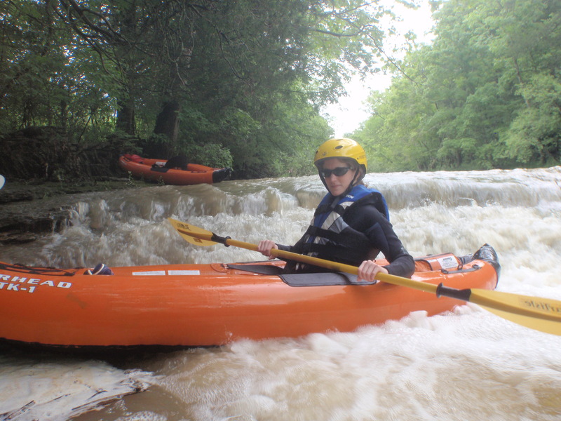
I ran back to the third ledge and it wasn't even a wave any more, it was washed out. I said we better go, and we snuck along the creek from one eddy to the next. They became harder and harder to find and there were lots of tree branches hanging over the creek making scouting rapids very tricky, but I still managed to get my beginner girlfriend from one eddy to the next. Finally they disappeared and she somehow got in front of me and ran a class II+ surf wave. She punched right through it and I did the same. Shortly after we came up on another bigger class II+ wave and we were able to sneak around it by going river right. I was sure it was the last rapid which shall now be named The Last Rapid. We caught an eddy and I made sure the bridge was safe and stayed to the far right since our takeout is on the right directly after the bridge. One of the pillars had a huge pillow on it and I got pretty nervous. I signaled my girlfriend to follow, and as she dodged some branches on river right she got too far left and was in the middle of the creek. She started paddling for river right, and I was yelling: paddle paddle paddle in fear she might get pinned against the pillar, and thank god she missed it.
I give this creek the same rating I would give Back Run/Broad Run, a II(III), the parenthesis is for high water.
I don't recommend running this at a high level due to the islands, tight turns, branches hanging on the sides of the creek which make strainers and obstruct visibility when trying to scout, trees growing on the sides of the creek which can pin you which makes catching eddys more dangerous, and lack of eddys. A medium level fine, raging, not a good idea at all. I feel the same way about Cedar Creek, and I always wondered exactly why the book A Canoeing & Kayaking Guide to Kentucky doesn't recommend running Boone Creek at a high level, and I think I now know why.
We never had to portage a single strainer, but there was a few we had to maneuver around. We scouted every turn for strainers using eddys that might not be there even at a medium level.
------------------------------------------------------------------------------
Spring 2013 Trip Report:
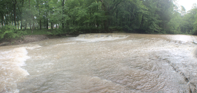
My brother and I tried to catch this creek, but we slept in and got on the creek late again. The takeout gauge said 1.3 feet so we thought it was a go, but by the time we drove to the put-in and blew up our duckies, the level dropped to under a foot. We drove right past the last good part of the bubble. It was even lower than last time, a total scrape but we made it down. I figured I would at least show my brother the creek. It turned out that first 1.5 foot ledge rapid is actually a dam. Just remember they can often look friendly WW wise, but look for mass quantities of bubbles after the dam. It might get bad at 2 feet or more.
NEW STRAINER: After you do the big slide there will be one more small diaganol ledge rapid, and then you will see a bunch of logs piled up on your right. Right after that there is a giant log spanning the entire creek. It was 2 feet above the current water level (3/4 a foot). You can see the giant pile of logs from far away and so portaging shouldn't be a problem. The level was low enough that we just went under it.
The stainer at Flash Flood Rapids is gone, so you don't have to worry about that one any more.
Rapids in this Run (2)
Playspots (11)
Hazards & Portages (2)
Caution: The following locations may require scouting or portaging. Always check current conditions.

Difficulty
Class II(III)
Length
3.3 mi
Gradient
19 ft/mi
Rapids
2
2 Hazards
Access Points
Difficulty Classes
I Easy
II Novice
III Intermediate
IV Advanced
V Expert/Extreme
VI Unrunnable
Current Conditions
5-Day Forecast
Whitewater data from
American Whitewater
American Whitewater