USFS Route 33 to Mulky Creek Camp - Toccoa river trib.
Gauge Conditions
Runnable: 750.0 – 10,000.0 CFS
Data from American Whitewater & USGS
Run Map
Run Time Estimate
Select put-in and take-out to estimate time.
Plan This Trip
See wind-adjusted speed maps, forecast planning, and detailed time estimates.
Sign in to generate an AI timing estimate for this run.
Whitewater timing varies with scouting, portages, and group pace. Use as a planning baseline.
Description
Cooper Creek starts as a shallow forest stream with gravel bars and the occasional downed tree. For the first few miles the primary excitement consists of small 1 foot or smaller rock ledges. The most significant danger on Cooper Creek are the ever present risk of deadfalls. There is no good access for the majority of the run so hiking off would be difficult.
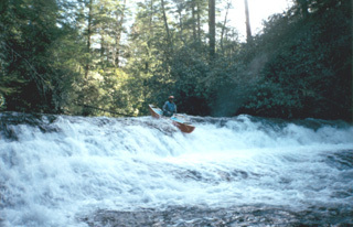
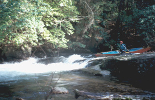
After a mile or so Cooper Creek begins to pick up speed and the maximum gradient for the creek is focused in one short section. There is a 16-foot sliding drop with the possibility of a big hole at very high water. This rapid is not very difficult but Grunch the single largest ledge closely follows it on the river. Grunch is a three-foot ledge with a possible pinning location on river left. The rapid was named for the sound boats make when running the river left line and slamming into the pinning rock. The river once again becomes an easy class II+ run with the occasional rapid. Corner Pocket is probably the most notable rapid outside of the slide and Grunch. The river becomes constricted and visibility is reduced possibly requiring a scout.
Below Corner Pocket the creek flows along for a few more miles and finally reaches road access again. Most boaters continue down for another half mile in order to pick up some good ledges and additional rapids.
If you are interested in looking at exciting class V waterfalls head down the road from the takeout and look at Sea creek falls.
Hazards & Portages (2)
Caution: The following locations may require scouting or portaging. Always check current conditions.
Difficulty
Class II-III
Length
9.7 mi
Rapids
0
2 Hazards
Access Points
Difficulty Classes
I Easy
II Novice
III Intermediate
IV Advanced
V Expert/Extreme
VI Unrunnable
Current Conditions
5-Day Forecast
Whitewater data from
American Whitewater
American Whitewater