W-1200 Road Bridge to Washougal River
Gauge Conditions
Runnable: ? – ? CFS
Approximate reading: This gauge is 11.3 miles away on Washougal. Use as a general reference only.
Data from American Whitewater & USGS
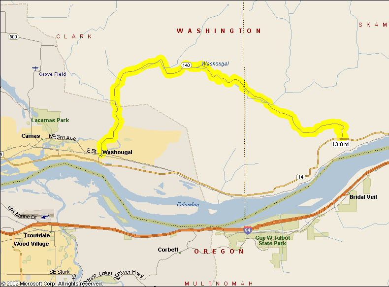
Run Map
Run Time Estimate
Select put-in and take-out to estimate time.
Plan This Trip
See wind-adjusted speed maps, forecast planning, and detailed time estimates.
Sign in to generate an AI timing estimate for this run.
Whitewater timing varies with scouting, portages, and group pace. Use as a planning baseline.
Description
W-1200 to Skamania Mines Road Bridge
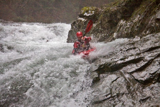
At the put-in, the river is small, narrow and shallow. Don't fret! Just around the corner the river consolidates and begins to bounce through some fun ledges and twisty turns. At high water this section really moves along and the currents are tricky in several places. After just over a half mile on the river, Hagen Creek enters on the right and the river drops to the left over Teakettle Falls. Be sure to catch an eddy at the mouth of Hagen Creek in order to scout Teakettle. Teakettle is a 2-part rapid with a shallow slide at the top and a powerful 10-foot ledge at the bottom. The right side of the ledge drops onto a rock and the left side drops into a sticky hole. If boaters decide to portage Teakettle there is a faint trail on the right. Boaters can lower boats to the base of Teakettle or continue downstream to less steep access to the river.
Below Teakettle the river mellows to Class 3 for several bends. Watch out for a tricky, narrow ledge drop at the end of a series of shallow slides. This drop tends to push boaters into the left wall so be ready! There is a sneak on the far, far right. After this drop, be on the lookout for mist rising from the next big drop, Cracken. There is a shallow eddy on the left close to the lip of this double drop. Be sure to catch the eddy. About 50% of boaters seem to run this big drop. The rest portage on the left to a 10-foot seal-launch to the base of the rapid or there is a faint path through the woods to the base of the pool below the rapid.
More boogie below Cracken leads to the Skamania Mine Roads Bridge that is an intermediate access point.
Skamania Mines Road Bridge to Main Washougal
Once boaters pass under the road bridge (Skamania Mines Rd, where the gauge is located), there is one rapid before the next commonly portaged rapid. Catch the eddy on the left at the lip of the drop just after a series of fast waves. This nasty ledge drops 10-feet into a boiling, narrow slot. I've heard this drop has been run but have never seen it personally. There is a fun seal-launch off the rocks on the left into the pool below the slot. Just around the next corner is a fun rapid with some big offset holes.
Fun rapids continue downstream including several fast rapids with big holes. Be sure to scout what you aren't sure of as some of these rapids have been known to have wood in bad places. After a quieter section with several houses on the banks and about a half mile below the confluence with Wildboy Cr. on the left, the pace picks up again with a 5-foot ledge hidden on a sharp right turn. There is an easy portage on the left which gets runnable when the water is high. The narrow slot on the left and the narrow, powerful slot on the right are rarely run on purpose. Once below this rapid take a second to appreciate the huge basalt wall towering over the rapid on the left.
From here the fast pace continues with several more fun rapids before things slow down near the Fish Hatchery. If you continue past the hatchery, be careful of the powerful weir at the far end of the hatchery and the big rapid just around the corner. Most boaters choose to run the rapid down a fun chute on the left to avoid the powerful center drop which has undercuts on both sides in the landing. From here the rapids gradually diminish all the way to the confluence with the main Washougal. Turn right and if you've got any energy left, there is a great playspot just downstream from the confluence. It's all flatwater from there to the take-out.
A note on flows:
_3000+ cfs on the Washougal gauge is a good benchmark to shoot for, but it's usually still runnable around 2,000 cfs if levels are still going up or the gauge hasn't started dropping yet. There isn't really a top end since it's just a reference gauge, but if the rain has stopped and the gauge is going down fast 10,000 isn't necessarily too much. In the end the Washougal gauge is just to let you know if it's worth checking the in-person gauge, which is located at the Skamania Mines Road bridge._
_On the in-person gauge, the rundown is as follows:_
_-6-7' is about as low as it has been reportedly run, you will notice how low it is._
_-10' is a worthwhile, but lowish flow._
_-15' is medium._
_-18' is getting pushy, but still medium._
_-20' and up is not an appropriate first-time flow for most boaters._
Rapids in this Run (2)
Waterfalls (1)
Difficulty
Class IV(V)
Length
7.8 mi
Rapids
2
Access Points
Difficulty Classes
I Easy
II Novice
III Intermediate
IV Advanced
V Expert/Extreme
VI Unrunnable
Current Conditions
5-Day Forecast
Whitewater data from
American Whitewater
American Whitewater