W Hartland Rd (Granville State Park) to Rt 20
Gauge Conditions
Runnable: 3.0 – 4.8 FT
Data from American Whitewater & USGS
Run Map
Run Time Estimate
Select put-in and take-out to estimate time.
Plan This Trip
See wind-adjusted speed maps, forecast planning, and detailed time estimates.
Sign in to generate an AI timing estimate for this run.
Whitewater timing varies with scouting, portages, and group pace. Use as a planning baseline.
Description
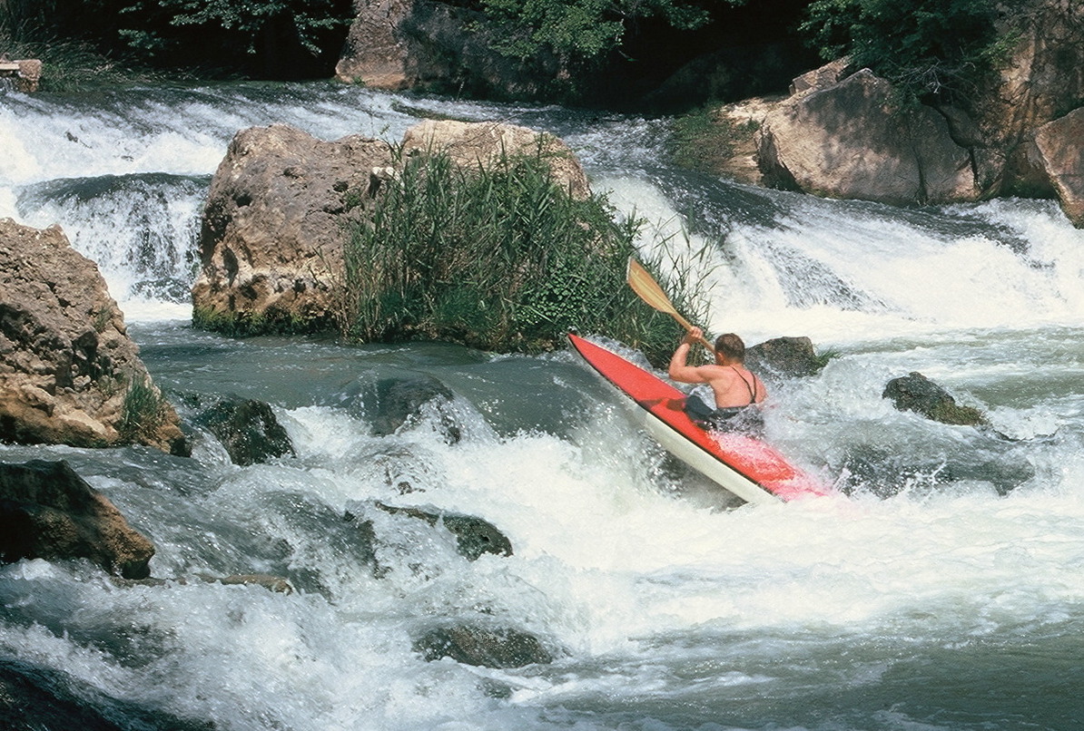
The usual put-in is at the head of the rapid just above the bridge. If you’re not comfortable with this rapid it is suggested that you take out now because the river gets more difficult downstream. After Bridge Rapid it’s class III boogie water until you get to a large boulder on river left. Right behind the boulder is Seven Foot Falls which is a near vertical drop into a large pool. It’s best to stay right as you go over the drop.
Shortly after Seven Foot Falls is Bow Pin Rapid which is worth scouting. In the old days 13-foot boats use to pin their bows if they ran straight over the drop. The best plan is to angle your boat to the right as you go over or cut hard left and bounce over the rocks.
Right after Bow Pin is Bumpy Slide which is pretty bumpy. There’s no problem with it unless you’re paddling a pointy boat. Who uses pointy boats in a creek now-a-days anyhow?
Next up is a couple of river wide ledges about six feet high that should be scouted. If you run them wrong you could get recirculated. Right after the second ledge is a short, tight rapid that ends right above Michaud Falls. At the top of Michaud Falls there’s a ledge outcropping on the left and a giant boulder in the center making the entrance only a few feet wide. The water drops several feet and lands on a steep slope that’s full of rooster tails and holes. If you run straight over the drop you will be pushed left and slammed against some rocks. The preferred route is to enter the narrow slot from the left and just miss the boulder as you go right. You’re now over half way down the river.
Hazard Warning: Around 100 yards or so below Michaud Falls is a low ledge on river right that’s almost river wide with an easy passage on the left. This ledge has a very serious hydraulic. It claimed the life of a very skilled paddler who knew the run well. Click here for the accident report.
Below here the river gets steeper and tighter almost all the way to the end. Near the end, the river opens up a bit and gets a bit easier. Near the start of this section are two short, shallow slides that have keepers at the bottom. Many people have been trapped there and had to exit their boats.
After the easy section is the last major rapid which is to the right of an island and is very steep. The route is to enter on the right and get left as soon as you can. Below here there’s a class III rapid which ends at the gaging station which is the take-out.
DO NOT paddle below the gaging station. The property belongs to the Connecticut MDC Water District for a water supply and is part of their watershed. They don’t object to our paddling the river as long as we don’t paddle past the gaging station. Please don’t blow it for the rest of us by paddling any farther.
Daniel Holzman shared in 2002:
This is a remote, very beautiful run through a mature coniferous forest. Recommended absolute minimum level is 2.7 on the gage at the takeout dam, although I have banged down it at 2.3 on the gage. The river below the dam is posted off-limits by Connecticut because it is a water supply. It isn't worth the extra 150 feet of whitewater to run the dam and risk alienating the authorities.
Rapids in this Run (1)
Waterfalls (1)
Difficulty
Class V
Length
2.6 mi
Gradient
130 ft/mi
Rapids
1
Access Points
Shuttle Info
From Westfield, MA, take Rte. 202 South to Rte. 57 West. Follow 57 through Granville and West Granville. About 11 miles from 202, Rte. 57 crosses Hubbard Brook. Park in the pulloff just after crossing the river and put in here.
Takeout: head East on Rte. 57 and take your first right onto West Hartland Road, toward Granville State Forest. Continue through the state forest, crossing Hubbard Brook to Rte. 20. Turn left onto Rte. 20 West and continue until it crosses Hubbard Brook. Just after the brook is a gated road on the left, which follows Hubbard Brook upstream. The takeout is just up this road, by the USGS gaging station.
Difficulty Classes
I Easy
II Novice
III Intermediate
IV Advanced
V Expert/Extreme
VI Unrunnable
Current Conditions
5-Day Forecast
Whitewater data from
American Whitewater
American Whitewater