W. Wildcat Rd to Lake Burton
Gauge Conditions
Runnable: 500.0 – 5,000.0 CFS
Upper limit for best boatability uncertain. Please help your fellow boaters with a comment or report.
Data from American Whitewater & USGS
Run Map
Run Time Estimate
Select put-in and take-out to estimate time.
Plan This Trip
See wind-adjusted speed maps, forecast planning, and detailed time estimates.
Sign in to generate an AI timing estimate for this run.
Whitewater timing varies with scouting, portages, and group pace. Use as a planning baseline.
Description
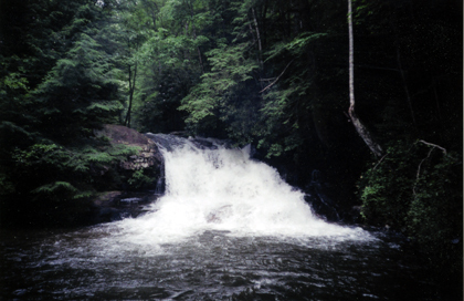
There are really two different runs on Moccasin Creek. One option is to drive all the way to the end of W Wildcat Rd. and put in on the headwaters near a wildlife opening. The stream is open and shallow but surprisingly deep in spots. This option take lots of water and has some disadvantages including LOTS of trees and one huge waterfall that proably must be walked. There is a nice trail and campsite on the river right. The second and more realistic option is to carry up the Hemlock Falls trail for a mile or more. The trail degrades quickly after Hemlock Falls but there are plenty of difficult and large rapids in this section. Most boaters will probably take out at the WMA trailhead but you can boat all of the way down to Lake Burton. There is a small dam for the trout farm ten yards above the final road crossing. Please walk around the dam to keep the Park folks happy. Remember this is a popular trout fishing creek.
Waterfalls (1)
Hazards & Portages (1)
Caution: The following locations may require scouting or portaging. Always check current conditions.
Difficulty
Class III-IV(V+)
Length
4.3 mi
Rapids
0
1 Hazard
Access Points
Difficulty Classes
I Easy
II Novice
III Intermediate
IV Advanced
V Expert/Extreme
VI Unrunnable
Current Conditions
5-Day Forecast
Whitewater data from
American Whitewater
American Whitewater