Waterworks Park to Homer City
Gauge Conditions
Runnable: 245.0 – 1,500.0 CFS
Data from American Whitewater & USGS
Run Map
Run Time Estimate
Select put-in and take-out to estimate time.
Plan This Trip
See wind-adjusted speed maps, forecast planning, and detailed time estimates.
Sign in to generate an AI timing estimate for this run.
Whitewater timing varies with scouting, portages, and group pace. Use as a planning baseline.
Description
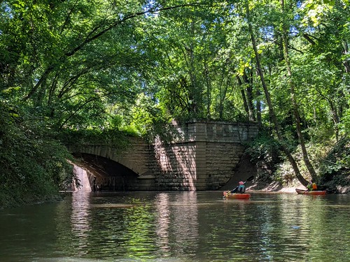
Overview: This is a largely quiet creek excellent for kayaking with approximately 4 places with Class I riffles and one class II hydraulic (after Rt 119 bridge, can be avoided). The first half of this creek is mostly through wooded areas; the second half has some highway noise. The end of the trip has you float through homer city.
Put in:
Waterworks Park, Indiana PA, 15701 (small park off of Waterworks Road, Indiana PA). Once you park, the carry in is about 50 feet right in front of the parking lot past the pavilion.
Take out (6 miles later):
Homer City PA, there is a small park where some community garden plots are and a small parking lot. This park is 1/4 mile south east of Ideal market on Water street. There is a trail to the river.
There is no shuttle service available.
Gauge: Use USGS water gauge for Graceton, PA.
https://waterdata.usgs.gov/usa/nwis/uv?03042500
Two Lick Creek is enjoyable at water gauge 3.0 and higher, although there are some shallow spots.
After crossing the Old Route 119 Highway south bridge (approximately mile 5 of the 6 mile trip), there is one class II hydraulic hole in the center of the river. Easy to run straight through; no obstructions or stones surrounding it. This hydraulic is present if the water level is 3.2 or higher, typically.
Around mile 4 of the trip, as you are along Route 119, the river splits. The left hand way is blocked entirely by a fallen tree, but you can portage around with a 30 foot carry. The right hand side has a fallen tree on half of the river; if you keep left you can avoid this hazard. Given this obstruction, I would not recommend paddling this river over 4.0 feet unless you have scouted it in advance.
Note: There is a low-head water dam hazard at the Homer City power plant (mile 7 of this river trail). Trail is kayakable beyond the take out point listed above, but you need to portage around the dam.
Playspots (1)
Difficulty
Class I-II
Length
6.5 mi
Rapids
0
Access Points
Difficulty Classes
I Easy
II Novice
III Intermediate
IV Advanced
V Expert/Extreme
VI Unrunnable
Current Conditions
5-Day Forecast
Whitewater data from
American Whitewater
American Whitewater