Whitcomb Island Rd to Johnson
Linked via: Proximity 99% confidence Synced 6mo ago
Gauge Conditions
Runnable: 1,300.0 – 2,800.0 CFS
Dependent on if the gauge is rising or dropping. 1300-1700 and dropping often corresponds to a level of somewhere between 1-1.5 (minimum to low).
Data from American Whitewater & USGS
Run Map
Run Time Estimate
Select put-in and take-out to estimate time.
Unlock Advanced Trip Planning
See wind-adjusted speed maps, forecast planning, and detailed time estimates.
Sign in to generate an AI timing estimate for this run.
Whitewater timing varies with scouting, portages, and group pace. Use as a planning baseline.
Description
The Gihon can be thought of as two sections, the upper and the lower. These are separated by a mile of scenic flatwater through rolling Northern Vermont hills. For a short run you can do just the lower, but the upper is certainly worth the flatwater.
Upper section:
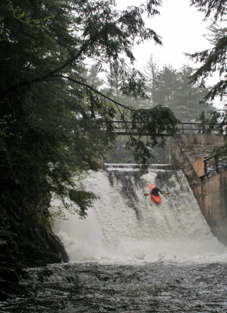
Starts with a 25ft dam. This is clean and incredibly fun. Folks being led down for their first time are rarely allowed to scout (it is much more fun this way). Check the bottom for wood and then slide over a few boat widths to the left of the center abutment. If the level is above 3 on the painted gauge the hole at the bottom will start to get a bigger until the point where you won't want to run it.
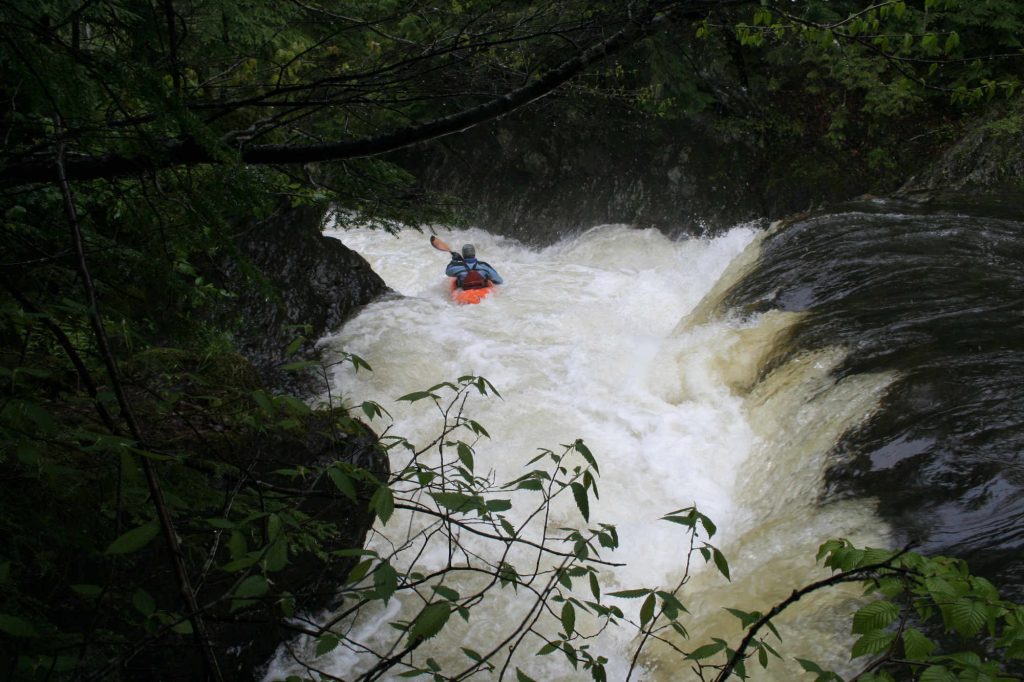
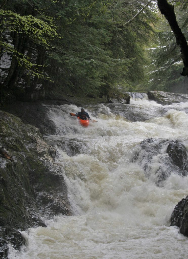
Several class IV ledges/rapids follow in a beautiful gorge-like setting. The culmination is Mustang, a big 3 stage rapid that plunges into a narrow gorge. The left side is a dangerous looking crack and should be avoided. The hole at the bottom is generally flushy but gets big as the level rises. After this rapid is some gentle run-out and then the start of a mile or so of flatwater through rolling farm fields.
Lower section:
Begins at the obvious horizon line. This two stager is referred to as Bed-Head. It is the hardest rapid on the lower and can be portaged on the left. Following are a half dozen or so class IV ledge rapids. You can paddle all the way into town or take out below the rapid after the powerhouse covered bridge.
Water:
The guage listed here is on the nearby and large Lamoille. The Gihon rises quicker and drops quicker, so when the level is coming up or down on the Lamoille the Gihon is likely a step or two ahead.
There is a painted gauge on the RR abutment of the powerhouse bridge.
1 is minimum
1-2 is low
2-3 is medium
3-3.5 is medium high
3.5-4 is high (some of the rapids start to close out)
4+ is higher than recommended.
Rapids in this Run (1)
Waterfalls (4)


Difficulty
Class IV(V)
Length
3.5 mi
Rapids
1
Access Points
Shuttle Info
Take 100C North out of Johnson.
Take out:
At the covered bridge 1/4 of a mile up the road.
Put in (lower):
Approximately 1 mile up from the take out turn right onto Sinclair road (just before crossing the river). There is a small pull off next to the river about 1/10 of a mile up the road here, across from a small sugar shack. If it is spring and they are there please make sure to talk to them to make sure it is okay you use this pull off.
Put in (upper):
Do not turn on Sinclair road - instead continue across the river and up 100C for another mile or two until you see Whitcomb Island Road on the right. Take this Whitcomb Island Road until you cross the river again and come to an immediate T. There is a pull off on the left directly above the bridge, please do not block the fire hydrant, and be discrete/considerate here as there are houses and families around.
Difficulty Classes
I Easy
II Novice
III Intermediate
IV Advanced
V Expert/Extreme
VI Unrunnable
Current Conditions
5-Day Forecast
Whitewater data from
American Whitewater
American Whitewater