How's Your
River
×
Explore
Explore Map
Water Bodies
Gauges
Access Sites
Tidal Stations
Whitewater
Pricing
Login
Sign Up
Hazard Warning:
Hazard information may be user-submitted and unverified. Conditions change frequently. Always scout rapids and obstacles yourself.
Whitewater
Utah
Colorado - 17. Moab to Green River Confluence
Confluence
Rapid
UT
Confluence
Colorado - 17. Moab to Green River Confluence (UT)
Monitor this Rapid
Water Body
This Run
Map
Other Rapids
Gauge
Weather
Directions
Gauge Conditions
Colorado River at Potash, UT
Upstream
Primary
Runnable: 1,000.0 – 20,000.0 CFS
Data from
American Whitewater
&
USGS
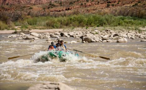
Photo
Photo courtesy of
American Whitewater
Description
Confluence of the Green and Colorado Rivers.
Location
Radar
Counties
Cell
Verizon
AT&T
T-Mobile
Dark
Satellite
Terrain
Other Rapids on This Run (5)
Rapid
N/A
Moab Bridge Boat Launch
0.0 mi
Rapid
N/A
Potash Boat Ramp
17.2 mi
Rapid
II
The Loop
53.6 mi
Rapid
II
The Slide
63.2 mi
Rapid
N/A
Spanish Bottom
67.0 mi
Type
Rapid
Difficulty
Class N/A
Mile Marker
64.8 mi
Directions
Navigate
View Full Run
17. Moab to Green River Confluence
Colorado
II
65.0 mi
Current Conditions
5-Day Forecast
Whitewater data from
American Whitewater
Confluence