Rapid
ID
Rattlesnake Cave (RR)
Save this feature with the run it belongs to.
Gauge Conditions
Runnable: 700.0 – 10,000.0 CFS
May be low for a raft.
Data from American Whitewater & USGS
Photo
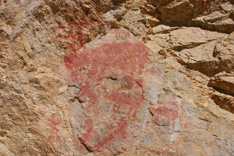
Photo courtesy of American Whitewater
Description
Rattlesnake Cave is a day-use site and not open for camping. The overhung wall displays and impressive collection of pictographs. To ensure you don't miss it, use the higher upstream pull in and walk down along the shoreline on river right. An alternate pull-in is an option closer to the pictographs but it requires a precise ferry from where the main flow is on river left over to a small landing on river right.
Location
Interactive river map
Loads as you approach this section.
Other Rapids on This Run (20)
 Rapid
N/A
Rapid
N/A
Boundary Creek
Rapid
II
First Bend Rapid
 Rapid
IV
Rapid
IV
Murph's Hole Rapid
Rapid
N/A
Teepee Hole Camp (RL)
Rapid
N/A
Cable Hole Camp (RL)
 Rapid
II
Rapid
II
Pinball Rapid
Rapid
N/A
Gardell's Hole Camp (RR)
Rapid
III
Sulphur Slide Rapid
 Rapid
III
Rapid
III
Ramshorn Rapid
Rapid
III
Hells Half Mile Rapid
Rapid
IV
Velvet Falls
Rapid
N/A
Boy Scout Camp (RR)
Rapid
N/A
Big Bend Camp (RR)
Rapid
N/A
Trail Flat Camp (RL)
Rapid
II
Avalanche Atoll Rapid (aka Upper Chutes)
Rapid
III+
The Chutes Rapid
Rapid
N/A
Elkhorn Bar Camp (RR)
Rapid
N/A
Saddle Camp (RL)
Rapid
N/A
Boot Camp (RR)
Rapid
IV
Powerhouse Rapid
View Full Run
2 - Boundary Creek (Dagger Falls) to Salmon River (Cache Bar)
Salmon, Middle Fork
III-IV
95.0 mi
Current Conditions
5-Day Forecast
Whitewater data from
American Whitewater
American Whitewater