2. Cross Mill bridge road to Franklin (Lower Winni)
Gauge Conditions
Runnable: 400.0 – 2,800.0 CFS
Data from American Whitewater & USGS
Run Map
Run Time Estimate
Select put-in and take-out to estimate time.
Plan This Trip
See wind-adjusted speed maps, forecast planning, and detailed time estimates.
Sign in to generate an AI timing estimate for this run.
Whitewater timing varies with scouting, portages, and group pace. Use as a planning baseline.
Description
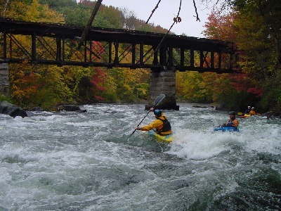
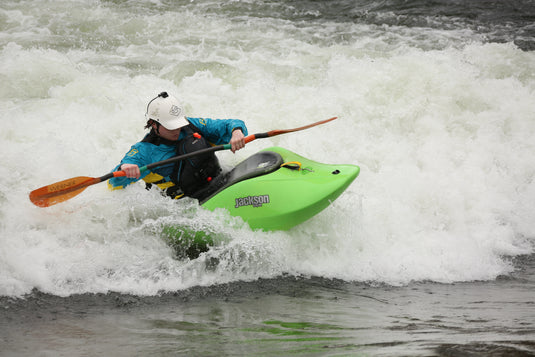
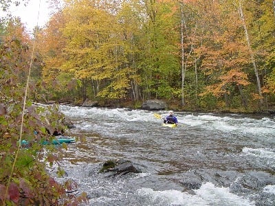
The lower Winnipesaukee (The 'Winni') is a popular run in southern New Hampshire, just 90 minutes from Boston and offers excellent paddling at nearly all flows throughout the year. Clear water, quality rapids, and an easy shuttle provide for plentiful laps that are appropriate for intermediate and advanced boaters alike.
As of late 2017, there is a new parking area available at the putin on Cross Mill Road, made by the generous support and activity of American Whitewater.
Winnipesaukee River Days is an annual whitewater festival in downtown Franklin typically held in mid to late June. The festival will coincide with a recreational release on both sections of the Winni. Come and support the town and paddling community. More information on events can be found at the Winni RiverDays website.
Winnipesaukee Recreational Plan: Info at: Winni Proposal We need backing on this from the paddling community. We are looking for summertime releases on this river and this event will help publicize our request.
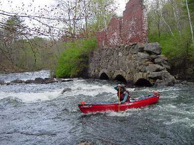
The Winnipesaukee river was a heavily used industrial river in the early 20th century. The upper Merrimack Valley was considered the bread basket of New Hampshire about a century ago. Wheat and other grains grown in the Franklin region was transported to several grist mills that were built on the banks of the Winnipesaukee river. Dams were built to harness the mechanical power for turning grinding wheels that turned the grain into flour. There are still several grinding stones that can be seen along the river bank. They are about 4 feet in diameter with a hole in the middle and what looks like spokes ground in the granite stone. Those mills are now mostly gone with trees replacing the scenery. The dams were eventually knocked out one by one by the force of great floods. There are at least 7 dam sites along this short stretch of river. In the early 90's local boating clubs organized several cleanup days during low water in August. Log cribbing, rebar, and other trash were removed to make for a safer run.
This river continues to draw more boaters every year. It is also the location for the traditional New Years Day run organized by the Merrimack Valley Paddlers. An event that always gets alot of local press.
### Technical info
```
Put in elevation........390'Take out elevation......290'Total drop..............100'Average drop/mile.......80'Distance................1.25 milesRiver width average.....60'River geology...........Small to medium schist and granite boulders, many of which are unatural blocks cut for buildings and dams. River water quality.....Good in spring fair latter in Summer, clarity fair to good.Scenery.................Fair, remains of early 20th century industrial age being reclaimed by forest, up to seven old dam sites with some log cribbing and some rebarr, two delapated factories.Wildlife................Deer, Weasels, Merganzers, Blue herons.
```
## Trestle View Park Established 12/20/07
After many years of planning, fundraising and meetings the town of Franklin New Hampshire has finally completed the new riverside park at the Lower Winnipesaukee River takeout. The park located on 2 acres of land at the takeout of the lower Winnipesaukee River features a river level take out ramp, grass, trees, and a 11-1/2 ton 15 foot diameter industrial flywheel that was used in a mill just a quarter mile downstream from the park. This flywheel is the centerpiece of the park and will probably become the most recognized landmark in Franklin in the near future. A bathroom/changing room is now complete.
The park is a culmination of wide ranging efforts from the town of Franklin, The Friends of the Winnipesaukee, the Grevoir family, American Whitewater and the Merrimack Valley Paddlers. It was built on land donated by the Grevoir family who are the owners of Grevoir Furniture, which abuts the park. Fundraising efforts for the park continue, they are having a fundraiser to help pay for the town's portion of the new park.
For an overall river map click here:
Winnipesaukee map
Rapids in this Run (4)
Playspots (2)
Hazards & Portages (1)
Caution: The following locations may require scouting or portaging. Always check current conditions.
Difficulty
Class III+
Length
1.2 mi
Gradient
80 ft/mi
max 90
Rapids
4
1 Hazard
Access Points
Shuttle Info
## Directions
### Put in
Interstate 93 from southern NH north take exit 19.
At the end of the ramp take a left on route 132.
About 1.2 miles, take a left at the traffic light at the intersection of state route 3, 11.
About 1.8 miles look for Franklin savings bank on the left.
Take a left after the bank on Cross Mill bridge road.
1/4 mile to the put-in at the bridge over the river.
From Interstate 93 north, take exit 20.
Take a right on state route 3, 11.
Approximately 3 miles to Cross Mill bridge road.
### Take out
Head back to state route 3, 11 and take a left.
1-1/4 mile park on the right just after the bridge over the river.
Difficulty Classes
I Easy
II Novice
III Intermediate
IV Advanced
V Expert/Extreme
VI Unrunnable
Current Conditions
5-Day Forecast
Whitewater data from
American Whitewater
American Whitewater