A) Moore Park to Vogues Rd (up to 8.5 miles)
Gauge Conditions
Runnable: 150.0 – 600.0 CFS
Likely too low for reasonable whitewater trip. (New gauge! We need your input to establish/refine best flows! Add a comment or report.)
Data from American Whitewater & USGS
Run Map
Interactive run map
Loads as you approach this section.
Run Time Estimate
Select put-in and take-out to estimate time.
Plan This Trip
See wind-adjusted speed maps, forecast planning, and detailed time estimates.
Sign in to generate an AI timing estimate for this run.
Whitewater timing varies with scouting, portages, and group pace. Use as a planning baseline.
Description
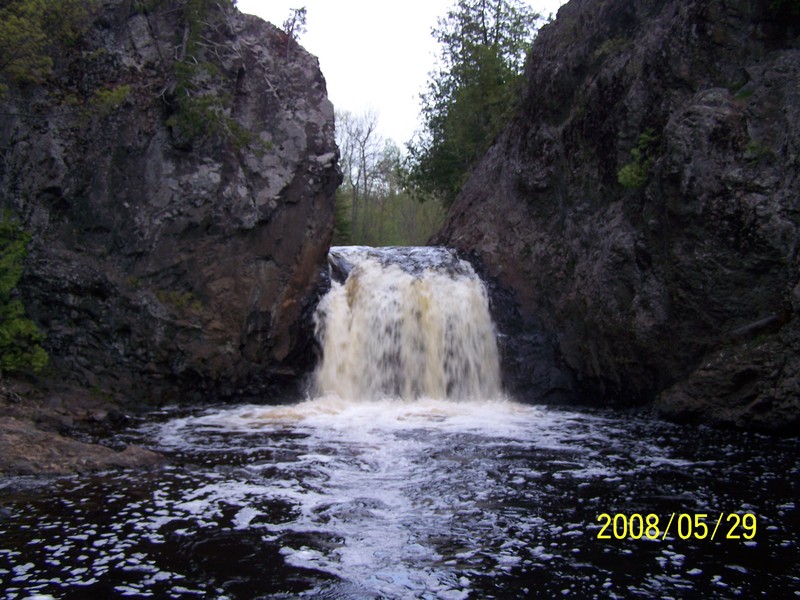
The Tyler Forks features boulderbed rapids. interspersed by sections of alder swamp, with several steep bedrock drops. Wren Falls (towards the end of the reach) may be one of the most scenic small falls in the state.
This reach begins with the "dells" of the Tyler Forks (local name unknown) which is reached by carrying upstream from the end of Moore Road. The river rapidly drops 40+' through a sequence which begins with fast class III feeding into a stepped ledge of 8'-10' and finishing with a fun drop through a rockwalled canyon/dells. This is the most technically challenging drop on this reach. Those who don't wish to run this should put-in at the Hwy 77 bridge as there is only flat water (and likely some deadfall/snags) between the bottom of this drop (at Moore Road) and the bridge.
From Hwy 77, the current picks up again through read-and-run boulderbed with one ledge of about 4'. After about a mile and three quarters, things start to slow down as the river enters a section of moving water through alder swamp. When the current starts picking up again, be aware that you are approaching Wren Falls. Wren is a rolled lip vertical of about 10'-12', dropping between vertical rock walls into a deep pool, a very beautiful site and great photo op. The falls approach is pretty straightforward, though you will want all the speed you can muster to launch and avoid the hole at the base. Below Wren there is about a half mile of class II followed by a short stretch of moving water to the Vogues Rd take-out.
Rapids in this Run (17)
Rapid
Moore Road
Rapid
Hwy.77 / USGS sampling site
Rapid
III
First ledge
Rapid
III
Second ledge/slide
Rapid
Prelude to Third Movement
Rapid
Third Movement
Rapid
III
Slide
Rapid
II+
Zig-Zag Chutes
Rapid
Confluence, Erickson Creek
Rapid
Confluence, Javorsky Creek
Rapid
II+
Chute
Rapid
II+
Tripping Ledges
Rapid
Light boulderbed
Rapid
Rocky Outcropping
Rapid
II+
Tailfeathers
Rapid
III
Rocky Chute
Rapid
Last Hurrah
Waterfalls (1)
Difficulty
Class II-III+(IV)
Length
7.8 mi
Gradient
37 ft/mi
max 81
Rapids
17
Access Points
Shuttle Info
The Tyler Forks is located about 8 miles east of Mellen on Hwy 77. About 0.8 miles before (west of) the Hwy 77 bridge is Moore Park Rd. This is not signed but is the only road south this close to the bridge. Drive down Moore Park Road for about a mile and a half to the end and hike up the hill to the right for the "dells".
**To get to the take-out**, return to Hwy 77 and turn right. Cross the bridge over the Tyler Forks and in 1.5 miles, look for Casey Sag Road. Turn left on Casey Sag Road, staying on the main road, bearing to the left after about five miles as the road becomes Sullivan Rd and (after another two miles) Vogues Rd. Once you reach Vogues Rd, it is only another quarter mile to the river. These are logging roads and for the most part don't have signs. High clearance and/or 4WD may be necessary anytime that snow and/or mud may be encountered.
Difficulty Classes
I Easy
II Novice
III Intermediate
IV Advanced
V Expert/Extreme
VI Unrunnable
Current Conditions
5-Day Forecast
Whitewater data from
American Whitewater
American Whitewater