Anneewakee Road to GA Route 166
Gauge Conditions
Runnable: 800.0 – 4,000.0 CFS
Data from American Whitewater & USGS
Run Map
Description
## Gauge Description
Look for Sweetwater Creek to be runing 800 cfs and rising or locally heavy rain of at least 1.25 inches.
Annewakke will drop back down to nothing in a matter of hours. The sweetwater gauge is used to show if Annewakkee has gotten enough rain to check, but sweetwater holds water for days.
River Description:
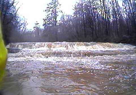
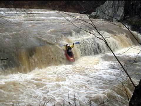
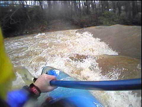
The put-in is on Annewakee Road and there's good parking on the downstream side of the bridge. There is a great but grabby playspot right at the putin. The creek picks up quickly and gets your blood pumping with a few fun class 2's. Then it's flat for a bit... then the horizon line. The first large drop is about 9 feet and reminds me of the Upper Tellico. It's a safe drop if run left of center, look out for the "Hole of Doom" on the center-right after the main drop. It probably wouldn't kill you but you'd probably swim out. It's easy to miss.
Next is a short class 2-3 section that runs through a power line cut. There are some great waves here! You used to be able to drive (4x4 only!) out the power lines to this spot but thanks to vandals the entrance has been cabled off.
Be VERY careful not to just drop over the next horizon line immediatley after the power lines, you could get REALLY hurt. The next drop is about a 12 footer and really kicks. The river left side is an almost certain pin. The water runs down a slide and hits a jagged rock and forms a kind of mini Oceana with a not-so-forgiving "Thing". The left of center line has rocks at the bottom so that's no good. The center line seems the way to go, angling to the right a bit.. Be careful not to get sucked back into the hole at the bottom or you're swimming. The right side could be OK but we didn't run it. The far right side is a plunge into the abyss and we didn't know what was down there so it's still a mystery. The portage is on river right.
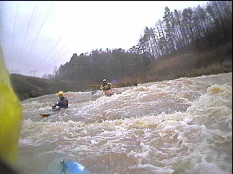
After the big drop there is a 1/4 mile of class 3 water with a fun double drop that's a strong III+ at normal levels and turns into solid 4 at high flow. After this, the river takes a sharp turn to the right and slows down for a mile or so. Then it takes a hard turn to the left and cuts through another ridge, the action picks up here again and a few class 2's and 3's appear but nothing like the upper section. A bit of flat water gets you to the take out on Ga 166.
This is a great run! We were very impressed. The water quality is not great but the rapids are! As of March 2002 there were a few dead falls that needed to be carried over but no "strainers of doom".
FYI, Sweetwater reached almost 4 feet that day after rain the night before and Annewakee was at a comfortable level. It could certainly be done higher, but not much lower. Total rainfall for the previous night was about 1.2 inches and it was still raining lightly when we put on at 2pm. It will take you between 1.5 to 2.5 hours to make this run barring any epic adventures.
Waterfalls (2)
Playspots (2)
Hazards & Portages (1)
Caution: The following locations may require scouting or portaging. Always check current conditions.
Difficulty
Class II-III+(IV)
Length
3.7 mi
Gradient
30 ft/mi
max 100
Rapids
0
1 Hazard
Access Points
Difficulty Classes
I Easy
II Novice
III Intermediate
IV Advanced
V Expert/Extreme
VI Unrunnable
Current Conditions
5-Day Forecast
Whitewater data from
American Whitewater
American Whitewater