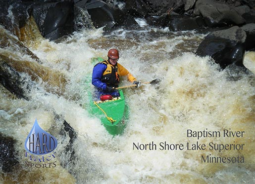
B) Eckbeck campground to Lake Superior (4 miles)
Gauge Conditions
Runnable: ? – ? CFS
Approximate reading: This gauge is 20.2 miles away on Baptism. Use as a general reference only.
Data from American Whitewater & USGS
Run Map
Run Time Estimate
Select put-in and take-out to estimate time.
Plan This Trip
See wind-adjusted speed maps, forecast planning, and detailed time estimates.
Sign in to generate an AI timing estimate for this run.
Whitewater timing varies with scouting, portages, and group pace. Use as a planning baseline.
Description
Click this link for a fine *YouTube Video of the run*
From the Forest Service campground, easy boulder garden paddling leads about a quarter mile to a small canyon with a fine III+ drop, leading to a good recovery pool. Easy paddling for the next mile and a half leads to the next significant drop. Increased gradient leads to a large boulder (just right of center) which can be run to either side.
A brief paddle brings one to an irregular short ledge, followed by boiling 'funny water', as the river is immediately diverted ninety-degrees to the left.
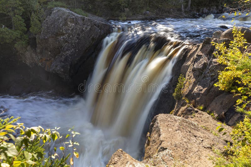
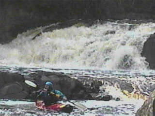
Be prepared to take out a short distance downstream, as a horizon line looms, and the thundering of *Illgen Falls* is heard. Small diagonal ledges lead in to this 35' vertical drop, which has been run routinely since the 70's. A narrow 'goat-trail' portage for the less adventurous (?) clings tenuously to the river left rim, over the boiling cauldron at the base of the falls. Illgen Falls can be run as low as 200 cfs, but 300 to 450 cfs is optimal! Above 500 cfs there are serious consequences for being offline!
Resume paddling for a short distance, getting out river left above the *Superior Hiking Trail* footbridge. *High Falls*, a 50-60' vertical drop, landing almost uniformly shallow, has been survived (with broken bones) by a hiker who was swept over it. Boaters will follow the trail to a boardwalk down to the river below the falls.
The next significant drop, *Two Step*, consists of a 12' ledge (boof river left), followed by a short recovery area, then a second ledge. Center river drops more gradually, across irregular bedrock, and into a particularly sticky hole. The usual route is tight right, through a couple easy waves, almost brushing the vertical rock wall, as one drops blindly into the river right eddy below.
Paddle cautiously 1/3 mile downstream, as the river increasingly narrows heading into *The Cascades*. Take out river left before it's too late, and start bushwhacking your portage around about a half mile of nastiness. (Leave your boat on the 'trail', and take a couple side-trips back to the river to see it squeezed and tortured as it flows through the contorted channel.) Some may choose to put in at the small pool above the last tricky pitch.
A few more III-III+ drops punctuate the remaining run, until the mouth of the river is reached. A boardwalk from the wayside/park provides a (relatively) easy carry back to your vehicles, where the park building restrooms provide a handy (warm) place to change.
Running from Eckbeck then taking out after Illgen Falls has become a poplar, quick run, allowing for paddlers to run this section (shuttle included) in about an hour or so. Typically, if the Baptism is running the Beaver River has water also. The East Fork is a great follow up, a quick run also to get in four waterfalls for the day!
FROM NORTHWOODS WHITEWATER BY JIM RADA:
'Eckbeck to Illgen Falls:
The next mile and a half downstream from Eckbeck Campground is one of the nicest miles of river to be found in the Northwoods, or by my judgement anywhere in the country (I know, I'm prejudiced!!). It's very intimate, the river narrowing considerably from its width at Eckbeck campground and this permits boating even if the river near Eckbeck looks a bit 'thin' on water. Certainly a good run at 2.5 feet, it can be run lower.
Passing beneath the Highway 1 bridge, a small surfing wave appears on the right, then comes 150 yards of easy class II boulderbed as the river bends right. A sudden narrowing of the river, a house on the right and low rock cliffs let you know that you've reached Confinement Canyon. This is an exhilerating class III+ flume of whitewater that runs nonstop for a hundred yards down a narrow slalom course of waves, ledges and holes. There are some kayak sized eddies, too! See how many you can catch!
The tail end of Confinement Canyon is very picturesque with a little creek (or ice falls depending on temperature!!) spilling in from the right beneath tall pines and cedar. The river narrows ominously and bends left. The paddler is greeted by a four or five foot drop, with a left and right channel. I recommend the left channel as the right has caused now pinning and pitoning.
Below Confinement Canyon the Baptism runs along as a mellow, pretty class II for about half a mile. You will notice an ever so slight increase in intensity as you paddle along, especially as you notice the boulders becoming bigger and the gradient steeper. The water will take on class III nature as you weave through 'bed sized' boulders.
Don't fall asleep now! The bed-sized boulders form a 150 yard lead-in to 'Kramer's Choice,' an honest class IV that should be scouted from the left if you've never seen it. An eight foot diameter boulder sits squarely in the middle of the river below a complex fifty yards of drops and waves. Boats jave been broached on Kramer, the big rock. Boats have been bridged across the main channel to the left of Kramer. It's turbulent and exhilerating, and Kramer does offer a good pillow to help you. When I first started boating, I didn't choose a side, I just paddled, let Kramer choose, and tried to keep the boat straight! I think it's easier to go left.
Downstream from Kramer's Choice the Baptism enters a shady mini-canyon with low rick walls, beautiful old conifers and rocky ledges. One hundred fifty yards of calm and small ledges ends with a horizon line as the river drops, then runs sharply to the left. This is Gustafson's Falls. a III+/IV drop of about six or seven feet. A runnable tongue on the right is the usual route threading a tight line between Forever Eddy on the right, the rick wall straight ahead and a hole to the left. Quick and turbulent, it makes you move.
Another hundred yards below Gustafson's Falls the river twists sharply to the right over a short abrupt dropoff of about four feet, House Rock Drop, a III. House Rock Drop is named for a cabin high above the river on the left. The reversal here is suprisingly powerful, causing the back pop-ups and swims at some levels. The hole is just wide enough to side surf a boat - and to lock you in with a rick wall on the left. I once put my nose in to try for an ender, got grabbed sideways and yelled at friends to help me, to pull out my bow from shore. Needless to say, Greg Breining was more than happy to help me after I swam out.
The next quarter-mile reverts to class II-III boulderbed water, fun!! and then a class III multi-ledge stairstep followed by a pool. You're now about a quarter-mile from Illgen, so after the pool run another hundred yards of boulders, slide over a set of ledges on a sharp left turn (Elbow Bend Ledges) and then head left, taking out fifty yards below Elbow Bend Ledges on the left.
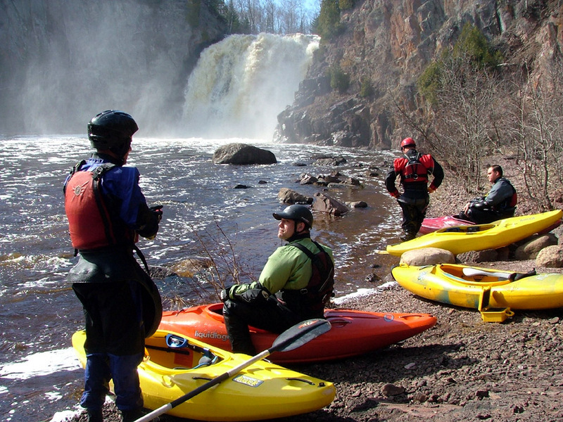
You've arrived at Illgen! If you carry out to Highway 1 here, you'll notice a house on river left. It's my understanding that this house has been acquired by Tettegouche State Park (and hopefully it will be removed!). However, it would be best to be on good behavior and ask permission before portaging or accessing the river here. The portage trail around Illgen is on river left, atop the cliffs that overlook Illgen's plunge pool. It's also probably possible to portage Illgen on the right, but it would be brushy and not as desirable. Many parties take out here after a short run, so do be on your best behavior when in the vicinity of this access point.
Illegen Falls:
Illgen Falls is a beautiful, mesmerizing sight. The Baptism pours its soul over a bedrick outcrop dropping thirty feet in the process. A huge plunge pool and boil fill a kettle-like amphitheater at the base of the falls. The usual route at Illgen is around it, walking with boat on back along a steep narrow trail that reaches some 'seal launch' rocks about 200 feet downstream of Illgen. Illgen has been swum by a boater who abandoned ship at the small ledge that's perhaps fifty feet above Illgen. It must have been a terrigying few moments to see your boat go over the brink and then to realize that you are about to follow. Fortunately, the paddler went deep into the plunge pool and escaped unscathed, to be the star of the show at the bar that night. This incident scares me, though, because it is one of a handful of incidents on the North Shore in which a boater was swept over something he had no intention of running. When thta happens, death is a real possibility. Please, please approach these rivers with respect and skill!
Illgen has been run on several occasions, usually when the Baptism is at a flow that would make the Eckbeck-Illgen run a bit scrapey. At high flows the hydraulic at the base of the falls is extremely powerful and surges towards the surrounding cliff walls very strongly. At very low flows the plunge pool isn't as well aerated and paddlers risk sharp impact if they 'pancake' on landing.
Fred Young (Fearless Fred) was the first over the falls in the late 70s. After a summer of romantic heartbreak, Fred was ready to go it along in his C-1. The atmosphere was electric as he paddled towards the edge and over. The hull of his boat bounced lightly off of a water-covered projection just right of river center and he hit the pool at an angle 'porpoising' up smartly.
Then it was my turn. I distinctly remember the gut wrenching sensation of seeing tree tops beyond the lip as I neared the brink, then going over smoothly with the water. The landing was unexpected bliss, just softly piercing down and down into the depths of aerated water at the bottom - unbelievably soft. After total submersion I popped up to be pressed gently against the left cliffs, where I rolled and then paddled on. What a feeling!!
We measured the falls wiht a throw rope and found it to be thirty feet seven inches high. Fred returned another day with some Idaho paddlers for more successful runs. Ross Peterson, Marcus Witt, Chris Nybo, John Alt and John McLaughlin are among the growing cadre of North Shore experts who've taken the plunge.
I returned during the low water spring of 1988 with the Anokas (Mike Cotten, Dean Johnson, Mark Gibson, Al Sabean, Paul Douglas and Steve Henderson). This time all runs though different went well until the last. Paul charged over the lip but the bow of his boat hit the same projecting rock that Fred had touched years before. Instead of just boucning off his boat twisted so as to land almost flat. The impact severely compressed his back and he floated up to us still in his boat writhing in pain. We extracted him from the boat, and while no permanent injury was done, our exuberance was dampened.
Illgen can be run safely - but at low flow you must either avoid the rock projection or gather enough speed to clear it after cresting the lip. At higher flows you must decide how you will deal with the hydraulic. To date all runs have been succesful with the only injury being Paul Douglas's temporary back injury. No doubt about it, Illgen is a mighty drop.
Illgen Falls to the Lake:
This section, while not sustaining quite the high level of boating found on the Eckbeck-Illgen run, contains two of the most difficult rapids on the river, two spectatcular falls, enchanting scenery and a wonderful feeling of completion on reaching Lake Superior. Immediately below Illgen the river stumbles over and around a series of small ledges and boulders that come in rapid fire succession, fun class III water that occasionally holds a snag. Then, in the next half mile, several minor ledges provide an opportunity for some play. The last of these ledges has a hand painted sign next to it naming the four foot drop 'Patty Cake Falls.'
The river changes to class II boulderbed and flows between low banks for about a third or half a mile below Patty Cake Falls. It's time to get out immediately when you see a footbridge over the river. This bridge is for the Superior Hiking trail and provides an access to the Tettegouche State Park campground if you'd like to hike in (or out!) at High Falls. Take out on river left where the shore turns into a rock shelf, right near the bridge supports. Heed this warning for just around the corner is High Falls, about a sixty foot drop.
A nice trail on the left brings you a view of High Falls roaring over a slab of bedrock. It appears to hit the bedrock sheet again near the pool and has never been run. On one occasion a hiker was swept over the falls. The hiker survived but suffered some temporary partial paralysis. Continuing along the trail on river left you will reach a branch in the trail where you can descend to the base of the falls. Make sure to feel the 'hurricane wind' coming off the base of the falls and check out the foam pile on river right. A spectacular place.
When you head downstream, you'll see a couple large boulders, then a medium ledge. Time to wake up since 'Two Step' is just ahead. Two Step resides about a third of a mile below High Falls and should definitely be scouted from the left. Some will choose to portage and above 3 feet on the gauge, the hole at the base of the second step will scare away most. The first drop is a joy - the paddler shoots over a rooster tail ramp to 'boof' into a deep and foamy pool eight feet below. There's an eddy below the first step to recover in. Pete Cary needed it when he ran too far right on a pioneering run and bottomed out, cracking some ribs. A small ledge between the Steps has distracted a boater or two as they approached the second step of Two Step, fifty feet from the first step. The second step provides nine or ten feet of exhileration as the rier sweeps over an intricate crescent-shaped ledge. Going far right over the 'shoulder' of water banking off the right wall is the most straighforward route, 'The Missouri Route,' named for some down south visitors. It'll immerse you and clean out your nostrils! Another approach is to ferry right to left and aim to get to the left side of the crescent, a delicate move. The center can hold boat and paddler - it demonstrated that you can survive running the lower drop upside down in a C-1 but it's not recommended.
You're past the major drop of the lower run now, but approaching a dangerous spot: The Cascades. At The Cascades the river slams through a narrow cut (6-8 feet) into a wahing machine pothole, spews out twenty feet or more in a hundred feet. It has never looked like a run to me, but it's a beautiful spot. There's a rather rugged portage on the left that ends up sliding down a muddy ravine to put in at the base of The Cascades. The danger here is in the approach to The Cascadess, for the river slowly increases in difficulty from easy class II to become harder. The whitewater won't overwhelm you, but you may not notice that the left shore has turned into a slick slope of moss covered rock slipping smoothly into the river. It has a couple of narrow one boat eddies early on, but provides no shelter when the rapids take off, a funnel enticing you to go just a little too far. I encourage first-time adventurers to get out a little early and check it out from shore.
Once on shore, be careful; the rocks are slippery, as Jim Pedginski found out. He was portaging just ahead of me when he slipped, fell on one knee braking his kneecap. The impact jolted his boat out of his grasp and it slid into the river and over The Cascades. We recovered the boat from the boulders below.
Below The Cascades is a fun boulder drop, then class II boulderbed for a half-mile which includes an island. A hundred yards after the island, the river twists sharp right. This is the lead-in to 'Hole-in-the-Rock,' a IV. Nice waves, as the river drops evenly through a narrows then turns exciting at the end as the river plunges down a six foot drop amongst a tangle of boulders. Paddle hard! One of the boulders on the left has a half foot diameter hole drilled in it by the current. Sometimes this hole is under water. This 'drilled' rock gave the rapid its name.
You are now about a half mile from the Lake. The river eases until just above the Highway 61 bridge when a staccato series of ledges sends you scrambling. One hole near the river gauge for unsuspecting newcomers to hit the 'Gauge Hole' is one of the chief amusements for North Shore regulars. A couple more drops and bends and you reach the gravel bar at the river's mouth - a beautiful and serene place to end a river trip.
I usually enjoy a short paddle at the mouth of the Baptism after each river run, admiring Shovel Point to the east and the view of Palisade Head to the west. Sometimes big breakers are coming in - once we spent forty hair raising minutes recovering swimmers and boats unwittingly trashed in big surf. Fortunately, the lower Baptism is protected by Tettegouche State Park. Tettegouche State Park offers camping and many miles of wonderful hiking trails, some of which give boaters a chance to scout parts of the river from High Falls down. The Tettegouche information station and rest area off of HIghway 61 is a great place to load up on state park maps (free!), maps for the Superior Hiking Trail (free!), books about the North Shore and other interesting literature.
So there you have it, the three secitons of the Baptism: falls, playspots, class II, II, and IV plus a class V, cliffs, cascades, an ending on the biggest lake in the world. All this leads me to a conclusion: The Baptism would be a classic in any kayaking guidebook.
Rapids in this Run (5)

Waterfalls (3)
Hazards & Portages (2)
Caution: The following locations may require scouting or portaging. Always check current conditions.
Difficulty
Class II-V
Length
3.8 mi
Gradient
110 ft/mi
max 180
Rapids
5
2 Portages
Access Points
Difficulty Classes
I Easy
II Novice
III Intermediate
IV Advanced
V Expert/Extreme
VI Unrunnable
Current Conditions
5-Day Forecast
Whitewater data from
American Whitewater
American Whitewater