B) Waterford/Rochester/Burlington (PnP)
Gauge Conditions
Runnable: ? – ? CFS
Approximate reading: This gauge is 0.3 miles away on Fox (Illinois R. trib.). Use as a general reference only.
Data from American Whitewater & USGS
Run Map
Run Time Estimate
Select put-in and take-out to estimate time.
Plan This Trip
See wind-adjusted speed maps, forecast planning, and detailed time estimates.
Sign in to generate an AI timing estimate for this run.
Whitewater timing varies with scouting, portages, and group pace. Use as a planning baseline.
Description
Quick Facts
Location: Case Eagle Park, Rochester
Put-in/Take-out/Parking: 42.7357, -88.2248
Shuttle Length: 100 yards (walking, from parking lot to below dam at river's edge)
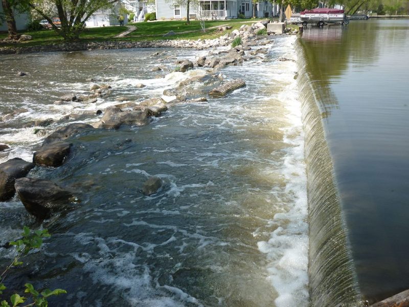
Character: A single (or multiple) wave in the outflow of a dam (and, alternatively, an area of shoals).
\- - - - - - - - - - - - - - - - - - - - - - - - - - - - - - - - - - - - - - - - - - - - - - - - - - - - - - - - - - - - - - - - -
Drainage Area: 767 square miles
Nearest whitewater runs (alternatives/'daily doubles'): White (Lake Geneva), Root (Racine), Milwaukee (in Milwaukee)
Whitewater rivers with most similar drainage area: Baraboo (609 sq.mi.), S.Fk.Flambeau (609 sq.mi.), Eau Claire (Little Falls to Big Falls, 760 sq.mi.), Milwaukee (in Milwaukee, 696 sq.mi.)
====================================================================
As with a great many 'low-head' dams, to prevent scouring of the riverbed, there are large rocks throughout the outflow of the dam. If you flip, it is extremely likely you will suffer a hard hit on one or more of them. Thus, it is hard to recommend playing these features unless you are a highly experienced playboater, justifiably confident in your ability to surf the features without flipping. (We also might recommend a full-face helmet (chin-guard/face-guard), elbow/forearm pads, and maybe even shoulder pads for anyone opting to play here!)
Notes regarding gauge/flows/playability for these features:
Unfortunately, it is very difficult to know what conditions will be present without actually going for a first-hand look. The 'virtual gauge' on this page is not reliable nor sufficient to ensure playability at any of the features listed here -- it's merely an indicator (and it's the best we can do online). It uses a USGS gauge many miles downstream, after a few substantial tributaries, and with dams regulating or altering flows here and elsewhere upstream of the gauge.
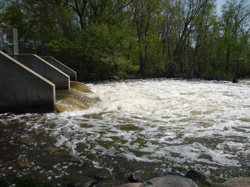
During winter months and during times of high flows, the Rochester Case-Eagle Dam may have more than just two gates open. (When three or all four gates are open, it 'floods' the pool and wipes out the wave.)
When the dam is releasing with two gates open, the following should hold fairly true:
At lower flows (perhaps 100-200 cfs on virtual gauge), there may be tame front surfs, side-surfs, and possibly flat spins.
At moderate flows (likely 200-425 cfs on virtual gauge), the waves tend to be a bit chaotic and less inviting. (More likely to flip you, thus more likely to suffer hard hits on shallow rocks! Thus, you'll notice color-coding is green/'boatable' at lower flows and at higher flows, but shows blue/'too high' in this flow range!)
At somewhat higher flows (likely 425-560 cfs on virtual gauge), the waves smooth-out again and allow exciting fast front-surfs.
At some higher flows (uncertain of values), it is possible there may be some surfable waves as the outflow heads into the pool. However, at higher flows, more than two gates may be open, and the pool area may be awash, with no defined waves or features. And ... if this is running that high, there are likely other places (in the Greater Milwaukee area) with good flows, with more playable features, and which generally lack the major risk-factors that this location has.
====================================================================
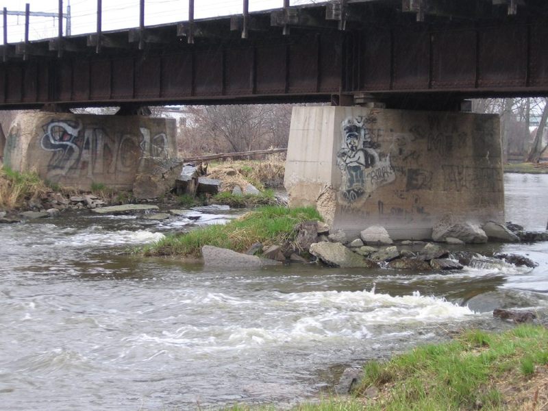
If you make the trip to Case Eagle Park and find the feature(s) looking not inviting, you may wish to drive down to Calumet Street in Burlington to check out the 'Calumet Channels'. The action there is nearly always very lame/tame, but can allow some moving water practice. At some flows it is possible that a few small surfable waves can exist, and (for those with slicey boats, interested in stalls and squirts) there are areas with good depth and interesting currents in the rightmost channel around the bridge piers.
====================================================================
Failing to find whitewater interest at either location, if you bring a bike, you can *somewhat* salvage your outing with a ride on the multi-use 'Seven Waters Bike Trail'. Much of this ~17-mile trail parallels Hwy.36, thus suffers traffic noise, lack of solitude, and greatly diminished scenery. However, a 2-mile section (partly paved, partly lime-chipped) departs Hwy.36 to meander through wooded tracts, and features a scenic bridge over the Fox River. About 0.25 mile segment (connecting Case Eagle Park to Saller Woods) is on CTH.W which has surprisingly heavy traffic (it becomes Front Street in Rochester, and North Browns Lake Drive as it heads toward Burlington). Be mindful of traffic (make certain not to wander out of the bike lane!) until you return to the seclusion of the woods.
Rapids in this Run (1)
Playspots (2)

Hazards & Portages (3)
Caution: The following locations may require scouting or portaging. Always check current conditions.
Difficulty
Class I(II)
Length
0.5 mi
Rapids
1
3 Hazards
Access Points
Shuttle Info
As far as whitewater interest goes, this is best done (such as it is) as individual 'park-and-play' areas, so shuttle is on foot. Therefore, we have set the info below to show distance, time, and directions from your home area. We have also set **put-in/take-out** coordinates for this section to be **within the Case-Eagle Park**, since this is the most likely (of the three areas listed) to hold any actual whitewater interest. Use maps and smart-phone apps to work out directions for other locations, if/when desired.
You can use the text entry box below to enter your home or other starting address (not just zip, but an address in virtualy any format, including lat/lng) to get more specific drive time, distance, and directions to the Case-Eagle Park.
Difficulty Classes
I Easy
II Novice
III Intermediate
IV Advanced
V Expert/Extreme
VI Unrunnable
Current Conditions
5-Day Forecast
Whitewater data from
American Whitewater
American Whitewater