Calumet Street Channels/Burlington Shoals
Save this feature with the run it belongs to.
Gauge Conditions
Approximate - nearest available gauge. Use as general reference only.
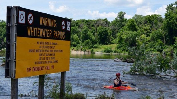
Photo
Description
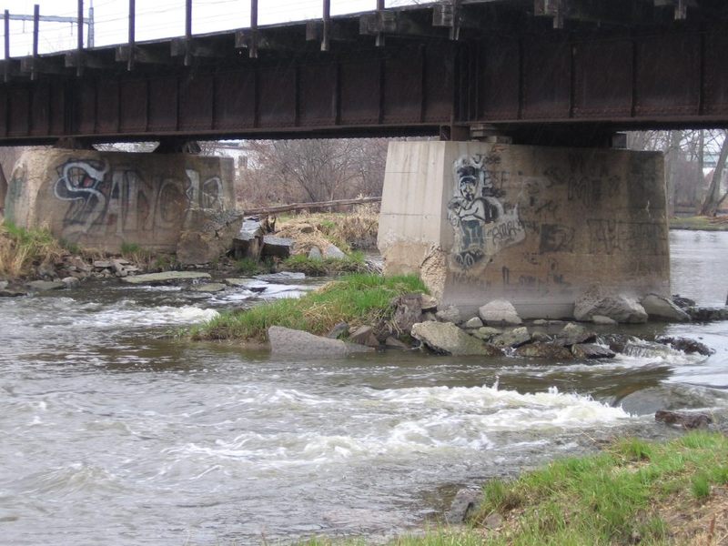
Just beyond downtown Burlington (9.25 miles downstream from the dam in Waterford, 7 miles downstream from the Rochester Case Eagle Park dam), the Fox River spreads wide (approximately 110 yards/330 feet) as it threads between islands and passes under a (defunct) railroad bridge.
As previously detailed, this area is accessible on river-right (west bank) from the end of Calumet Street, where there is parking for a fenced-in dog-walk area. (Hmmm, does that make this a 'bark-and-play' spot?) Alternately, on river-left (east bank) this is accessible from Bushnell County Park.
As of summer, 2016, the defunct railroad bridge crossing the river here has been fenced off at both ends (likely due to a combination of vandalism, time, and neglect, resulting in concerns regarding liabilities). This makes it extremely difficult to scout this area before just boating it. Anyone who bothers to boat this area (I.E., to explore it fully, not just downriver passing through), will likely find it necessary to beach on various islands and shores to carry up and then (at the end or your attempted play) to return to whichever shore you began, to carry back to your vehicle.
The river is split into a number of channels -- three more-or-less 'main' divisions made by islands before the bridge, with each of those channels then split in two or three by bridge piers. A total of 7 bridge piers make 8 channels (though at least one of those is exclusively a high-water/flood channel which will be dry land most of the time).
Each channel contains a different amount of the flow of the river (obviously) and has differing rock/rubble clutter, creating differing potentials for play. Some channels are relatively tame (worthless) at virtually all flows. At low flows (under 500 cfs on New Munster gauge, or under 250-275 cfs on our virtual gauge) there is not likely enough water in any channel to provide any play (or much depth -- you will scrape across the rock and gravel bottom through most of these channels). The whole area washes out at high flows (above 1000 cfs or so on the New Munster gauge ... around and above 550 cfs on our virtual gauge), making virtually no reason for being there. Levels between (roughly) 500 and 1000 cfs may provide some minor play, but don't expect too much out of this area.
The right-most channel (actually, pair or channels, split by a bridge pier) contains the greatest flow (perhaps nearly 30-40% of the flow of the river). The eddy immediately behind the bridge pier has pretty fair depth (for possible vertical moves -- bow stalls, stern squirts). As the river quickly shallows downstream, a couple minor riffles (possibly a surfable wave) may exist before the end of the islands where all channels reconnect.
The left-most channel (again, actually, pair of channels, split by a bridge pier) probably is the second largest (perhaps 25-30% of the flow of the river). Rocky constriction (under the railroad bridge) and shallow bottom combine to create strong current through here. A potentially surfable wave may form at flows in the higher end of our 'recommended flows', but at low-to-moderate levels the shallow rocky shoals not far downstream will virtually preclude any repeat play here.
The remaining 'middle' channels are all much smaller (10-15% or less of river's flow). These are likely to be the better play available (such as it is) at this location, as they (surprisingly) have a bit more of a 'pool' immediately below the bridge (allowing for easy repeat play) and generally lack the shallow rocky shoals found in the larger right and left channels. At the lower range (of cited 'runnable' flows) they may provide some easy surfing opportunities (front-surfs, side-surfs, and flat spins).
It may be noted that (upon a few visits here, years back) there was some evidence of modification ('rock stacking') in some of the channels. These manipulations will be nearly futile here, as any attempts to pool-up or constrict flow in any channel (to modify and create a playable feature) mostly just results in the other channels getting some additional flow. Even more relevantly, any rock capable of being moved by human power will, with virtual certainty, be moved by the river (especially every spring, at 'ice-out', as massive sheets of ice bulldoze their way downriver). As well, any rock-dam creates 'scour' immediately behind itself (especially here, since there is mostly soft, erodable riverbottom). In what is likely to be a very short timeframe, this erosion will cause the rock-dam to collapse into the scour pit. (Your rock-dam will create it's own demise unless you also ‘armor’ the river bottom downstream of it with substantial rocks, which you are unlikely to do!)
Location
Other Rapids on This Run (6)

Current Conditions
5-Day Forecast
American Whitewater