Co.Hwy.8 to Hwy.61 (6.66 miles)
No sufficiently local live gauge linked. 1 automated match was excluded because the closest is 30.4 miles away. Difficulty and route details are not current water conditions.
Run Map
Run Time Estimate
Select put-in and take-out to estimate time.
Plan This Trip
See wind-adjusted speed maps, forecast planning, and detailed time estimates.
Sign in to generate an AI timing estimate for this run.
Whitewater timing varies with scouting, portages, and group pace. Use as a planning baseline.
Description
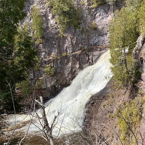
OK, I've been asked a few times "What's up with the Caribou?" "Everything else of any decent size up the North Shore is listed on AW . . . Why isn't this?" And, frankly, I have to say I don't know. A USGS sampling site near Hwy.61 lists drainage of 23 square miles . . . bigger than the Stewart, French, and Amity (all of which are boated). Yeah, there's a BIG unrunnable (I think . . . or?) falls, but that's nothing new for North Shore runs. Looks like it's got access for a good run. Aerial views online hint there may be a problem with wood . . . is that it? Too many snags? Or . . . maybe the other listed smaller watersheds all channel up nicely through their gradient and this one has too many broad areas of rocky shoals making for scraping or portages?
Anyone with the lowdown is encouraged to help out your fellow boaters with some info here. Save someone the bother of trying for it (if it's not worth the doing) or . . . if it has merit, let us know that too!
Rapids in this Run (3)
Waterfalls (1)
Hazards & Portages (1)
Caution: The following locations may require scouting or portaging. Always check current conditions.
Difficulty
Class II-IV(V+)
Length
6.2 mi
Gradient
105 ft/mi
Rapids
3
1 Hazard
Access Points
Shuttle Info
This shuttle is somewhere near a half-hour (each way). We highly recommend meeting at take-out, gearing up, swapping boats and boaters to as few vehicles as possible (to leave 'drop vehicles' there), then driving to put-in to run river. This gets you on water without the delay which would result from meeting at put-in, having to run shuttle down and back up (while some boaters wait somewhere near a full hour) before putting on river!
Difficulty Classes
I Easy
II Novice
III Intermediate
IV Advanced
V Expert/Extreme
VI Unrunnable
Current Conditions
5-Day Forecast
Whitewater data from
American Whitewater
American Whitewater