D) Sec.3: Langlade (Hwy 64) to Crab N Jack's Landing (3.9 or 10.3 miles)
Gauge Conditions
Runnable: 200.0 – 1,250.0 CFS
~8"-15"; intermediate level.
Data from American Whitewater & USGS
Run Map
Run Time Estimate
Select put-in and take-out to estimate time.
Plan This Trip
See wind-adjusted speed maps, forecast planning, and detailed time estimates.
Sign in to generate an AI timing estimate for this run.
Whitewater timing varies with scouting, portages, and group pace. Use as a planning baseline.
Description
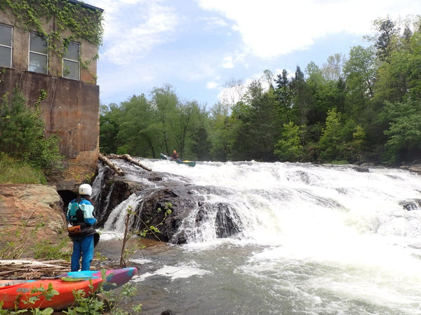
Most of the river bank on this section (until the end of the run) is under state ownership, giving the feeling of paddling in a wilderness setting.
The full run beginning at Langlade (a 10.3 mile stretch with several Class II+/III rapids and some long flatwater stretches) is historically referred to as _Section III_. However paddlers often prefer an abbreviated section (called _'Short III'_) by putting in at the DNR landing off of County Highway M. This put-in is below Twenty-Day Rapid and above Boy Scout, yielding a 3.9 mile trip which catches the three main drops. Either option finishes immediately around the bend after Gilmore's Mistake.
Be aware that immediately downstream of this take-out lies the county line! Proceeding downstream is trespassing into the Menominee Nation, which can be done only after paying a 'trespass fee' to get a wrist-band to boat the next stretches of the Wolf.
This access point is privately owned by Crab n Jack's. Don't drive your vehicle down to the take-out point! Park vehicles in the 'boater's parking' area they have graciously provided. Carry your boat from the landing to your vehicle. If you have a dog with you, don't let it run around unleashed. And spend a few dollars at the bar and restaurant to thank the owners for providing this important access!
Difficulty
Class II(III)
Length
10.1 mi
Gradient
19 ft/mi
max 40
Rapids
8
Access Points
Shuttle Info
The 'automatically created' directions (bottom of this page) show directions for 'long 3' (full section). However, most whitewater boaters interested in the best rapids and least flatwater do 'short 3'. The first maps below provide detail for the shuttle for that shortened trip.
Shuttle Information (for the short run>: Length (each way): 3.1 miles, Estimated Time (each Way): 6 minutes
[View Larger Map](http://maps.google.com/maps?f=d&hl=en&geocode=5648198682415086935,45.119591,-88.663513%3B12311269771261458038,45.124640,-88.712540&time=&date=&ttype=&saddr=45.1195908+-88.6635132&daddr=45.1289,+-88.7070&sll=45.125322,-88.682756&sspn=0.027675,0.083685&ie=UTF8&ll=45.125079,-88.682928&spn=0.00636,0.04512&t=h&om=1&source=embed)
Clicking on "View Larger Map" will open a new browser window. When done, close it to return here. From this map you will be able to zoom in or out to determine logistics. You can click a link on that page to get driving directions (including drive-time and distance) from your location.
* * *
Difficulty Classes
I Easy
II Novice
III Intermediate
IV Advanced
V Expert/Extreme
VI Unrunnable
Current Conditions
5-Day Forecast
Whitewater data from
American Whitewater
American Whitewater