Elgin: Eagle Heights Park to Fox River (4 miles) *** Access Issues ***
Gauge Conditions
Data from American Whitewater & USGS
Run Map
Run Time Estimate
Select put-in and take-out to estimate time.
Plan This Trip
See wind-adjusted speed maps, forecast planning, and detailed time estimates.
Sign in to generate an AI timing estimate for this run.
Whitewater timing varies with scouting, portages, and group pace. Use as a planning baseline.
Description
Quick Facts:
Location: Elgin, IL.
Shuttle Length: 2.4 miles/7 minutes *Click here for shuttle route*
Character: In town run, through wooded parks, past homes, and finishing on a college campus.
Drainage area: approximately 38.9 square miles (at gauge at Big Timber Road).
Put-in elevation is approximately 795'.
Take-out elevation is approximately 710'.
Thus total elevation change is approximately 85'.
Information (lat, lng, elev, total drop, run length, shuttle length) adjusted and/or verified from best manual extrapolation of online data (via maps.google.com, distance measuring tool, and other resources). 2009.03.10
Richard DeGroat (Sugar Grove) and Andy Smith (Hinckley) provide (2009-03-14):
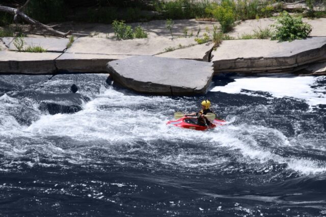
*Not a bad little creek at all for the beginner boater at a low level (around 100 cfs) and the intermediate paddler at a higher level (200 cfs plus). The day we ran it it was rather low but still enjoyable (112 cfs). A couple of strainers that hopefully at higher levels would be overcome with water (always scout if inexperienced with river reading). From the old dam at the park down to Judson College is where the creek really comes alive. Can't wait to paddle it at around 275 cfs. which I think will be an ideal level.*
We have no specific info on viable put-in location, shuttle information, drops or features. We encourage additional input from any knowledgeable paddler.
There are reports that Judson College (and its security personnel) are likely to take issue with boaters being on this stream. DO NOT GO ASHORE WITHIN COLLEGE PROPERTY!
Rapids in this Run (2)
Playspots (1)
Difficulty
Class I-II
Length
3.9 mi
Gradient
21 ft/mi
Rapids
2
Access Points
Shuttle Info
We are uncertain of exact location of usual or best access for put-in. Listed is just a guess, based upon second- or third-hand info suggesting the run is 'about 4 miles long' and 'finishes in Judson College or at Fox River'. As a result, the following shuttle information may not be accurate either. Anyone with more specific information about access and parking for put-in is encouraged to provide that info for your fellow paddlers.
Difficulty Classes
I Easy
II Novice
III Intermediate
IV Advanced
V Expert/Extreme
VI Unrunnable
Current Conditions
5-Day Forecast
Whitewater data from
American Whitewater
American Whitewater