Fonferek Falls to Hwy.V/Tordeur Ct.(4.3 miles)
Gauge Conditions
Runnable: 285.0 – 875.0 CFS
Likely less than 150 cfs; Almost certainly too low for reasonable whitewater boating.
Data from American Whitewater & USGS
Run Map
Run Time Estimate
Select put-in and take-out to estimate time.
Plan This Trip
See wind-adjusted speed maps, forecast planning, and detailed time estimates.
Sign in to generate an AI timing estimate for this run.
Whitewater timing varies with scouting, portages, and group pace. Use as a planning baseline.
Description
Quick Facts:
Location: Approximately 9 miles SE from downtown Green Bay, WI.
Shuttle Length: 3.3 miles.
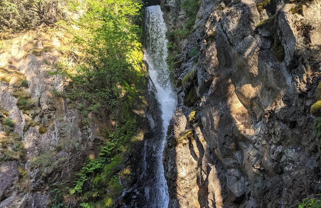
Character: Small creek with bedrock river-bed. A sheer vertical waterfall drops into a grotto. The creek caroms down sloping bedrock for the next mile or so.
Drainage area at put-in: approximately 14.8 square miles.
Put-in is approximately 767' elevation.
Take-out is approximately 597' elevation.
Thus total elevation change is approximately 170'.
Nearby ('companion') runs (with drainages, for comparison): Baird Creek (15.7 sq.mi.), School Creek (15 sq.mi.), Devil's River (36 sq.mi.), Neshota/West Twin (43 sq.mi.).
General Overview
This little creek boasts an impressive (for EastCentral Wisconsin), scenic, ~20' waterfall, followed by a scenic dells section. That said, you'll be so busy with an assortment of sloping bedrock slides, and scattered quarry-like rubble which litter the rapids, along with the fact that there will be precious few eddies in this first stretch, so it's doubtful you'll have much time to admire the scenery.
This is NOT recommended for anyone in a 'recreational kayak', and is NOT recommended for anyone without considerable whitewater skills and experience. This creek is narrow, with high banks, tight/blind curves, quite continuous action (especially in the early going), and has areas which are routinely completely blocked by deadfall. There is precious little margin for error. If you can't catch a 'one boat eddy' (or if you have no idea what that even means), then you should not even think about floating this stretch of river! At anything more than minimal flows, if you can't catch an eddy, if you can't self-rescue (if you can't roll your kayak), expect to swamp your boat, lose your paddle, and possibly lose your boat!
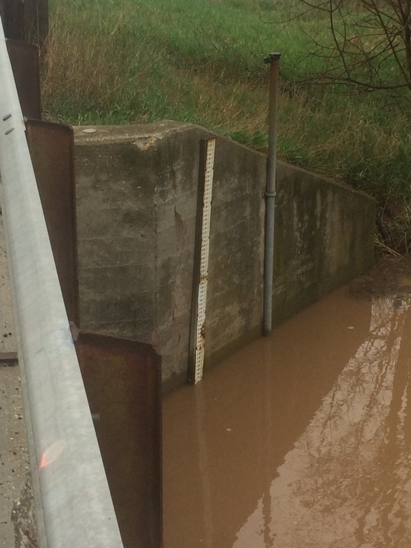
Boaters should be aware that **the pool at the base of Fonferek Falls is *very shallow*, virtually never exceeding 2.5 - 3.0' in depth! Good boof technique (with unlocked spine) is mandatory here! While we are aware of successful runs, we are also aware of a nasty piton resulting in a painful break, with a resultant grueling ordeal to get across the creek, up out of the 'canyon', and to medical attention, and many months recovery and rehab.
We therefore have to suggest in the strongest of terms that running the falls is NOT recommended**!
(Note: For this reason, gradient figures cited above *exclude* Fonferek Falls.)
Action is pretty continuous in the half-mile (give or take) below the falls. Not far downstream of the falls there is one ledge of sufficient size (a foot or two) to create a wave/hole (possible play at moderate flows, possibly sticky at some flows). It comes pretty quickly, as you head toward a wall of rock and the creek is diverted about 90 degrees to the right, at the location of a 'skylight' (significant overhanging caprock, well overhead, with a large hole in it). Downstream the creek gently bends a little further right before being diverted sharply left and into a fine II-III rips (solid III or better at moderate-to-high flows). Large slabrock litters the center and right of the channel down this swift pitch (right where the current is taking you). (This means likely major head banging if you flip, or body damage if you swim here!) This corner has often had overhanging branches, overarching trees, and occasionally other woody debris complicating the channel.
Boaters are STRONGLY advised to scout this area before putting on! There will be virtually no eddies, and no way to safely get out of your boat to get around any problem here.
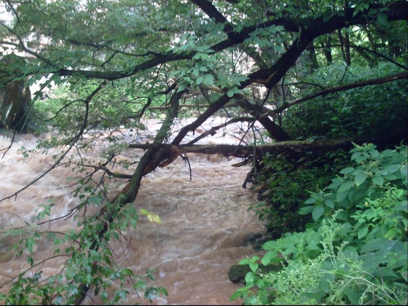
Not far beyond, the gradient eases a bit and you'll see signs (posted on trees onshore) that you are leaving the county park and entering private property. You could take out before the private property signs and carry back up to your car (or do 'laps' in the park) to avoid having to run a shuttle. The action eases up considerably for a while. There will be an area of serious deadfall and braided channel which will require significant skills and careful navigation (especially with the Bower Creek staff gauge at 9' or higher) to successfully pick a boatable route. However, there are still numerous areas of fine rapids (mostly class II, a few which may push into class III or better at some flows) to be found downstream.
Boaters who have looked at detailed maps may be inclined to shorten the trip utilizing a take-out at the end of a road which dead-ends near the creek on river right. However, it would be necessary to hike a quarter-mile or so, up a somewhat steep climb on a gravel double-track. The land is all privately owned, so permission to trespass would need to be secured. And, you would probably need to hike down to the river (after obtaining permission, as you set a shuttle vehicle here) to be able to recognize this alternative takeout from the river, since it will not otherwise be obvious from the creek. When there is adequate flow to run the creek, the float to the listed take-out will be swift. The float through the golf course is interesting and scenic, with no 'too-low' bridges to worry about until/unless boating at flows higher than 9.5-10'. Not far downstream of the golf course, the creek comes immediately adjacent to a side-road at the listed take-out for very convenient access.
Special Note: The real HUC for this reach should be 04030204. It has been 'faked' below to allow this reach to 'sort' (when listing is pulled up 'by drainage') into the 'Southwestern Lake Michigan' rivers, rather than the already bloated list of 'Northwestern Lake Michigan' rivers.
If this somehow causes problems for anyone using this listing, please send a message to the Regional StreamKeeper (which can be done via the 'Comment' box which should appear below for all registered and logged-in users).
Rapids in this Run (9)
Playspots (1)
Hazards & Portages (1)
Caution: The following locations may require scouting or portaging. Always check current conditions.
Difficulty
Class II-III(IV)
Length
4.4 mi
Gradient
40 ft/mi
max 80
Rapids
9
1 Hazard
Access Points
Shuttle Info
For shuttle directions from the alternate take-out, enter 44.443, -87.9496 into the text-entry box below.
Otherwise, as always, you can enter your home or other starting location into the text-entry box to get drive time, distance, and directions to this river (put-in).
Difficulty Classes
I Easy
II Novice
III Intermediate
IV Advanced
V Expert/Extreme
VI Unrunnable
Current Conditions
5-Day Forecast
Whitewater data from
American Whitewater
American Whitewater