Forest Road to Forest Highway 360 (4.26 miles)
Gauge Conditions
Runnable: ? – ? CFS
Approximate reading: This gauge is 8.6 miles away on White Deer Creek. Use as a general reference only.
Data from American Whitewater & USGS
Run Map
Interactive run map
Loads as you approach this section.
Run Time Estimate
Select put-in and take-out to estimate time.
Plan This Trip
See wind-adjusted speed maps, forecast planning, and detailed time estimates.
Sign in to generate an AI timing estimate for this run.
Whitewater timing varies with scouting, portages, and group pace. Use as a planning baseline.
Description
Quick Facts:
Location: approximately 7.5 miles NW from Bergland.
Shuttle Length: 4.3 miles.
Character: Small drainage, small stream.
Indicated put-in elevation is approximately 1240'.
Take-out elevation is approximately 980'.
Thus total elevation change is approximately 260'.
Information (lat, lng, elev, total drop, run length, shuttle length) adjusted and/or verified from best manual extrapolation of online data (via maps.google.com, distance measuring tool, and other resources). 2009.01.29
* * *
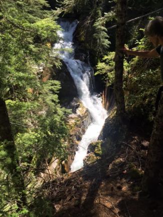
This creek is a tributary of the Big Iron (which flows through White Pine and Silver City before reaching Lake Superior). While not having sustained gradient nor a multitude of complex drops (compared with other U.P. runs), there is a named waterfall and numerous evident rapids.
Drainage area above Deer Creek Falls is only about 2 square miles, so it may take unique circumstances to make it 'go'. Thus, this reach is being listed (with this as the 'put-in') almost exclusively for the possibility of going to have a look at this remote falls.
Slightly more realistically, it may be possible to start at the first bridge, 1.39 river miles downstream from the listed 'put-in'. A couple of fairly significant tributaries contribute to the flow (still only on the order of 5-6 square miles, so we're still talking tiny). If this potential put-in works, this elevation is ~1040', leaving a run of 2.87 miles and a total drop of 60', or 21 FPM. This may mean some class I-II rapids, or could be frittered away with little more than splishy-splash swiftwater. (Class/rating listed for this reach is completely conjecture.)
Downstream of the listed take-out, the next 5.5 miles are much lower gradient.
So . . . has anyone ever looked at this falls or this section of river? Leave a comment or report!
Waterfalls (1)
Difficulty
Class I-II(IV)
Length
4.4 mi
Gradient
50 ft/mi
max 120
Rapids
0
Access Points
Difficulty Classes
I Easy
II Novice
III Intermediate
IV Advanced
V Expert/Extreme
VI Unrunnable
Current Conditions
5-Day Forecast
Whitewater data from
American Whitewater
American Whitewater