Waterfall
MI
Deer Creek Falls
Save this feature with the run it belongs to.
Gauge Conditions
Runnable: ? – ? CFS
Approximate - nearest available gauge. Use as general reference only.
Data from American Whitewater & USGS
Photo
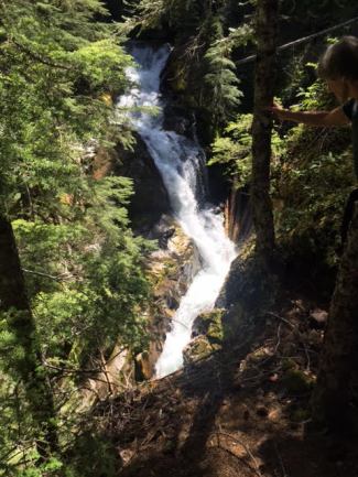
Photo courtesy of American Whitewater
Description
The river drops 30' in a very short distance (and a bit more just downstream). However, it is so far up the watershed that it is unlikely to be found runnable unless the rest of the area is pretty much in flood.
Note that (at least on the topo maps I've seen) gradient lines up here are in meters, with five-meter intervals, thus dropping two 'lines' means ten meters or about 30 feet.
Location
Interactive river map
Loads as you approach this section.
Other Rapids on This Run (2)

View Full Run
Forest Road to Forest Highway 360 (4.26 miles)
White Deer Creek
I-II(IV)
4.4 mi
Current Conditions
5-Day Forecast
Whitewater data from
American Whitewater
American Whitewater