Highway 68 to Hiwassee River
Gauge Conditions
Runnable: 3.0 – 5.5 FT
Data from American Whitewater & USGS
Run Map
Run Time Estimate
Select put-in and take-out to estimate time.
Plan This Trip
See wind-adjusted speed maps, forecast planning, and detailed time estimates.
Sign in to generate an AI timing estimate for this run.
Whitewater timing varies with scouting, portages, and group pace. Use as a planning baseline.
Description
Directions:
Putting in at Highway 68 yields a fair amount of flatwater, though there is quality scenery. There is an alternate putin that starts you right at the top of the good stuff. Coming from Tellico Plains south on 68, make a right onto Monroe County Route 628 a couple of miles after going through Coker Creek Village. After just under a mile, bear left next to a cemetary, then after half a mile, veer right at the Y. Go 2.5 miles, then make a left onto Forest Road 2138, which drops a mile to the putin. For the takeout, go back to the previous intersection, make a left, and go a few miles untill there is a turn on the left, which will lead down to the takeout almost at the Hiwassee Dries. To not miss the takeout while on the river, simply takeout below the bridge where the John Muir Trail Crosses and hike up on river right.
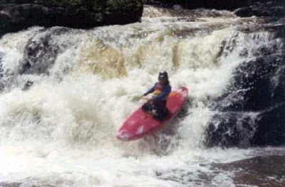
The first drop is a 4 foot boof followed by Coker Creek Falls twenty feet later. At about 18 feet, the falls is best run with a right to left motion, catching a kicker 10 feet down, and landing close to flat and sideways at the bottom. Following are some scrapy ledge features, then another cascade which can be run on right or left, depending on flow. This one is about 12 feet high. A hundred feet of bang and scrape later is an interesting drop. Called turkey tail, this rapid drops through a miniature notch, then fans out over a domed ledge dropping 10 feet and then going right or left. Left has a submerged pin rock that can be an issue at lower levels. The right is good to go. At higher levels the hole can be pretty nasty.
Aftewards is an 9 foot waterfall that lands on rocks on the right. Maybe with enough water it will go. On the left is a narrow groove that can be run, though some Mountain Laurel will hit you in the face. There is a rough, troughy small slide following, and then scout the slide. The slide starts with a 5 foot slanted drop onto a low angle slide for twenty feet into a big curl on the left thowing to the right. Go with the curl over a 15 foot bouncy slide, and then finish the rapid on the left channel, or catching the eddy on the right, and then ferrying in front of Reynold's Rock, which separates the left channel from the others. At higher water, above 3 inches, Reynold's Rock is a serious undercut, with six inches making the drop runnable only by boaters able to maintain complete control on the slide up top to avoid the pin. This is not easy. At these levels, 99% of the water goes into the undercut. At lower water, and without any push, it is quite easily avoidable with no worries, but beware at more solid levels. Below here end it by bouncing down through the many waterpark type channels. Loads of fun.
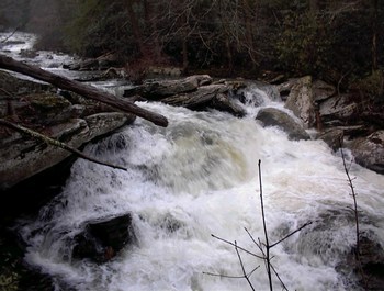
Next is a blind ledge drop best run on the left, and then it chills to busy class 3 water with a fair amount of strainers all the way to the Hiwassee Dries. This run reminds me of the Nantahala Cascades, just toned down a little bit. It runs all the time, and is beautiful. The steepest half mile clocks in at 300 ft/mile, providing some good creeking similar to the easy rapids on the Green.
Rapids in this Run (1)
Waterfalls (4)

Hazards & Portages (2)
Caution: The following locations may require scouting or portaging. Always check current conditions.
Difficulty
Class III-IV(V)
Length
5.5 mi
Gradient
80 ft/mi
max 300
Rapids
1
2 Hazards
Access Points
Difficulty Classes
I Easy
II Novice
III Intermediate
IV Advanced
V Expert/Extreme
VI Unrunnable
Current Conditions
5-Day Forecast
Whitewater data from
American Whitewater
American Whitewater