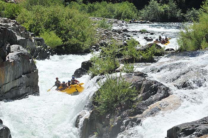
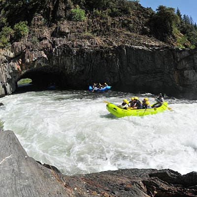
Last Chance Bridge to Middle Fork Confluence
No sufficiently local live gauge linked. 1 automated match was excluded because the closest is 50.4 miles away. Difficulty and route details are not current water conditions.
Run Map
Run Time Estimate
Select put-in and take-out to estimate time.
Plan This Trip
See wind-adjusted speed maps, forecast planning, and detailed time estimates.
Sign in to generate an AI timing estimate for this run.
Whitewater timing varies with scouting, portages, and group pace. Use as a planning baseline.
Description
This run went mostly unexplored by boaters until the mid-90s. Kayaker Brandon Nelson, one of the first to boat this section, gives this account in Holbek's Third Edition book:
_'The seven miles of road to the trailhead was snow-covered and-impassable in early April, so we elected to hike the distance and spent all day muling our gear through wet snow and mud, arriving at the crystal-clear snowmelt river at dark._
_The upper section had a lot of boat-scoutable, technical drops, and some huge class V. We ran some of the biggest drops I've seen and still walked seven times. At one point we came to a river-wide 22-footer with a near impossible-looking portage. I was concerned about our options when Barry pointed to a line and went to lead the monster...a few rapids later we came to Devil's Gate, a precarious looking affair emphasized by 100-foot vertical walls on both sides._
_The top, a 12-foot ledge into a terminal hole, is walkable on the right._
_The run was to seal-drop off a shelf onto a shallow 40-foot ramp, go off the center of a 10-foot ledge while staying away from the half-pipe on the left wall. I missed the center line, slamming into the half-pipe arcing off the wall, lost my paddle and hand-rolled; Barry rolled too but kept his paddle. It took us 6-7 hours to get to Mosquito Bridge._
_To get to the put-in, take Foresthill Road from Auburn, continuing through Foresthill about 16 miles to Deadwood Road. Turn right and follow signs that indicate '7 miles to Devil's Thumb.' From there, hike a mile and 1,800 feet down the Western States Trail to Last Chance bridge to the put-in on river right._
_To hike into the middle of the run, which is easier and more akin to say, Giant Gap, take Mosquito Ridge Road from Foresthill towards the put-in for the Tunnel Chute run. Go 6.2 miles past the turnoff for Oxbow Reservoir and park at a turnout on the left past mile marker 16. A trail leads down the ridge to a miner's cabin on river left. This is, or is near, 'Bake Oven' site shown on maps._
_The take-out is either the Mosquito Ridge Road bridge or two miles downstream at the staging area for Middle Fork rafting trips.'_
Placer County Water Agency maintains a gage and posts flow data to its website. February 2023 update: American Whitewater is working to add this flow data to this river page.
Other Information Sources:
Tahoe National Forest
American River Ranger District (530) 367-2224
The Best Whitewater in California, Holbeck & Stanley
SIERRA WHITEWATER, MARTIN, 1974 describes the last 2 miles from Mosquito Bridge Road down to the MF confluence.
Middle Fork American River Project Relicensing
Existing Resources Overview pdf
Placer County Water Agency
Upper American River Foundation
UCDavis Hydra Center, flow study news release
Rapids in this Run (1)
Hazards & Portages (1)
Caution: The following locations may require scouting or portaging. Always check current conditions.
Difficulty
Class V
Length
13.0 mi
Gradient
130 ft/mi
Rapids
1
1 Hazard
Access Points
Shuttle Info
To see if the roads to the Last Chance trailhead are open, contact the American River Ranger District office in Foresthill, (530) 367-2224
Difficulty Classes
I Easy
II Novice
III Intermediate
IV Advanced
V Expert/Extreme
VI Unrunnable
Current Conditions
5-Day Forecast
Whitewater data from
American Whitewater
American Whitewater