Route 9 & 123 to Hillsboro Fire Sta
Gauge Conditions
Data from American Whitewater & USGS
Run Map
Description
Information from Greg and Sue Hanlon's Steep Creeks of New England, additions by Nate Warren
From Concord, NH, take I-89 North to Exit 5. Follow Rte. 9-202 to Hillsborough. Continue through Hillsborough, Lower Village to North Branch Village, where Rte. 9 crosses the North Branch. To the putin from North Branch Village follow Rte. 9 ~5 miles to a small pull-off just after a set of powerlines across Rte. 9, as you are driving up a hill. Park by a gated, overgrown farm road on the left. Carry past the gate, down the farm road, and through the overgrown path. Veer left at the first fork in the path, and look close for the path on the right after another 100 yards.
To takeout: follow Rte. 9 back toward North Branch Village (in Antrim). Take out at the junction of Rte. 31 (where 31 breaks off of 9 and heads south) and Rte. 9, below The Cleaver.
Click here for a GoogleMap of the run, including access points (and scouting points)
Warning: this run may contain thick ice in the early Spring; it tends to break up later than many other, steeper runs.
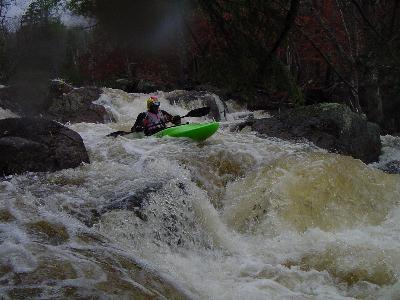
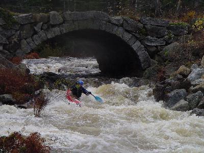
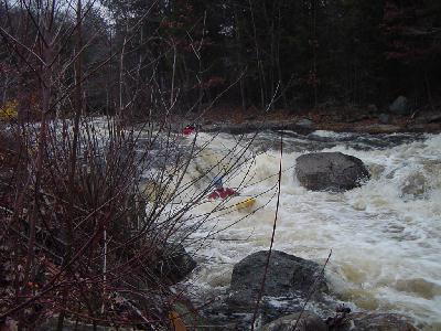
The NB Took is a class IV (2@V) creek in southern NH. It has a large, swampy drainage, which means it holds water far better than most other creeks in NH. The upper section has long zig-zagging class four rapids with big pools at the bottom. The largest rapid, Lost Lens, is class V- at good levels. Soon after Lost Lens is "Stone Bridge," a class III where the river passes under an old stone bridge, then under Route 9. Below here is a mile or so of class II-III, which is really fun if the level is not low, followed by flatwater and then Mill Race.
Mill Race is the highlight of the North Branch. The left is a 100+ yard class V rapid that ends with a difficult crux move. This one collects lost of wood. The right side is a steep 20' slide with a scrapey entrance. The slide is class V-.
Below Mill Race the river drops under Loveren Mill Road (a good place to scout, while you are dry, or for park & huck...), then into over a mile of flatwater, including a marshy swamp. If you are running the NB at lower levels, the swamp can become difficult to navigate. Some people drive shuttle around it, taking off at Loveren Mill Rd. and putting back on at Liberty Farm Road.
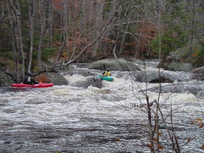
Liberty Farm rapid is the first rapid after the flatwater. It is a long class IV with many lines. After a mile or so of class II-III, the river returns to the road for the last rapid, "Cleaver." From the top the water exploding up in the center-left of the river is the spot to avoid. There is a far-left line, but generally boaters try to stay right of the Cleaver and far enough off the right side to avoid the submerged ledge at the bottom. Takeout below Cleaver, climb up the embankment & careful crossing the road!
Rapids in this Run (4)
Waterfalls (1)
Difficulty
Class V
Length
8.0 mi
Gradient
55 ft/mi
Rapids
4
Access Points
Difficulty Classes
I Easy
II Novice
III Intermediate
IV Advanced
V Expert/Extreme
VI Unrunnable
Current Conditions
5-Day Forecast
Whitewater data from
American Whitewater
American Whitewater