Sperryville to Rock Mills (Rt. 626)
Gauge Conditions
Runnable: 6.0 – 12.0 FT
Data from American Whitewater & USGS
Run Map
Run Time Estimate
Select put-in and take-out to estimate time.
Plan This Trip
See wind-adjusted speed maps, forecast planning, and detailed time estimates.
Sign in to generate an AI timing estimate for this run.
Whitewater timing varies with scouting, portages, and group pace. Use as a planning baseline.
Description
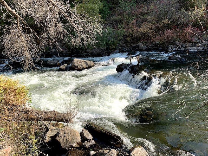
Class II whitewater with one Class III section, 'Boulder Ledge Rapids'. The classic putin is below Sperryville about a mile down from where the two forks of the Thornton meet.
Portage around the cattle fences at the beginning. It's about a mile down to the Class III rapid. The rest of the run is Class II, with the usual creeky hazards. There is a alternate takeout halfway through the run.
The North Fork of the Thornton can be run in high water conditions. The South Fork also apparently has good stuff, but you end up taking a backyard tour of Sperryville.
The Rock Mills takeout can also be used for short whitewater sections of the Covington and Rush. These are smaller streams that require more water.
See Also:
_Classic Virginia Rivers,_ Ed Grove (1992 ed), p. 85.
_Virginia Whitewater_, Roger Corbett (2000 ed.), p. 185.
_Exploring Virginia's Waterways_, Ed Gertler (2022 ed.), p. 146.
Playspots (1)
Hazards & Portages (1)
Caution: The following locations may require scouting or portaging. Always check current conditions.
Difficulty
Class II-III
Length
6.5 mi
Gradient
24 ft/mi
Rapids
0
1 Hazard
Access Points
Difficulty Classes
I Easy
II Novice
III Intermediate
IV Advanced
V Expert/Extreme
VI Unrunnable
Current Conditions
5-Day Forecast
Whitewater data from
American Whitewater
American Whitewater