Yellow Pine airport to Johnson Creek gauge
Gauge Conditions
Runnable: 300.0 – 1,500.0 CFS
Data from American Whitewater & USGS
Run Map
Run Time Estimate
Select put-in and take-out to estimate time.
Plan This Trip
See wind-adjusted speed maps, forecast planning, and detailed time estimates.
Sign in to generate an AI timing estimate for this run.
Whitewater timing varies with scouting, portages, and group pace. Use as a planning baseline.
Description
This run is continuous class II with two or three class III- boulder gardens. The road runs along the river allowing alternate access, scouting opportunities, and easy portage of the class IIIs.
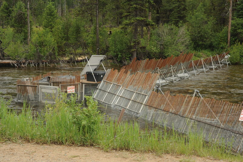
The upper put-in is one half mile above the airport bridge. Using this access point, you will need to portage the fish weir on the right. To avoid the portage, put in under the airport bridge. The run includes some fun playspots as well as class III- rapids that can be easily portaged. If you camp at Golden Gate or Yellow Pine Campground you can take out at your camp. The boat ramp at the gage is the lower take-out for this run.
Those who want to add a bit more challenge (class IV/V) at the start or end of the run can put-in higher at Ice Hole Campground, to run Dead Horse Rapid, or continue on downstream to the more challenging whitewater just around the corner from the take-out at the gage station (and just continue on down the East Fork South Fork Salmon). Those who want to stick to class II/III need to be mindful to put in a mile below Ice Hole Campground and take out before passing the gage.
Logistics:
Johnson Creek Road (FR 413) provides easy access to this run. It can be accessed from the upstream end off Warm Lake Road (FR 579) or from the downstream end off East Fork South Fork Road (FR 48). Mile markers for Johnson Creek Road begin at the south end of the road where it starts at mile 0 from Warm Lake Road. The community of Yellow Pine is at the end of the road at mile 25.0.
Put-in: The put-in is located 1 mile downstream of Ice Hole Campground at Johnson Creek Road mile 20.1 where FR 413C1 turns off and provides access to the river. This access puts you in downstream of Dead Horse Rapid. The bridge to the airport is located at Johnson Creek Road mile 20.7. Those using a plane shuttle sometimes use this as a put-in for a multi-day run that starts on Johnson Creek and continues on down the East Fork South Fork Salmon, South Fork Salmon, and Main Salmon. Those who want more challenge (class IV/V) can put in at Ice Hole Campground at Johnson Creek road mile 19.0).
Take-out: You can take out at the Yellow Pine Campground at mile 24.6 on Johnson Creek Road. Another alternative is to continue on to the end of Johnson Creek Road (mile 25.0) and its intersection with Yellow Pine Ave and Stibnite Road in Yellow Pine. From this intersection head west (down hill) 0.4 mile to a bridge over the East Fork South Fork Salmon. Back up one tenth of a mile and go down the steep access and look for the gage. The take-out is the boat ramp at the gage. You can also take-out at the Golden Gate Campground at Johnson Creek Road mile 23.0.
Hazards & Portages (1)
Caution: The following locations may require scouting or portaging. Always check current conditions.
Difficulty
Class II(III)
Length
5.0 mi
Gradient
50 ft/mi
Rapids
0
1 Portage
Access Points
Difficulty Classes
I Easy
II Novice
III Intermediate
IV Advanced
V Expert/Extreme
VI Unrunnable
Current Conditions
5-Day Forecast
Whitewater data from
American Whitewater
American Whitewater