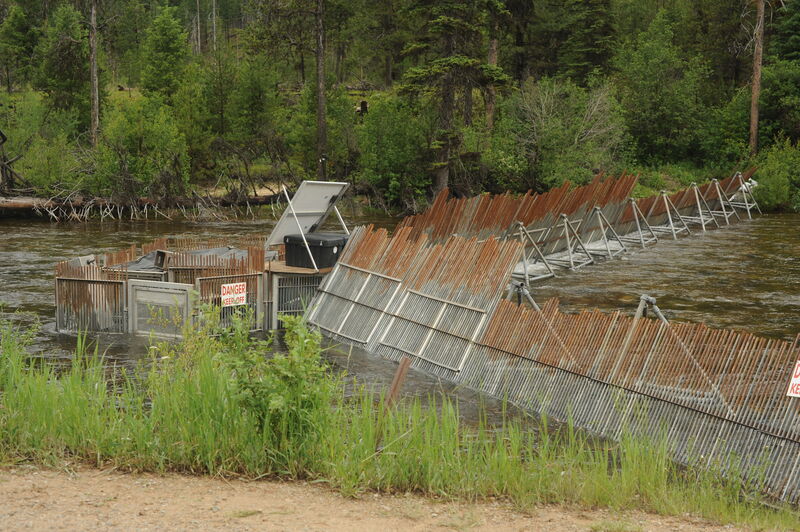
How's Your
River
×
Explore
Explore Map
Water Bodies
Gauges
Access Sites
Tidal Stations
Whitewater
Pricing
Login
Sign Up
Hazard Warning:
Hazard information may be user-submitted and unverified. Conditions change frequently. Always scout rapids and obstacles yourself.
Whitewater
Idaho
Johnson Creek - Yellow Pine airport to Johnson Creek gauge
Fish Weir
Portage
ID
Fish Weir
Johnson Creek - Yellow Pine airport to Johnson Creek gauge (ID)
Monitor this Rapid
Water Body
This Run
Map
Other Rapids
Gauge
Weather
Directions
Gauge Conditions
Johnson Creek at Yellow Pine ID
Downstream
Primary
Runnable: 300.0 – 1,500.0 CFS
Data from
American Whitewater
&
USGS
Photo
Photo courtesy of
American Whitewater
Location
Radar
Counties
Cell
Verizon
AT&T
T-Mobile
Dark
Satellite
Terrain
Other Rapids on This Run (2)
Rapid
N/A
Put In
0.0 mi
Rapid
N/A
Take Out
5.0 mi
Type
Portage
Difficulty
Class N/A
Mile Marker
0.2 mi
Directions
Navigate
View Full Run
Yellow Pine airport to Johnson Creek gauge
Johnson Creek
II(III)
5.0 mi
Portage recommended
— Scout before running and consider carrying around this feature.
Current Conditions
5-Day Forecast
Whitewater data from
American Whitewater
Fish Weir