Rapid
VA
Access - Rt. 670 Mt. Zion Rd.
Save this feature with the run it belongs to.
Gauge Conditions
Runnable: 350.0 – 5,000.0 CFS
Best boatable flows uncertain. Help out by adding a comment or report.
Data from American Whitewater & USGS
Photo
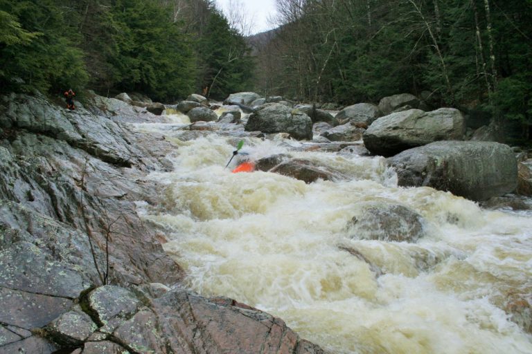
Photo courtesy of American Whitewater
Description
The Walker Creek rapid at Mt. Zion Road presents a challenging entry point with potential technical navigation through potential rocky sections near river right. Limited information suggests paddlers should carefully scout the access and riverbed conditions before attempting, as the lack of a defined difficulty rating indicates potential variability in water flow and obstacle configuration.
Location
Other Rapids on This Run (12)
Rapid
N/A
Put In - Rt. 608
 Rapid
N/A
Rapid
N/A
Access - Rt. 608 bridge
Rapid
N/A
Access - Rt. 738
 Rapid
N/A
Rapid
N/A
Access - Kimberling Creek confluence
Rapid
N/A
Access - Old Church Ln bridge
 Hazard
N/A
Hazard
N/A
Dam - Portage
Rapid
N/A
Access - Spring along Rt. 42
Portage
N/A
Portage - low water bridge
Rapid
N/A
Access - Rt. 100 at Little Walker Creek
Rapid
N/A
Access - Rt. 749 low water bridge
Rapid
N/A
Access - Farley Wayside park
Rapid
N/A
Take Out
View Full Run
Bland (Route 608) to New R. (Route 636)
Walker Creek
I-II
50.0 mi
Current Conditions
5-Day Forecast
Whitewater data from
American Whitewater
American Whitewater