Playspot
MI
Confluence Squirt Spot
Save this feature with the run it belongs to.
Gauge Conditions
Runnable: ? – ? CFS
Approximate - nearest available gauge. Use as general reference only.
Data from American Whitewater & USGS
Photo
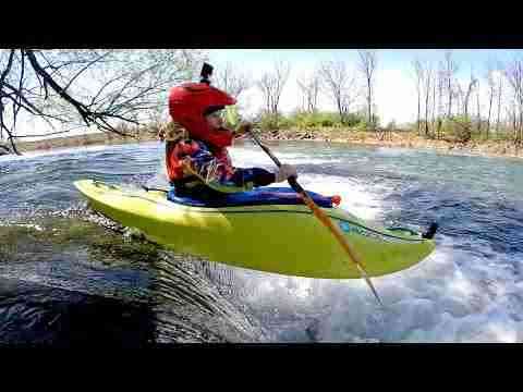
Photo courtesy of American Whitewater
Description
Just before the take-out, the East Branch encounters the Middle Branch Ontonagon. This confluence of currents creates squirt-boating opportunities.
Even in summer, this can provide some fine exercise for stalls and squirts. At such times, you can forego the full run, just park at the take-out (Military Hills Roadside Park). From there you can either put-in to paddle upstream ~200 yards --- OR --- carry northeast into the woods from the northeast end of the park to put-in and run about a quarter-mile rapids/shoals down to the confluence.
Even in summer, this can provide some fine exercise for stalls and squirts. At such times, you can forego the full run, just park at the take-out (Military Hills Roadside Park). From there you can either put-in to paddle upstream ~200 yards --- OR --- carry northeast into the woods from the northeast end of the park to put-in and run about a quarter-mile rapids/shoals down to the confluence.
Location
Other Rapids on This Run (3)

View Full Run
East Branch Rd to Hwy.45 (7.5 miles)
Ontonagon, E.Br.
II-III
7.6 mi
Current Conditions
5-Day Forecast
Whitewater data from
American Whitewater
American Whitewater