Rapid
CA
Gauge below Mendota
Save this feature with the run it belongs to.
Gauge Conditions
Runnable: 400.0 – 8,000.0 CFS
Near end
Data from American Whitewater & USGS
CDEC Flow Data California
Data from California Data Exchange Center (CDEC)
Description
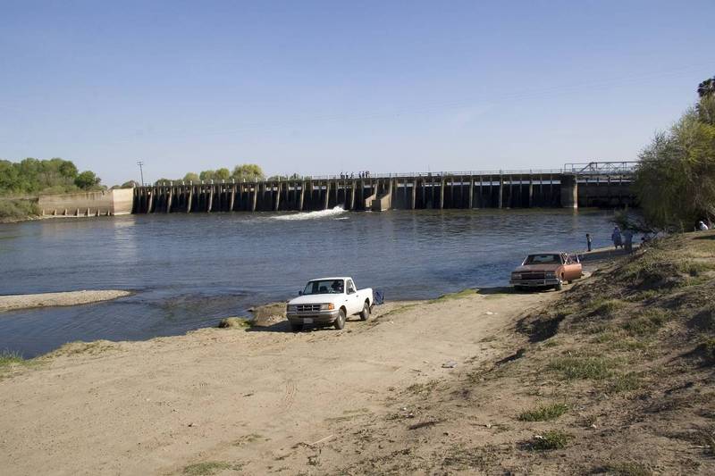
A Bureau of Reclamation gauging station is on river left. Water in this section is usually pumped from the delta, via the Delta-Mendota Canal. During the winter and spring flows can come from Friant, from Pine Flat via the Kings, pumped out of Tulare Lake or perhaps from west side creeks.
The gauge is housed in a vertical corrugated pipe with a solar panel on top. The cable crossing just downstream is used to measure the actual streamflow and calibrate the river level gauge.
Location
Other Rapids on This Run (13)
 Rapid
N/A
Rapid
N/A
Mendota Pool Dam
Rapid
N/A
Firebaugh Wasteway confluence
 Rapid
N/A
Rapid
N/A
Firebaugh Park
Portage
N/A
Sack Dam
Rapid
N/A
Gauge near Dos Palos
Rapid
N/A
Highway 152
Portage
N/A
Small Dam
Rapid
N/A
Chowchilla Bypass - Confluence
Rapid
N/A
Sandy Mush Road
Portage
N/A
Small Dam
Rapid
N/A
Highway 165 - Lander Ave
Rapid
N/A
Fremont Ford State Rec Area
Rapid
N/A
Merced River Confluence - Hills Ferry Road
View Full Run
Mendota Pool to Merced River Confluence
San Joaquin
I
86.3 mi
Current Conditions
5-Day Forecast
Whitewater data from
American Whitewater
American Whitewater