Hazard
WI
Undercut (Overhanging) Wall
Save this feature with the run it belongs to.
Gauge Conditions
Runnable: 160.0 – 500.0 CFS
Bang and scrape (too low to call whitewater).
Data from American Whitewater & USGS
Photo
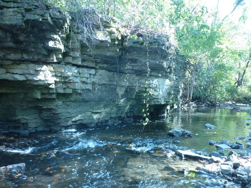
Photo courtesy of American Whitewater
Description
Coming out of the pool below Kil'n Ledge, the flow spills down brief rubble-filled gradient then heads toward a rock wall on river-left.
Large tree trunks had blocked this area for a few years. They have been cut so this should be passable next time there are boatable flows, but (once again) you really need to scout this area before putting on, to be sure there is no impassable wood in this stretch.
To avoid being stuffed into the undercut/overhanging wall, point bow to the right or even angled upstream and paddle to stay center-river!
Location
Interactive river map
Loads as you approach this section.
Other Rapids on This Run (13)
Rapid
N/A
Put-in Parking
 Playspot
II+
Playspot
II+
Bridge Wave
Rapid
II
First Pitch
 Playspot
II+
Playspot
II+
Upper Dells
 Hazard
II+
Hazard
II+
Heart of the Dells
Rapid
II
Lower Dells
 Waterfall
III
Waterfall
III
Kil'n Ledge
Rapid
N/A
The Straight-away
 Hazard
II
Hazard
II
Sweeping Left-hand Bend
 Hazard
I
Hazard
I
Confluence Shoals
Rapid
N/A
Take-out: Arthur Avenue
Rapid
N/A
Take-out Parking
Rapid
N/A
Pilgrim Road (USGS Gauge Location)
View Full Run
A) *2025.09.23 WOOD UPDATE* MenFalls: Main Street to Arthur Ave (0.4 mile)
Menomonee
II-III
0.4 mi
Hazard — Exercise extreme caution in this area.
Current Conditions
5-Day Forecast
Whitewater data from
American Whitewater
American Whitewater